Rawdon, West Yorkshire
Coordinates: 53°50′57″N 1°40′36″W / 53.8493°N 1.6766°W
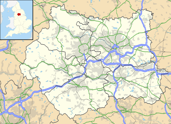
Rawdon is a village and civil parish in the metropolitan borough of the City of Leeds, West Yorkshire, England. The appropriate City of Leeds Ward population is Guiseley and Rawdon.
Early beginnings
With William the Conqueror was a commander of archers named Paulyn who rendered such faithful and courageous service to the Norman cause that he was rewarded with lands, a portion of which was the manor on Rawden Hill. Granting manors to military leaders was more than a matter of largesse on William’s part. It was the medieval method of controlling newly conquered countries. For Paulyn, as for scores of other new lords of new manors, it meant a continuing obligation to the new ruler, but it also meant a near guarantee of prosperity by means of a new family seat and the control over fiefdom.
At the time of invasion, Paulyn, in common with his peers, had no true surname, or family name. Surnames were not yet necessary to distinguish one man from another. In fact, it seems that the first real use of the surname came about because of the Norman invaders’ need to know how much land they controlled and what the value of the land was. To determine this, a census, called the Domesday Survey, was taken of the 5,500-or-so land-holding knights and each was identified with a surname.
If Paulyn was still alive when the Domesday Survey was made, we assume that he received his surname – taken from the place-name Rawden (as it was spelled at that time). He is generally referred to as Paulyn de Rawden, meaning simply Paulyn of Rawden Hill Manor.
“Rawden” means in Old English “rough valley.” The manor, or tract of land, on the hill near the “rough valley” awarded to Paulyn was on the River Aire in the former Urban District of Aireborough in Yorkshire, England’s largest county. Rawdon, as it is spelled nowadays, is a quiet residential village with a fine view of Aire valley.
Claims to fame
- Rawdon is famous as being the home town of cricketers Brian Close and Hedley Verity.
- Leeds United utility man Paul Madeley used to live in Rawdon.
- Benton Park School in Rawdon is used as a fictional location in the soap opera Emmerdale.
- Rawdon is situated next to Yeadon, where Leeds Bradford International Airport is located.
- William Thompson, a Quaker from Rawdon, is claimed to have been the first wool merchant in the country to import Australian wool (in 1808).[1] He lived in a house called "The Mount" situated between Town Street and Layton Avenue, which was formerly known as Back Lane. There is still an active Quaker meeting in Rawdon in the original building, built in 1697.
- Frazer Hines ex Doctor Who actor, and ex-Emmerdale star, used to live in the Little London area of Rawdon. Originally from nearby Horsforth
Areas of interest
Rawdon Billing is a hill and well known local landmark that can be seen from a considerable distance.
Rawdon has a conservation area called Little London which lies to the westernmost area of Rawdon. Little London conservation area is unique in that the historic area covered by the designation straddles the boundary of the district and one of its neighbours, Bradford. This area was, until the local government reorganisation in 1974, part of a district called Aireborough which was arbitrarily divided between Leeds and Bradford during reorganisation. The portion of the conservation area lying in Leeds was designated in 1975 and was extended in 1988. The portion of the conservation area lying in Bradford was designated in 1977. The Bradford designation centres on Lane Head House, built for the steward of Esholt Hall Estate c. 1710–1720, with its associated cottages, and outbuildings and other mainly late 18th century development completing the designation. Little London is at the westernmost tip of the contiguous urbanised settlement of Rawdon which coalesces with Guiseley, the centre of which is approximately 1 mile (1.5 km) to the northeast of the conservation area. Greengates, and the edge of the Bradford urban area, is 1.2 miles (2 km) to the south of Little London. The area to the west of the conservation area is rural Green Belt, with Esholt village lying 1.2 miles (2 km) to the west of Little London in the Green Belt.
There are many other places throughout the UK known as Little London.
Schools
There are two primary schools in Rawdon. Rawdon Littlemoor and Rawdon St Peters C of E Primary School.
Benton Park School on Harrogate road was built as a secondary school in 1960s.
Religion

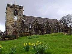
Rawdon is home to St Peter's Church which was built by Francis Layton as a chapel of ease for the parish of Guiseley in 1645. Due to the troubled times (English Civil War 1642–1651, then Cromwell's Commonwealth until the Restoration of the Monarchy in 1660) it took many years to erect the church. Francis Layton died in 1661, leaving his son Henry to continue with the building. It was finally consecrated in 1684. A tower was added in 1707 then the church was largely rebuilt in 1864 by architect Alexander Crawford at a cost of £1,200.[2]
Rawdon is also home to a Quaker meeting house built in 1697,[3] and the Trinity Church (Baptist, Methodist, United Reform). This is housed in the former Benton Congregational Church (1846), being renamed in 1972 by the three groups who now share it.[3]
Location grid
 |
Guiseley | Yeadon | Bramhope | |
| Esholt | |
Horsforth | ||
| ||||
| | ||||
| Apperley Bridge | Calverley | Rodley |
References
- ↑ Rigg, Martin (1990). Round and About Aireborough. Vol 3.
- ↑ "St Peters Church". Aireborough Historical Society. Retrieved 20 November 2014.
- 1 2 D. C. Willcock (2000) A History of Rawdon
External links
| Wikimedia Commons has media related to Rawdon, West Yorkshire. |
- The Leeds Quakers Website. The Religious Society of Friends (Quakers) in Leeds, Otley, Gildersome, Rawdon & Ilkley
- "The Ancient Parish of Guiseley". GENUKI. Retrieved 29 October 2007. Rawdon was in this parish
Further reading
- D. C. Willcock (2000) A History of Rawdon online version
- Rawdon Little London Conservation Area & Management Plan (2011)