Rauma (river)
| Rauma | |
|---|---|
 View of the river | |
| Country | Norway |
| Basin | |
| Main source |
Lesjaskogsvatnet 611 m (2,005 ft) above sea level |
| River mouth |
Åndalsnes/Veblungsnes 0 m (0 ft) above sea level |
| Basin size | 1,202 km2 (464 sq mi) |
| Physical characteristics | |
| Length | 68 km (42 mi) |
The Rauma is a river that runs through Romsdalen, a valley in Møre og Romsdal and Oppland counties in Norway. It runs for 68 kilometres (42 mi) from Lesjaskogsvatnet, a lake in the municipality of Lesja, to the town of Åndalsnes in the municipality of Rauma. The river was once famous for its salmon-fishing, but since an infection with Gyrodactylus salaris only 5 to 10% of the original stock survives. The salmon runs up to the Slettafoss, a 16-metre (52 ft) high combination of waterfalls and rapids more than 42 kilometres (26 mi) upriver from the estuary.
The Rauma River and its valley are regarded as one of the most beautiful in Norway. The river runs very clear with a green tint and the mountains tower some 1,500 to 1,800 metres (4,900 to 5,900 ft) above the river in the lower and middle parts of the valley. The Reinheimen National Park and the Trollveggen cliff are both located along the southwestern shores of the river through the municipality of Rauma. The Romsdalsalpene mountains surround the river and the valley, including the mountains Store Trolltind, Store Venjetinden, Trollryggen, and Romsdalshornet. The Rauma Line railroad follows the river through the valley on its way north to Åndalsnes. The railroad crosses the river on the Kylling Bridge at the village of Verma.
The Rauma was classified as a protected watercourse in 1992, and the only main tributary affected by hydroelectric power is the Verma River with the over 300-metre (980 ft) Verma Falls. The biggest tributaries are the Ulvåa and Istra. The Istra runs through the Ister Valley, well known for Trollstigen Road in its upper parts.[1]
The meaning of the name Rauma is unknown (it is probably very old).
Media gallery
 Stuguflåt Bridge
 Mouth of the river at Åndalsnes
 Close up picture of the river
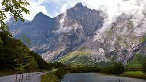 Mountains surrounding the river valley
References
- ↑ Store norske leksikon. "Rauma – elv" (in Norwegian). Retrieved 2010-10-27.
External links
 Media related to Rauma River at Wikimedia Commons
Coordinates: 62°33′27″N 7°40′41″E / 62.5575°N 7.67806°E