Ratchaburi Province
| Ratchaburi ราชบุรี | ||
|---|---|---|
| Province | ||
| ||
 Map of Thailand highlighting Ratchaburi Province | ||
| Country |
| |
| Capital | Ratchaburi town | |
| Government | ||
| • Governor | Suraphon Sawaengsak (since October 2014) | |
| Area | ||
| • Total | 5,196.5 km2 (2,006.4 sq mi) | |
| Area rank | Ranked 43rd | |
| Population (Ranked 28th) | ||
| • Total | 853,217 | |
| • Density | 160/km2 (430/sq mi) | |
| • Density rank | Ranked 22nd | |
| Time zone | ICT (UTC+7) | |
| ISO 3166 code | TH-70 | |

Ratchaburi or Rat Buri (Thai: ราชบุรี), is one of the western provinces (changwat) of Thailand. Neighbouring provinces are (from north clockwise) Kanchanaburi, Nakhon Pathom, Samut Sakhon, Samut Songkhram and Phetchaburi. In the west it borders Tanintharyi Division of Myanmar.
Ratchaburi is 80 kilometres west of Bangkok and borders Burma to the west with the Tanaosi Range as a natural borderline.[1] The Mae Klong River flows through the centre of Ratchaburi town.
Geography

Ratchaburi Province is medium-sized province with an area of about 5,196 km2. The eastern part of the province contains the flat river plains of the Mae Klong River, crisscrossed by many khlongs. The most famous tourist spot in this area are the floating markets of Damnoen Saduak. The west of the province is more mountainous, and includes the Tanawsri mountain range. As the mountains are made mostly of limestone, there are several caves containing stalactites. Some caves are inhabited by large colonies of bats, and it is an impressive sight when they swarm out in the evening to feed. Other caves like the Khao Bin are accessible for visitors. The main river of the western part is the Phachi River.
On the left bank of the Phachi River is the Chaloem Phra Kiat Thai Prachan National Park.
The area of Ratchaburi province is divided into three parts. First, the border in the west which is shared with Burma and is about 60 km long. The second contains the Tenasserim mountains and forests with an elevation of about 200–300 meters. The central area of the province is rich in wetlands due to river flow. Ratchaburi has important natural resources are forest which it have area about 38% of the province. Moreover, it has minerals such as tin, tantalum, feldspar, quartz, limestone, and marlstone.[2]
History

The history of the city of Ratchaburi dates back to the Dvaravati period, when it was an important city of the Mon Kingdom. Of the city of Khu Bua nearby only ruins remains. According to legend it dates back to the mythical Suvannabhumi Kingdom predating Dvaravati.
"Ratchaburi" means "the land of the king".[3] Ratchaburi dates back to ancient times and was important during the Dvaravati period. The city of Ratchburi is on the banks of the Mae Klong River and was a town of the Suvarnabhumi Kingdom. Burma lies to its west with the Tanaosi range (Tenasserim Hills) forming the border.
Demographics
1.1 percent of the population are members of the hill tribes, mostly Karen living near the Myanmar border. Some Mon, Lawa, Lao, Chinese and Khmer minorities live in the province.[4]
Symbols
The provincial seal shows the royal sword above the royal sandals on a phan (tray), as the name Ratchaburi means "city of the king". The name derives from the fact that King Rama I was born here. The provincial slogan is Beautiful women of Photharam, beautiful women of Baan Pong, the city of earthenware jars, shadow plays at Wat Khanon, magnificent caves, floating market at Damnoen, bats, delicious Yii Sok fish.[5]
The provincial flower is the Pink Shower Tree (Cassia bakeriana), and the provincial tree is Wrightia pubescens.
Administrative divisions

The province is subdivided into 10 districts (amphoe).[6] The districts are further subdivided into 104 subdistricts (tambon) and 935 villages (muban).
|
|
There are three towns (thesaban mueang), Ratchaburi, Ban Pong and Photharam, and 11 townships (thesaban tambon).
Tourism
Attractions
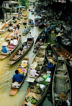
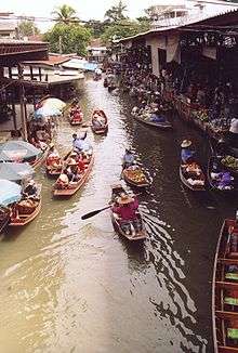
Damnoen Saduak Floating Market Damnoen Saduak Floating Market is in the Damnoen Saduak district.[7] It shows the people's lifestyle and the importance of the river as a mean of commerce. The vendors paddle their boats up and down the waterways selling and bartering their merchandise.[8] The markets start in very early morning until 11:00.
Wat Phra Si Ratana Mahathat An ancient temple, locally called Wat Na Phra That, is on the west bank of the Mae Klong River in town.[9] Its elegant prangs or pagoda remains in good condition and was probably copied from Cambodia's Angkor Wat. The prang made of bricks and a stone stands on a rectangular base with pathways around the cloisters. The outer stucco designs were made in the reign of King Borommakot of Ayutthaya. Buddha images of Dvaravati, Lop Buri and Ayutthaya periods are placed around the pagoda.
Murals of Wat Khongkharam At a Mon monastery over 200 years old and originally called "Wat Klang" or "Phia To". King Mongkut gave it a new name as "Wat Khongkharam". It is Photharam, some 22 kilometres from Ratchaburi.[9]
'Bo Khloung Hot Stream - Five kilometers beyond Suan Phung. The stream is full of mineral water. The water flows all year round from the Tanaosi Range. Its temperature ranges between 50-68 degrees Celsius. On the route to the hot stream, a three kilometre branch road leads to Namtok (waterfall) Kao Chon, which consists of nine cascades. The waterfall is plentiful during the late rainy season.[3]
Kaew Chan Waterfall or Nine-Level waterfall - is one kilometer from Bo Khlung hot stream. Kaew Chan's name was given by Princess Sirindhorn. As the name indicates, the water cascades from the ninth level and down the central valley of steep cliff, especially during the rainy season when there is always a lot of water at the top level. It is possible to walk up to the ninth level. It takes about two hours.

Pong Yub is at Ban Tha Kheay. The subsidence of the ground has created a steep cliff similar to the one in Pae Muang Phi in Phrae Province.
Khao Bin Cave About 22 kilometres from Ratchaburi city centre is the mountain range of "Khao Bin", or "Flying Mount" which is home to the cave of the same name. Inside the cave there are stalagmites and stalactites. It was one of these stalagmites in the shape of a majestic giant eagle with its wings outspread which gave the cave its name. Also inside the cave there is a small mineral spring which villagers believe is sacred.
Khao Wang A hill that is about 44 metres high and was originally called "Khao Sattanat". It is two kilometers west of the town. King Rama V had commanded a palace to be built on the hill and made a royal visit to receive the Portuguese minister in 1887. The palace area was donated by King Rama VII to be used as a monastery, which was later called "Wat Khao Wang".
Festivals
Ratchaburi Tourism Fair (งานเที่ยวราชบุรี) Held every year during February–March on the ground of the city hall. Activities include demonstrations of famous handicrafts, such as jar making and "Sin Tin Chok" cloth weaving, the selling of OTOP (One Tambon, One Product) and agricultural produce, and folk art and cultural performances by local tribal groups.
Sweet Grape and Damnoen Saduak Floating Market Week Fair (งานเทศกาลองุ่นหวานและตลาดน้ำดำเนินสะดวก) - is held around March–April of every year to introduce agricultural produce to the market, especially grapes which most people grow in Amphoe Damnoen Saduak. Damnoen Saduak Grape is famous for its sweetness and good taste. This fair features the beauty contest of Thida A-ngun Wan and the competition of quality agricultural products.
Khao Ho or Ang Mi Thong Festival (ประเพณีกินข้าวห่อ หรือ อั๊งหมี่ทอง) A Su Khwan ceremony or the blessing ceremony for happiness and longevity in life, held around the ninth lunar month. Karens believe that the ninth lunar month is a bad time when ghosts and evil hunt and eat "khwan", the spirit of people, so those people may get sick or die. Normally, this ceremony is often held on the full moon day of the ninth lunar month, but if some families are not convenient, they can change to any day in the ninth month. In the ceremony, people boil "khao ho" which is sticky rice molded and wrapped in a cone shape; then they will boil it like khanom chang. In the past, they ate khao ho by dipping it in honey but at present they often dip it in sliced coconut. On the day they boil khao ho, the Su Khwan Ceremony will be held. It starts with poking a wooden plate and blowing a khaen for entertainment. Then the elders in each family will tie red threads on children's wrists and give a blessing for good luck.
References
- ↑ "Ratchaburi". Tourist Authority of Thailand (TAT). Retrieved 28 May 2015.
- ↑ "Ratchaburi have important "natural resources"". Retrieved 4 Nov 2013.
- 1 2 Choomjit, Y. (1994). History of Ratchaburi. Bangkok: Odienstore.
- ↑ Ratchaburi
- ↑ "Welcome to Ratchaburi Province, Thailand". Welcome to Ratchaburi Province, Thailand. Retrieved 28 May 2015.
- ↑ Ratchaburi is divided into "10 districts", Retrieved 4 Nov 2013, from http://www.encyclopediathai.org/sunthai/center/ratburi/ratburi.htm
- ↑ Asksara, Y. (2000). The West of Tanaosi Range. Bangkok: Sangdadpuertammachad.
- ↑ "Ratchaburi,". (1989). Goods of Ratchaburi: P.T.C. Corporation.
- 1 2 "Ratchaburi,". (1998). Ratchaburi. Bangkok: Sarakadee.
External links
 Ratchaburi travel guide from Wikivoyage
- Ratchaburi Thai Only
- English Website of Province Archived May 6, 2008, at the Wayback Machine.
- Ratchaburi Samanachan Archived March 31, 2012, at the Wayback Machine.
| Wikimedia Commons has media related to Ratchaburi Province. |
 |
Kanchanaburi Province | Nakhon Pathom Province | | |
| |
|
Samut Sakhon Province | ||
| ||||
| | ||||
| Phetchaburi Province | Samut Songkhram Province |
Coordinates: 13°31′44″N 99°48′52″E / 13.52889°N 99.81444°E