Rappahannock River
| Rappahannock River | |
|---|---|
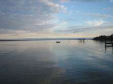 The Rappahannock at sunset | |
| Country | United States (Lancaster County, Middlesex County, Essex County, Richmond County, Westmoreland County, King George County, Caroline County, Stafford County, Spotsylvania County, City of Fredericksburg, Culpeper County, Fauquier County, Rappahannock County) |
| Basin | |
| Main source |
Chester Gap 1,720 feet (520 m) |
| River mouth | Chesapeake Bay |
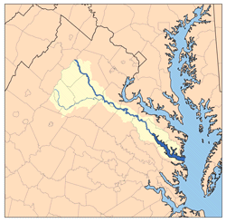
| Basin size | 2,848 sq mi (7,380 km2) |
| Physical characteristics | |
| Length | 195 miles (314 km) |
| Discharge |
|
The Rappahannock River is a river in eastern Virginia, in the United States, approximately 195 miles (314 km) in length.[2] It traverses the entire northern part of the state, from the Blue Ridge Mountains in the west, across the Piedmont, to the Chesapeake Bay, south of the Potomac River.
An important river in American history, the Rappahannock was the site of early settlements in the Virginia Colony, and, later, was at the center of a major theatre of battle in the American Civil War. Due to its significance as an obstacle to north-south movements, it in effect functioned as the war's eastern-theatre boundary, between the "North" (the Union) and the "South" (the Confederate States of America).
The river drains an area of 2,848 square miles (7,380 km2), approximately 6% of Virginia. Much of the watershed is rural and forested, but it has experienced increased development in recent decades because of the southward expansion of the Washington, D.C. suburbs.
Description of the watercourse
The Rappahannock River rises at Chester Gap, a wind gap in the Blue Ridge Mountains a few miles southeast of Front Royal, Virginia, near the single point where Warren, Fauquier, and Rappahannock counties come together. It flows southeastward, past Remington, Kelly's Ford, and Richardsville, before it is joined by the Rapidan River, its largest tributary, from the right. Then the Rappahannock passes through the city of Fredericksburg. Southeast of Fredericksburg, it begins to slow and widen into a brackish tidal estuary approximately 50 miles (80 km) long. It passes two small, but historic, river towns, Port Royal and Port Conway, which sit opposite each other, the former on the south bank, the latter on the north. Then it flows past Tappahannock on its southern bank, a point where the river is well over a mile wide. The last settlements of any size before reaching the Chesapeake Bay are Irvington, Urbanna, Stingray Point, and White Stone Beach.
The broad river enters the Chesapeake Bay approximately 20 miles (32 km) south of the mouth of the Potomac River and approximately 60 miles (97 km) east of the state capital, Richmond. At the point where the river enters the bay, between Windmill Point, on the north, and Stingray Point, on the south, it is more than 3.5 miles (5.6 km) wide. This area, the estuary south of the Northern Neck peninsula, is a productive oyster and crab fishery.
Above Fredericksburg, the Rappahannock provides fine opportunities for recreational canoeing and kayaking. Most of the rapids are Class I and Class II in difficulty, but, near Remington, there are some rapids that are considered to be Class III.
The rivers watershed is protected in various places by parcels of the Rappahannock River Valley National Wildlife Refuge.
The oysters
The oysters that thrive in the estuary of the Rappahannock River are the least salty oysters on the East Coast. They are renowned for their sweet and smooth flavor. The animal tastes almost buttery. The low salinity allows a Blue Ridge minerality[3] to come through, and also makes it easy to combine with wine.
The nutritious oysters were eaten on a large scale in 19th century Washington. They were served fresh, grilled, stewed or as part of a pie.
History
The name of the river comes from an Algonquian word, lappihanne (also recorded as toppehannock), meaning "river of quick, rising water" or "where the tide ebbs and flows," the name used by the local native population, the Rappahannock tribe.
Although there had been a few small hamlets along the lower Rappahannock during early colonial times, the settlement of the Rappahannock River valley began in earnest during the first years of the eighteenth century, at the urging of Governor Alexander Spotswood. The James River had been surveyed up to its fall line, the point where, geologically, continental bedrock of the Piedmont meets the sedimentary rocks and alluvial soils of the coastal plain. Spotswood encouraged settlement in a river valley other than that of the James. In 1714, he began soliciting immigrants from the Rhineland-Palatinate and Switzerland to homestead on lands he controlled near the confluence of the Rappahannock and the Rapidan. Known as the Germanna settlement(s), these villages were founded in order to exploit the iron ore deposits of the region.
The Battle of Rappahannock River was fought on the river during the War of 1812. Seventeen British boats filled with hundreds of marines and sailors captured four American privateers.
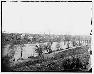
During the American Civil War, the river, with few convenient fords and fewer bridges, provided a barrier and defensive line behind which movements of troops could be accomplished with little fear of attack from the river-side flank. It was an especially difficult barrier for Union troops to overcome in their attempts to thrust into southern Virginia. Control of the river changed hands many times during the course of the war. Significant battles fought along the river include the Battle of Fredericksburg and the Battle of Rappahannock Station. The defensive line at the river was finally circumvented by Ulysses S. Grant in the Wilderness (or Overland) Campaign of 1864, ending in the ultimate Union victory.
In some 18th- and 19th-century documents, including some Civil War records, the Rappahannock River was referred to as "Hedgeman's River";[4] a 1736-1737 survey labeled the Rappahannock above the mouth of the Rapidan as "Cannon", and further upstream it was identified as "Hedgeman's River," named after Nathaniel Hedgeman, an early settler of the region.[5]
See also
- Ferry Farm
- Knights of the Golden Horseshoe Expedition
- List of Virginia rivers
- Stingray Point Light
- Windmill Point Light
- List of rivers of Virginia
References
- ↑ USGS data, accessed 2010-06-14
- ↑ U.S. Geological Survey. National Hydrography Dataset high-resolution flowline data. The National Map, accessed April 1, 2011
- ↑ See: 2012
- ↑ Rappahannock River
- ↑ A History of Orange County, Virginia by W. W. Scott
External links
- Friends of the Rappahannock
- "Rappahannock River watershed". Archived from the original on September 8, 2006.
- Rappahannock River Valley National Wildlife Refuge
- Virginia Dept. of Conservation and Recreation: Rappahannock Tributary Strategy
- Early Settlement on the Rappahannock
- Wade Fishing the Rappahannock River of Virginia
- Belle Isle State Park
- U.S. Geological Survey Geographic Names Information System: Rappahannock River
Coordinates: 37°35′15″N 76°17′21″W / 37.58750°N 76.28917°W