Randolph, Missouri
| Randolph, Missouri | |
|---|---|
| City | |
 Location of Randolph, Missouri | |
| Coordinates: 39°9′31″N 94°29′40″W / 39.15861°N 94.49444°WCoordinates: 39°9′31″N 94°29′40″W / 39.15861°N 94.49444°W | |
| Country | United States |
| State | Missouri |
| County | Clay |
| Area[1] | |
| • Total | 0.35 sq mi (0.91 km2) |
| • Land | 0.33 sq mi (0.85 km2) |
| • Water | 0.02 sq mi (0.05 km2) |
| Elevation | 768 ft (234 m) |
| Population (2010)[2] | |
| • Total | 52 |
| • Estimate (2012[3]) | 35 |
| • Density | 157.6/sq mi (60.8/km2) |
| Time zone | Central (CST) (UTC-6) |
| • Summer (DST) | CDT (UTC-5) |
| ZIP codes | 64117, 64161 |
| Area code(s) | 816 |
| FIPS code | 29-60590[4] |
| GNIS feature ID | 0755566[5] |
Randolph is a city in Clay County, Missouri.[6] The population was 52 at the 2010 census.
History
An early variant name was "East Kansas City".[7] The name of the post office changed from East Kansas City to Randolph in 1920, and the post office closed in 1928.[8]
Geography
Randolph is located at 39°9′31″N 94°29′40″W / 39.15861°N 94.49444°W (39.158653, -94.494410).[9]
According to the United States Census Bureau, the city has a total area of 0.35 square miles (0.91 km2), of which, 0.33 square miles (0.85 km2) of it is land and 0.02 square miles (0.05 km2) is water.[1] Randolph is on the banks of the Missouri River. It is surrounded by Kansas City on all land borders, and the opposite side of the Missouri is also Kansas City.[10]
Demographics
| Historical population | |||
|---|---|---|---|
| Census | Pop. | %± | |
| 1930 | 138 | — | |
| 1940 | 188 | 36.2% | |
| 1950 | 206 | 9.6% | |
| 1960 | 219 | 6.3% | |
| 1970 | 106 | −51.6% | |
| 1980 | 91 | −14.2% | |
| 1990 | 60 | −34.1% | |
| 2000 | 47 | −21.7% | |
| 2010 | 52 | 10.6% | |
| Est. 2015 | 54 | [11] | 3.8% |
2010 census
As of the census[2] of 2010, there were 52 people, 24 households, and 14 families residing in the city. The population density was 157.6 inhabitants per square mile (60.8/km2). There were 26 housing units at an average density of 78.8 per square mile (30.4/km2). The racial makeup of the city was 98.1% White and 1.9% Asian. Hispanic or Latino of any race were 1.9% of the population.
There were 24 households of which 20.8% had children under the age of 18 living with them, 41.7% were married couples living together, 12.5% had a female householder with no husband present, 4.2% had a male householder with no wife present, and 41.7% were non-families. 33.3% of all households were made up of individuals and 8.4% had someone living alone who was 65 years of age or older. The average household size was 2.17 and the average family size was 2.71.
The median age in the city was 47.5 years. 17.3% of residents were under the age of 18; 7.7% were between the ages of 18 and 24; 19.2% were from 25 to 44; 34.5% were from 45 to 64; and 21.2% were 65 years of age or older. The gender makeup of the village was 59.6% male and 40.4% female.
2000 census
As of the census[4] of 2000, there were 47 people, 20 households, and 14 families residing in the city. The population density was 137.7 people per square mile (53.4/km²). There were 22 housing units at an average density of 64.5 per square mile (25.0/km²). The racial makeup of the city was 95.74% White, and 4.26% from two or more races.
There were 20 households out of which 15.0% had children under the age of 18 living with them, 55.0% were married couples living together, 15.0% had a female householder with no husband present, and 30.0% were non-families. 20.0% of all households were made up of individuals and 5.0% had someone living alone who was 65 years of age or older. The average household size was 2.35 and the average family size was 2.64.
In the city the population was spread out with 14.9% under the age of 18, 6.4% from 18 to 24, 38.3% from 25 to 44, 21.3% from 45 to 64, and 19.1% who were 65 years of age or older. The median age was 39 years. For every 100 females there were 123.8 males. For every 100 females age 18 and over, there were 110.5 males.
The median income for a household in the city was $53,750, and the median income for a family was $53,750. Males had a median income of $31,667 versus $35,000 for females. The per capita income for the city was $23,067. None of the population and none of the families were below the poverty line.
Audit
In 2010, Randolph was cited by Missouri State Auditor Susan Montee for violating the state's speed trap law, by funding over 73% of the city budget from traffic violations.[13]
References
- 1 2 "US Gazetteer files 2010". United States Census Bureau. Retrieved 2012-07-08.
- 1 2 "American FactFinder". United States Census Bureau. Retrieved 2012-07-08.
- ↑ "Population Estimates". United States Census Bureau. Retrieved 2013-05-30.
- 1 2 "American FactFinder". United States Census Bureau. Retrieved 2008-01-31.
- ↑ "US Board on Geographic Names". United States Geological Survey. 2007-10-25. Retrieved 2008-01-31.
- ↑ http://www.claycoelections.com/elected-officials/clay-county-officials.html
- ↑ "Clay County Place Names, 1928–1945 (archived)". The State Historical Society of Missouri. Retrieved 21 September 2016.
- ↑ "Post Offices". Jim Forte Postal History. Retrieved 21 September 2016.
- ↑ "US Gazetteer files: 2010, 2000, and 1990". United States Census Bureau. 2011-02-12. Retrieved 2011-04-23.
- ↑ ANdriot, John L. Township Atlas of the United States" (McLean, Virginia: Andriot Associates, 1979) p. 366
- ↑ "Annual Estimates of the Resident Population for Incorporated Places: April 1, 2010 to July 1, 2015". Retrieved July 2, 2016.
- ↑ "Census of Population and Housing". Census.gov. Retrieved June 4, 2015.
- ↑ Frankel, Todd. "Missouri's first official speed-trap town fingered in audit" St. Louis Post-Dispatch, 15 September 2010.
Kansas City metropolitan area's cities and counties | ||
|---|---|---|
| Central city |  | |
| Largest cities (over 100,000 in 2000) | ||
| Medium-sized cities (10,000 to 100,000 in 2000) | ||
| Smaller Cities (between 5,000 and 9,900 in 2010) | ||
| Counties | ||
Municipalities and communities of Clay County, Missouri, United States | ||
|---|---|---|
| Cities | 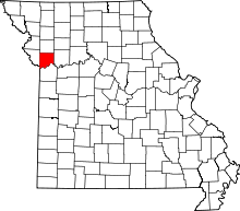 | |
| Villages | ||
| Townships |
| |
| Unincorporated communities | ||
| Footnotes | ‡This populated place also has portions in an adjacent county or counties | |