Rancho San Antonio County Park
| Rancho San Antonio County Park and Open Space Preserve | |
|---|---|
|
A meadow grasslands in Rancho San Antonio County Park. | |
  | |
| Location | Santa Clara County, California, United States |
| Nearest city | Cupertino, California |
| Coordinates | 37°19′52″N 122°5′34″W / 37.33111°N 122.09278°WCoordinates: 37°19′52″N 122°5′34″W / 37.33111°N 122.09278°W |
| Area | 4,078 acres (16.50 km2) |
| Governing body | Midpeninsula Regional Open Space District |
| Website | Open Space Preserve and County Park |

Rancho San Antonio County Park is a public recreational area in the Santa Cruz Mountains, Santa Clara County, in northern California. Saint Joseph's College was once on this land.
The adjacent Rancho San Antonio Open Space Preserve is part of the Midpeninsula Regional Open Space District, which manages both the Open Space Preserve and the County Park.[1] Both areas protect much of the upper watershed of Permanente Creek, except the portion in Lehigh Quarry. Together, they are approximately 4,078 acres (16.50 km2) in area and contain 23 miles (37 km) of hiking trails.
History
The Ohlone Indians lived in the area for over 3,000 years prior to the arrival of the Spanish. A large village, known as Partacsi, was located in the general area. In March, 1776 Juan Bautista de Anza led the first overland expedition to San Francisco Bay from Monterey through this area. In de Anza's diary on March 25, 1776, he states that he "arrived at the arroyo of San Joseph Cupertino (now Stevens Creek), which is useful only for travelers. Here we halted for the night, having come eight leagues in seven and a half hours. From this place we have seen at our right the estuary which runs from the port of San Francisco." [2] A prominent hill between Permanente and Stevens Creeks is referred to as "De Anza's Knoll" and marks the location where the explorer first spotted the Bay.
Governor Alvarado granted Rancho San Antonio to Juan Prado Mesa in 1839. Mesa had been a soldier at the San Francisco Presidio since 1828. In 1853, William A. Dana, a former seafarer and merchant, purchased the Rancho. In 1923, the Catholic Church purchased what had become the Snyder Ranch and in 1926 and constructed Saint Joseph's Seminary (which was badly damaged in the 1989 Loma Prieta earthquake and demolished) and the Maryknoll Seminary. The Maryknoll Seminary, with its oriental motif, stands east of the park across Cristo Rey Drive. The Santa Clara County Parks Department purchased 130 acres in 1977 and another 35 acres in 1981 from St. Joseph's Seminary. The Park's improvements were constructed in the early 1980s with additional improvements completed in 1993.[3]
Habitat and conservation
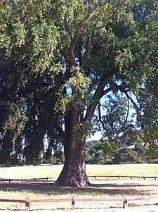
The State's tallest and third largest California bay laurel tree (Umbellularia californica), estimated to be over 200 years old, grows in Rancho San Antonio County Park. When it was protected by fencing and removal of a nearby handball court in 2004, it was 126 feet tall with a trunk circumference of 360 inches, and a canopy spread of 118 feet. In 1869, the wood of a California Bay Laurel was used for the “Last Tie” connecting North America’s first transcontinental railroad. The tree's leaves are highly aromatic and its small yellow flowers bloom between December and April, important to bees at a time when few other plants are in bloom.[4]
Several ecosystems exist in the park. In canyons, bay trees and big-leaf maples form shady groves. Along creeks, several species of willow grow, and cottonwoods are found in a couple areas. On cooler, north-facing slopes, oaks and bays form a forest. On hotter, south-facing slopes, chaparral scrub of chamise, manzanita, and birch-leaf mountain mahogany predominates. Douglas-fir, common west of the crest of the Santa Cruz Mountains, can be seen as lone trees above the Rouge Valley trail, and along the Black Mountain trail; they are the only conifer in the park. Ridges support grassland and scattered oaks.
The park and preserve are important as they protect the entire watershed of West Fork Permanente Creek which begins on Ewing Hill and flows east. It is joined by Ohlone Creek just above Deer Hollow Farm, and then to the mainstem of Permanente Creek, eventually flowing north under Interstate 280 through the cities of Los Altos and Mountain View where it enters the San Francisco bay.The Permanente riparian corridor is crucial for wildlife survival, providing food and water as well as the ability to migrate through suburban areas relatively undisturbed.
Deer Hollow Farm is home to native species such as deer, mountain lion and bobcat. The big cats are tracked and thus far have posed no threat to humans. Visitors are warned of the presence of the animals with signs at the entrance to the preserve and various trail map stations. The Rancho San Antonio land preserve is one of the few remaining tracts of land in Silicon Valley in which native animals such as these roam free.[5]
Recreation
Deer Hollow Farm is an educational center where the public can observe, study and participate in a working farm. The 150-year-old Farm covers ten acres and stands as a reminder of Santa Clara County's agricultural history. In the tradition of a working homestead, Deer Hollow Farm continues to produce food on-site. The farm is home to a variety of animals including chickens, rabbits, goats, sheep, pigs and a cow. Farm fresh eggs and seasonal orchard produce are for sale when available.[4] It is a one-mile easy walk west from the Rancho parking lots along the West Fork Permanente Creek. The restored Grant Ranch Cabin has been furnished to represent living conditions in the late 1800s. The Deer Hollow Farm section of the Rancho San Antonio land preserve is managed by the City of Mountain View recreation division. The city manages all Farm programs and ensures that no further development takes place on the land. The city of Mountain View is instrumental in the preservation of the area and protects the environment against human intervention.[6]
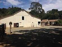
The historic open air hay barn rests at the north end of the farm. Visitors can rest and have picnics at the many wooden picnic tables available for public use. Visitors may also take self-guided tours of the surrounding area, which includes the livestock pens. Although the public cannot interact directly with the farm animals, they are able to observe them from a short distance. In addition, an environmentally sustainable vegetable garden neighbors the open air hay barn. Deer Hollow Farm volunteers maintain the garden and plant seasonal vegetables. This garden is utilized as part of the farm’s education program.
As part of Deer Hollow Farm’s commitment to environmental education, including sustainable farming and food growth, the farm offers a variety of educational programs for a range of ages. These programs include a Nature center, which is housed in an old apple shed (one of the original 1850’s buildings), School Year Classes for kindergarten through fifth graders, which offer farm and garden education, exploration of the wilderness preserve, Ohlone Indian education, and Summer Wilderness Camps for children in grades one through nine which encourage exploration of the preserve and hands-on learning.[7]
Rancho San Antonio also contains various hikes such as the Chamise Trail which leads to the Duveneck Windmill Pasture Area and connects to the Black Mountain Trail which climbs to the summit of Black Mountain. Other trails provide shorter easier loops.[8]
Deer Hollow Farm is supported through the organization Friends of Deer Hollow Farm. This organization’s mission is to support the farm as a working homestead as well as support environmental and historical education that benefits community members. FODHF was formed in 1994. As the last working homestead in Silicon Valley, it is important that it be preserved and maintained. Friends of Deer Hollow Farm supports Deer Hollow Farm by providing educational classes that deal with the area’s history. These classes cover the Ohlone Indian history of the area. Before the Spanish arrived in the West, the Rancho San Antonio land preserve was occupied by the Ohlone Tribe. FODHF carries on their traditions and their history with the land through their education programs. There are over 100,000 visitors to Deer Hollow Farm each year, and 5,000 local children participate in the variety of camps and activities offered year round. The extent to which visitors utilize the open space preserve shows how important it is to the Silicon Valley community.[9]
Bicycles are restricted to designated trails only, and are not permitted west of Deer Hollow Farm. Similarly, equestrians are limited to the equestrian staging area and Coyote Trail, within the County Park.
See also
References
- ↑ Rancho San Antonio County Park and Open Space Preserve (Map and Information Brochure). Santa Clara County Parks and Midpeninsula Regional Open Space District. May 2014.
- ↑ de Anza, Juan Bautista (1776). Diary of Juan Bautista de Anza October 23, 1775 - June 1, 1776. http://anza.uoregon.edu/anza76.html Accessed September 8, 2009 University of Oregon Web de Anza pages
- ↑ "Rancho San Antonio Open Space Preserve: Cultural History" (PDF). Midpeninsula Open Space Preserve. Retrieved 2012-03-25.
- ↑ Kristi Webb (2004-04-27). "Laurel and Hearty: The State's Third Largest California Bay Laurel Tree Gets Space to Grow" (PDF). Retrieved 2012-03-25.
- ↑ "Silicon Valley". Retrieved November 29, 2012.
- ↑ "Deer Hollow Farm". Retrieved 29 November 2012.
- ↑ "Educational Programs". Retrieved 29 November 2012.
- ↑ "Trail Map of Rancho San Antonio County Park and Open Space Preserve" (PDF). Midpeninsula Regional Open Space District. Retrieved 2012-03-25.
- ↑ "Friends of Deer Hollow Farm". Retrieved 29 November 2012.
External links
- Rancho San Antonio County Park at Santa Clara County Parks web site
- Hiking trails map - Santa Clara County park map
- Rancho San Antonio Open Space Preserve - openspaces.org
- Friends of Deer Hollow Farm