Ramagundam
| Ramagundam రామగుండం رامگنڈم | |
|---|---|
| City | |
|
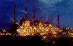
Ramagundam Super Thermal Power Station | |
 Ramagundam  Ramagundam Location in Telangana State, India | |
| Coordinates: 18°45′50″N 79°28′30″E / 18.76389°N 79.47500°ECoordinates: 18°45′50″N 79°28′30″E / 18.76389°N 79.47500°E | |
| Country | India |
| State | Telangana |
| District | Peddapalli |
| Named for | Lord Rama |
| Government | |
| • Type | Mayor-council |
| • Body | Ramagundam Municipal Corporation |
| • Mayor | Konkati Laxminarayana |
| • M.L.A | Somarapu Satyanarayana |
| Area[1] | |
| • Total | 93.87 km2 (36.24 sq mi) |
| Elevation | 179 m (587 ft) |
| Population (2015)[1] | |
| • Total | 287,644 |
| • Rank |
175th (India) 5th (Telangana) |
| • Density | 3,100/km2 (7,900/sq mi) |
| Languages | |
| • Official | Telugu |
| Time zone | IST (UTC+5:30) |
| PIN | 505 xxx |
| Telephone code | 08728 |
| Vehicle registration | TS-22 |
| Website | Ramagundam Municipal Corporation |
Ramagundam is a city is in the Peddapalli district of the Indian state of Telangana. It is the biggest and most populous city in the Peddapalli district. It is located on the banks of the Godavari river. The City of Ramagundam gets its name from a combination of two words: (Rama + Gundam). A famous temple of the Hindu God Lord Rama is situated in the old part of the city and ‘Gundam’ means Water Springs. Ramagundam is known as city of Energy. As of 2015 census, the city had a population of 287,644, making it the 5th most populous in the state.[1]
Geography
Ramagundam is located at 18°48′00″N 79°27′00″E / 18.8000°N 79.4500°E.[2] It has an average elevation of 179 meters (590 feet). It is about 250 Kilometers (155 mi) north east of state capital, Hyderabad, 60 km from Karimnagar And 5 km from Godavarikhani
Climate
| Climate data for Ramagundam, India (1981–2010) | |||||||||||||
|---|---|---|---|---|---|---|---|---|---|---|---|---|---|
| Month | Jan | Feb | Mar | Apr | May | Jun | Jul | Aug | Sep | Oct | Nov | Dec | Year |
| Average high °C (°F) | 30.5 (86.9) |
33.4 (92.1) |
37.2 (99) |
40.1 (104.2) |
41.9 (107.4) |
37.3 (99.1) |
32.5 (90.5) |
31.4 (88.5) |
33.1 (91.6) |
33.1 (91.6) |
31.6 (88.9) |
30.2 (86.4) |
34.4 (93.9) |
| Average low °C (°F) | 15.7 (60.3) |
18.3 (64.9) |
21.9 (71.4) |
25.6 (78.1) |
28.2 (82.8) |
27.2 (81) |
25.1 (77.2) |
24.6 (76.3) |
24.5 (76.1) |
22.1 (71.8) |
17.7 (63.9) |
14.6 (58.3) |
22.1 (71.8) |
| Average precipitation mm (inches) | 13.5 (0.531) |
8.8 (0.346) |
8.3 (0.327) |
13.7 (0.539) |
28.3 (1.114) |
163.4 (6.433) |
308.0 (12.126) |
297.2 (11.701) |
175.6 (6.913) |
85.8 (3.378) |
21.3 (0.839) |
5.5 (0.217) |
1,129.2 (44.457) |
| Source: Indian Meteorological Department[3] | |||||||||||||
Demographics
As of 2011 India census,[4][5][6] Ramagundam had a population of 229,644. Males constitute 51% of the population and females 49%. Ramagundam has an average literacy rate of 69%: male literacy is 75.3%, and female literacy is 62.4%. In Ramagundam, 8% of the population is under 6 years of age. Ramagundam is only municipal corporation in Peddapalli district.
Politics
Somarapu Satyanarayana, won as MLA in 2014 elections from Ramagundam constituency and he is appointed as Telangana's first TSRTC Public Transport Chairman.[7]
Economy
Ramagundam city is situated in the Godavari valley coalfields and has one of the India's largest Thermal Power stations in south region under NTPC. Mostly industries are connected with Godavarikhani- NTPC Ramagundam. Some of them are Fertilizer Corporation of India, Kesoram Cement, Basanth Nagar, National Fertilizers Limited, Engineers India Limited, TSGENCO thermal power station, Kesoram (Birla) cement factories, NTPC (RSTPS – Ramagundam Super Thermal Power Station) sourcing 2600 MW of power 24/7 and the TSSEB (Telangana State Electricity Board) unit at Ramagundam. Another 1600MW (2x800MW) is proposed as RDM-II as per expansion plan by NTPC Limited. NTPC’s first SPV or Solar photovoltaic unit of capacity 25MW (Phase-I 1x10MW, Phase-II 1x15MW) has been proposed at Ramagundam. This would help in earning carbon credits against use of solar power as renewable energy source. Also, Sripada Yellampalli project ,an irrigation project,is located at near of Ramagundam
Transport
Road
One Highway is Connected with Hyderabad-Karimnagar-Ramagundam Hwy TSRTC operates buses and connects Ramagundam (Godavarikhani) to major parts of the state.[8] Godavarikhani depot runs city buses in Ramagundam Corporation limits.[9] This city is directly connected by road to capital city Hyderabad by SH 1. TSRTC provides large number of busses to Hyderabad, Karimnagar, Hanamkonda etc.
Rail
Ramagundam railway station falls under the jurisdiction of Secunderabad railway division of South Central Railway zone.[10] It is one of the major railway station in the state as well as in the north-south railway line.
Air
Ramagundam Airport is the airport situated in Basanthnagar of the Godavarikhani City. Its one of the oldest airport at the time of Nizam's. As its industrially developed area it has good scope to develop airport in this region by state government.[11] The state government has plans to reopen the airport.
Police Commissionerate
Ramagundam Police Commissionerate is a city police force with primary responsibilities in law enforcement and investigation within Peddapalli, Ramagundam and Mancherial areas.[12][13]
References
| Wikimedia Commons has media related to Ramagundam. |
- 1 2 3 "Basic Information of Municipality". Official website of Ramagundam Municipal Corporation. Retrieved 17 May 2016.
- ↑ "redirect to /world/IN/02/Ramgundam.html".
- ↑ "CLIMATOLOGICAL TABLE PERIOD: 1981–2010". Indian Meteorological Department. Retrieved 2016-06-16.
- ↑ "Ramagundam (M)(802907)". censusindia.gov.in 2011 Indian Census. 2011. Retrieved 2014-08-23.
- ↑ "Ramagundam (M + OG) (Part)(802907)". censusindia.gov.in 2011 Indian Census. 2011. Retrieved 2014-08-23.
- ↑ "Census of India 2001: Data from the 2001 Census, including cities, villages and towns (Provisional)". Census Commission of India. Archived from the original on 2004-06-16. Retrieved 2008-11-01.
- ↑ http://www.metroindia.com/cities/article/29/04/2016/somarapu-to-take-charge-as-rtc-chief-today/30560
- ↑ "City bus services flagged off in Karimnagar". The Hindu. 12 January 2016. Retrieved 30 June 2016.
- ↑ "Transport Minister P. Mahender Reddy and Finance Minister Etala Rajender flagging off JNNURM city bus service, in Godavarikhani coal belt area in Karimnagar – worldtvnews". 26 June 2016.
- ↑ "Jurisdiction Map of Secunderabad Division". South Central Railway. Retrieved 30 June 2016.
- ↑ Ramagundam Airport
- ↑ http://www.thehindu.com/news/cities/Hyderabad/Ramagundam-made-police-commissionerate/article9205689.ece
- ↑ http://www.thehindu.com/news/national/telangana/minister-reviews-arrangements-for-police-commissionerates/article9207123.ece