Raleigh Hills, Oregon
| Raleigh Hills, Oregon | |
|---|---|
| Census-designated place (CDP) | |
|
| |
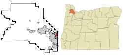 Location of Raleigh Hills, Oregon | |
| Coordinates: 45°29′5″N 122°45′20″W / 45.48472°N 122.75556°WCoordinates: 45°29′5″N 122°45′20″W / 45.48472°N 122.75556°W | |
| Country | United States |
| State | Oregon |
| County | Washington |
| Area | |
| • Total | 1.5 sq mi (4.0 km2) |
| • Land | 1.5 sq mi (4.0 km2) |
| • Water | 0.0 sq mi (0.0 km2) |
| Elevation | 282 ft (86 m) |
| Population (2010) | |
| • Total | 5,896 |
| • Density | 3,829.5/sq mi (1,478.6/km2) |
| Time zone | Pacific (PST) (UTC-8) |
| • Summer (DST) | PDT (UTC-7) |
| FIPS code | 41-60900[1] |
| GNIS feature ID | 1158435[2] |
Raleigh Hills is a census-designated place and neighborhood within the metropolitan area of Portland, Oregon, in the United States. It is located in the southwest hills in Washington County, with Beaverton to the west, West Slope to the north, and Progress and Garden Home to the south. As of the 2000 census, the census-designated place had a total population of 5,865.
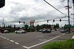
Raleigh Hills is located at the intersection of Oregon Routes 10 and 210. Fire protection and EMS services are provided through Tualatin Valley Fire and Rescue.
History
Raleigh Hills was named after Raleigh Robinson, a resident of the neighborhood.[3] A post office named Raleigh was established in the area April 1892, and was closed twelve years later.[3] Southern Pacific's Red Electric line had a stop in Raleigh from 1914 until the line ceased operation in 1929. A Raleigh Hills branch of the Portland post office was opened in 1968.[3]
Geography
Raleigh Hills is located at 45°29'5" North, 122°45'20" West (45.484790, -122.755575).[4]
According to the United States Census Bureau, the neighborhood has a total area of four km² (1.5 sq mi), none of which is covered with water.
Demographics
As of the census[1] of 2000, there are 5865 people in the neighborhood, organized into 2586 households and 1561 families. The population density is 3,829.5 people per square mile (1,480.1/km²). There are 2,786 housing units at an average density of 1,819.1/sq mi (703.1/km²). The racial makeup of the CDP is 90.08% White, 3.10% Asian, 0.99% African American, 0.31% Native American, 0.19% Pacific Islander, 3.34% from other races, and 1.99% from two or more races. 5.75% of the population are Hispanic or Latino of any race.
There are 2,586 households out of which 25.6% have children under the age of 18 living with them, 50.8% are married couples living together, 6.3% have a female householder with no husband present, and 39.6% are non-families. 33.4% of all households are made up of individuals and 12.5% have someone living alone who is 65 years of age or older. The average household size is 2.26 and the average family size is 2.91.

In the neighborhood the population is spread out with 21.5% under the age of 18, 6.5% from 18 to 24, 25.6% from 25 to 44, 28.2% from 45 to 64, and 18.2% who are 65 years of age or older. The median age is 43 years. For every 100 females there are 95.3 males. For every 100 females age 18 and over, there are 90.4 males.
The median income for a household in the neighborhood is $60,714, and the median income for a family is $83,300. Males have a median income of $60,186 versus $34,769 for females. The per capita income for the CDP is $37,839. 7.4% of the population and 5.0% of families are below the poverty line. Out of the total population, 11.7% of those under the age of 18 and 2.0% of those 65 and older are living below the poverty line.
References
- 1 2 "American FactFinder". United States Census Bureau. Retrieved 2008-01-31.
- ↑ "US Board on Geographic Names". United States Geological Survey. 2007-10-25. Retrieved 2008-01-31.
- 1 2 3 McArthur, Lewis A.; McArthur, Lewis L. (2003) [1928]. Oregon Geographic Names (7th ed.). Portland, Oregon: Oregon Historical Society Press. p. 797-798. ISBN 978-0875952772.
- ↑ "US Gazetteer files: 2010, 2000, and 1990". United States Census Bureau. 2011-02-12. Retrieved 2011-04-23.
External links
- Beaverton Valley Times, the neighborhood's local newspaper
- Citizen Participation Organization 3, the area neighborhood association
- Raleigh Water District
Municipalities and communities of Washington County, Oregon, United States | ||
|---|---|---|
| Cities | 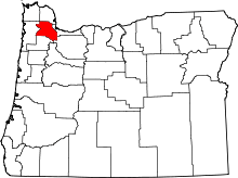 | |
| CDPs | ||
| Unincorporated communities |
| |
| Ghost towns | ||
| Footnotes | ‡This populated place also has portions in an adjacent county or counties | |