Raja Ampat Islands
|
Map of the islands | |
 Raja Ampat Islands | |
| Geography | |
|---|---|
| Archipelago | Raja Ampat Islands |
| Total islands | 612 |
| Major islands |
Misool Salawati Batanta Waigeo |
| Area | 40,000 km2 (15,000 sq mi)(land area = 8,034 km2) |
| Administration | |
| Demographics | |
| Population | 49,048 (2014) |
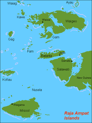
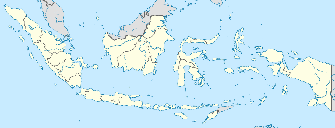
Located off the northwest tip of Bird's Head Peninsula on the island of New Guinea, in Indonesia's West Papua province, Raja Ampat, or the Four Kings, is an archipelago comprising over 1,500 small islands, cays, and shoals surrounding the four main islands of Misool, Salawati, Batanta, and Waigeo, and the smaller island of Kofiau. The Raja Ampat archipelago is the part of Coral Triangle which contains the richest marine biodiversity on earth.
Raja Ampat Regency is a new regency which separated from Sorong Regency in 2004.[1] The population of the Regency was recently (January 2014) put at 49, 048. It encompasses more than 40,000 km² of land and sea, which also contains Cenderawasih Bay, the largest marine national park in Indonesia. It is a part of the newly named West Papua province of Indonesia which was formerly Irian Jaya. Some of the islands are the most northern pieces of land in the Australian continent.
Raja Ampat is considered the global epicenter of tropical marine bio-diversity and is referred to as The Crown Jewel of the Bird's Head Seascape, which also includes Cenderawasih Bay and Triton Bay.
History
The name of Raja Ampat comes from local mythology that tells about a woman who finds seven eggs. Four of the seven eggs hatch and become kings that occupy four of Raja Ampat biggest islands whilst the other three become a ghost, a woman, and a stone.
History shows that Raja Ampat was once a part of Sultanate of Tidore, an influential kingdom from Maluku. Yet, after the Dutch invaded Maluku, it was shortly claimed by the Netherlands.
The first recorded sighting and landing by Europeans of the Ampat Islands was in the person of the Portuguese navigator Jorge de Menezes and his crew in 1526, on route from Biak, the Bird's Head Peninsula, and Waigeo, to Halmahera (Ternate).
The English explorer William Dampier gave his name to Dampier Strait, which separates Batanta island from Waigeo island. To the east, there is a strait that separates Batanta from Salawati. In 1759 Captain William Wilson sailing in the East Indiaman Pitt navigated these waters and named one strait Pitt strait, after his vessel; this was probably the channel between Batanta and Salawati.
Population
The main occupation for people around this area is fishing since the area is dominated by the sea. They live in a small colony of tribes that spreads around the area. Although traditional culture still strongly exists, they are very welcoming to visitors. Raja Ampat people are more like Ambonese than Papuan people and now some of them are Muslim and some of them are Christian.[2]
Geography

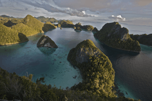
The oceanic natural resources around Raja Ampat give it significant potential as a tourist area. Many sources place Raja Ampat as one of their top ten most popular places for diving whilst it retains the number one ranking in terms of underwater biodiversity.
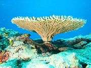
According to Conservation International, marine surveys suggest that the marine life diversity in the Raja Ampat area is the highest recorded on Earth.[3] Diversity is considerably greater than any other area sampled in the Coral Triangle composed of Indonesia, Malaysia, Philippines, Papua New Guinea, Solomon Islands, and East Timor. The Coral Triangle is the heart of the world's coral reef biodiversity, making Raja Ampat quite possibly the richest coral reef ecosystems in the world.
The area's massive coral colonies along with relatively high sea surface temperatures, also suggest that its reefs may be relatively resistant to threats like coral bleaching and coral disease, which now jeopardize the survival of other coral ecosystems around the world. The Raja Ampat islands are remote and relatively undisturbed by humans.
The high marine diversity in Raja Ampat is strongly influenced by its position between the Indian and Pacific Oceans, as coral and fish larvae are more easily shared between the two oceans. Raja Ampat's coral diversity, resilience, and role as a source for larval dispersal make it a global priority for marine protection.
1,508 fish species, 537 coral species (a remarkable 96% of all scleractinia recorded from Indonesia are likely to occur in these islands and 75% of all species that exist in the world[4]), and 699 mollusk species, the variety of marine life is staggering.[5] Some areas boast enormous schools of fish and regular sightings of sharks, such as wobbegongs.
Raja Ampat Islands have at least three ponds containt unpoisoned jellyfish, all in Misool area.[6]
Although accessing the islands is not that difficult, it takes some time. It takes six hours flight from Jakarta, the capital city of Indonesia to Sorong. Then, taking a boat to reach the islands is necessary.
Documentary film
The documentary film Edies Paradies 3 (by Otto C. Honegger) has been broadcast by the biggest Switzerland television broadcaster, Schweizer Fernsehen. The film tells about Raja Ampat's natural underwater beauty which is likened to Switzerland's only inhabited area of the region of around 50,000 residents and is considered like the "Amazon" because of the underwater world located in the heart of the world's Coral Triangle.[7]
Weather
Tropical Weather. From October to April is the best time to visit Raja Ampat. The temperatures range from 20 to 33 ºC.[8]
See also
References
- ↑ Raja Ampat, Hasanuddin University sign MoU | The Jakarta Post
- ↑ Mitra Tarigan (June 30, 2014). "The Other Side of Raja Ampat".
- ↑ Ultra Marine: In far eastern Indonesia, the Raja Ampat islands embrace a phenomenal coral wilderness, by David Doubilet, National Geographic, September 2007
- ↑ Tom Allard (2 July 2011). "Sea of trouble". The Age. Retrieved 10 July 2014.
- ↑ (PDF) https://web.archive.org/web/20101025223155/http://www.conservation.org/Documents/RAP_Reports/RAP22_Raja_Ampat_Indonesia_Apr-2002.pdf. Archived from the original (PDF) on October 25, 2010. Retrieved October 3, 2010. Missing or empty
|title=(help) Conservation International, 2002, A Marine Rapid Assessment of the Raja Ampat Islands, Papua Province, Indonesia - ↑ "Tujuh Danau Ubur-Ubur Unik di Indonesia". Retrieved November 5, 2014.
- ↑ "Pesona Raja Ampat Difilmkan di Swiss". February 1, 2012. Archived from the original on February 2, 2012.
- ↑ "All about Raja Ampat". Retrieved November 30, 2016.
External links
| Wikimedia Commons has media related to Raja Ampat. |
-
 Raja Ampat travel guide from Wikivoyage
 - Bird's Head Seascape
Regencies and cities of West Papua | ||
|---|---|---|
Capital: Manokwari | ||
| Regencies | ||
| Cities | ||