Rainbow Bridge (Niagara Falls)
| Rainbow Bridge | |
|---|---|
|
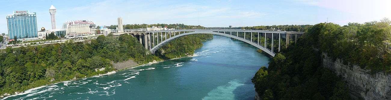
Rainbow Bridge as seen from Canada, 2013 | |
| Carries |
4 lanes of |
| Crosses | Niagara River |
| Locale | Niagara Falls, Ontario and Niagara Falls, New York |
| Official name | Niagara Falls International Rainbow Bridge |
| Maintained by | Niagara Falls Bridge Commission |
| Characteristics | |
| Design | Arch bridge |
| Total length | 1,450 ft (440 m)[1] |
| Height | 202 ft (62 m)[1] |
| Longest span | 960 ft (290 m)[1] |
| History | |
| Construction cost | $4 million[1] |
| Opened | November 1, 1941 |
| Statistics | |
| Toll |
US-to-Canada only: 3.50 USD/CAD per auto ($3.25 with ExpressPass/Prepaid NEXUS) 50 cents USD/CAD per pedestrian/bicycle[2] |

The Niagara Falls International Rainbow Bridge, commonly known as the Rainbow Bridge, is an arch bridge across the Niagara River gorge, and is a world-famous tourist site. It connects the cities of Niagara Falls, New York, United States (to the east), and Niagara Falls, Ontario, Canada (west).
Construction
The Rainbow Bridge was built near the site of the earlier Honeymoon Bridge, which collapsed on January 27, 1938, due to an ice jam in the river. A joint Canadian and American commission had been considering a new bridge to replace it, and the collapse added urgency to the project.

A design by architect Richard (Su Min) Lee was chosen (and used again for the Lewiston-Queenston Bridge, approximately 10 kilometres (6 mi) downriver). King George VI and Queen Elizabeth, during their visit to Niagara Falls as part of the 1939 royal tour of Canada, dedicated the site of the Rainbow Bridge; a monument was erected to commemorate the occasion. Construction began in May 1940. The bridge officially opened on November 1, 1941.
The origin of the bridge's name is unknown, with one possible source being T.B. McQuesten, then chairman of the Niagara Parks Commission. An engraving on the Canadian side of the bridge includes a biblical quote from the Book of Genesis which references a "bow in the clouds." Regardless of its origin, the NRBC used the name as early as March 1939.[3]
Description and specifications
The New York State Department of Transportation designates the bridge as NY 955A, an unsigned reference route, while the Ontario Ministry of Transportation designates it as part of Highway 420 (and the original routing of the Queen Elizabeth Way), even though it is separated from the rest of the route by a regional road. On the American side, a number of state and national routes end at a set of intersections in front of the bridge. New York routes 104 and 384, as well as the northern section of the Robert Moses State Parkway, all terminate at the final intersection before the bridge, and none of the designations passes onto the bridge. U.S. Route 62 terminates two blocks north at route 104, which then continues to the bridge. The complex on the Canadian side of the Rainbow Bridge features the Rainbow Tower, which houses a large carillon that sounds several times daily.
The bridge permits no commercial trucks; the nearest border crossing for these is the Lewiston-Queenston Bridge.[4]
The toll to cross the bridge for each pedestrian and bicycle is 50¢ USD or CAD, and $3.50 USD or CAD for automobiles. Car tolls are collected when leaving the United States. Pedestrian toll is collected by an automatic turnstile when leaving Canada.[2]
Gallery
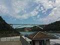 The bridge as viewed from the Canadian side.
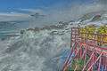 The bridge as seen from Cave of the Winds
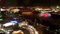 Bridge and Falls at night
Cityscape
See also
References
- 1 2 3 4 "Celebrating Eight Decades of Award-winning Bridges" (PDF). Modern Steel Construction. American Institute of Steel Construction. November 2011. p. 23 (page 2 in PDF). Archived (PDF) from the original on March 4, 2016. Retrieved November 8, 2016.
- 1 2 Niagara Falls Bridge Commission: Toll Cost & Vehicle Definitions
- ↑ Stamp, Robert M. (1992). Bridging the Border: Structures of Canadian–American Relations. Toronto: Dundurn Press. p. 128. ISBN 1-55002-074-9.
- ↑ Niagara Falls Bridge Commission: Which Bridge to Take?
External links
| Wikimedia Commons has media related to Rainbow Bridge Niagara Falls. |
- Niagara Falls Bridge Commission
- Google Maps view of Rainbow Bridge
- Live Traffic Camera of Rainbow Bridge
- Images from the Historic Niagara Digital Collections
- Rainbow Bridge at Structurae
| Bridges of the Niagara River | ||||
|---|---|---|---|---|
| ||||
Coordinates: 43°5′24.84″N 79°4′3.88″W / 43.0902333°N 79.0677444°W