Raiatea
| Native name: <span class="nickname" ">Ra'iātea | |
|---|---|
|
| |
 | |
| Geography | |
| Location | Pacific Ocean |
| Coordinates | 16°49′S 151°27′W / 16.817°S 151.450°WCoordinates: 16°49′S 151°27′W / 16.817°S 151.450°W |
| Archipelago | Society Islands |
| Major islands | Raiatea |
| Area | 167.7 km2 (64.7 sq mi) |
| Highest elevation | 1,017 m (3,337 ft) |
| Highest point | Mount Tefatua |
| Administration | |
| Overseas collectivity | French Polynesia |
| Largest settlement | 'Uturoa (pop. 3,778) |
| Demographics | |
| Population | 12,545[1] |
| Pop. density | 72 /km2 (186 /sq mi) |

Ra'iātea, is the second largest of the Society Islands, after Tahiti, in French Polynesia. The island is widely regarded as the 'centre' of the eastern islands in ancient Polynesia and it is likely that the organised migrations to Hawai'i, Aotearoa and other parts of East Polynesia started at Ra'iātea. A traditional name for the island is believed to be Havai'i.
Situated on the south east coast is the historical Taputapuātea which was established by 1000AD.
The main township on Ra'iātea is 'Uturoa, the administrative centre for the Leeward Islands (French Îles Sous-le-vent). There are also colleges which serve as the main educational location for secondary schools for students from the regional islands of Pora Pora, Taha'a, Huahine and Maupiti.
Etymology

The proper spelling of the name in the Tahitian language is Ra'iātea, meaning bright sky; Ulieta is an obsolete transcription commonly used in the 19th century. The extinct Ulieta bird originated from this island, along with other unknown species, there is only one drawing of it in the world which is in the Natural History Museum London.
Geography and population
The islands of Ra'iātea and Taha'a are enclosed by a single coral reef, and may once have been a single island. Ra'iātea is both the largest and most populated island in the Leeward Islands, with a land area of 167.7 km2 (64.7 sq mi) and a total population of 12,024 inhabitants at the August 2007 census. The population density is 72 inhabitants per km². The largest commune of Ra'iātea is 'Uturoa on the north side of Ra'iātea and has a population of nearly 10,000.
History
The first European to record sighting Ra'iātea was Pedro Fernandes de Queirós in 1606; it was charted as Fugitiva.[2] The Polynesian navigator, Tupaia, who sailed with explorer James Cook, was born in Ra'iātea around 1725. Omai (c.1751-1780), another young man from Ra'iātea, travelled with European explorers to London in 1774 and also served as an interpreter to Captain Cook on his second and third journey.
King Tamatoa VI was the last monarch, reigning from 1884-1888.
Transportation
Ra'iātea has a small road that runs around the entire island. Ra'iātea Airport is an airport in 'Uturoa.
Administration
The island is divided into three administration communes (municipalities):
These three communes are inside the administrative subdivision of the Leeward Islands.
Economy
The island economy is mainly agricultural with exports of vanilla, pineapple and coconut. The plant Nono (or noni) (Morinda citrifolia) is also grown. Fa'aroa Valley is a large and important agricultural region with the rural economy and the cultivation of vanilla supported by a local research facility. Pearl farming is also an important industry while farming cattle, sheep and pigs has decreased. There is less tourism compared to the other islands in the archipelago. The local tourist infrastructure comprises boarding houses, two marinas, a four star hotel, The Hawaiki Nui and a port for visiting cruise ships. There is also a fledgling local industry in the maintenance of yachts and shipbuilding. The main source of employment is the island's public service and the consumer market.
Gallery
.jpg) View of Ra'iātea island from a plane.
View of Ra'iātea island from a plane. Uturoa, seen from Tapioi
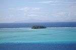 An island south of Ra'iātea with Huahine island in the background
 Looking down at the town of 'Uturoa and ocean.
 Ship at Ra'iātea.
 Another view of Taputapuātea marae.
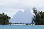 View of Pora Pora from Ra'iātea.
.JPG) Vanilla pods drying in the sun.
Vanilla pods drying in the sun. Portrait of Omai, oil on canvas, by Sir Joshua Reynolds, 1776
 Flag of the Kingdom of Raiatea from 1847 to 1880
See also
References
- ↑ Institut Statistique de Polynésie Française (ISPF). "Recensement de la population 2007" (PDF) (in French). Archived from the original (PDF) on 2007-12-03. Retrieved 2007-12-02.
- ↑ Burney, James A chronological history of the discoveries in the South Sea or Pacific Ocean London, 1803, vII, p.326.
Further reading
- "48 hours live to tell. Black wave". CBS News. 29 May 2010. Retrieved 2013-07-27.
We had just left an island called Ra'iātea, which was about 300 miles west of Tahiti.