Radnice
| Radnice | |||
| Town | |||
 The central square | |||
|
|||
| Country | Czech Republic | ||
|---|---|---|---|
| Region | Plzeň | ||
| District | Rokycany | ||
| Commune | Rokycany | ||
| Municipality | Radnice | ||
| Parts | Radnice, Svatá Barbora | ||
| Center | Náměstí Kašpara Šternberka | ||
| - elevation | 382 m (1,253 ft) | ||
| - coordinates | 49°51′27″N 13°36′26″E / 49.85750°N 13.60722°ECoordinates: 49°51′27″N 13°36′26″E / 49.85750°N 13.60722°E | ||
| Area | 10.64 km2 (4.11 sq mi) | ||
| Population | 1,767 (2016-01-01) | ||
| Density | 166/km2 (430/sq mi) | ||
| First mentioned | 1336 | ||
| Mayor | Josef Melich | ||
| Timezone | CET (UTC+1) | ||
| - summer (DST) | CEST (UTC+2) | ||
| Postal code | 338 28 | ||
  Location in the Czech Republic | |||
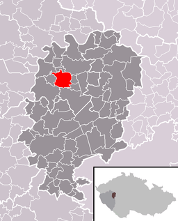 Location in Rokycany District | |||
| Wikimedia Commons: Radnice | |||
| Statistics: statnisprava.cz | |||
| Website: www.radnice.radnicko.cz | |||

| Radnice | |
| Municipality with Commissioned Local Authority | |
| Country | Czech Republic |
|---|---|
| Region | Plzeň |
| Little District | Rokycany |
| Municipalities | Bezděkov, Břasy, Bujesily, Hlohovice, Chlum, Chomle, Kamenec, Kladruby, Lhotka u Radnic, Liblín, Němčovice, Přívětice, Radnice, Sebečice, Skomelno, Újezd u Svatého Kříže, Vejvanov |
| Area | 147.15 km2 (56.81 sq mi) |
| Population | 6,005 (2005-12-31) |
| Density | 41/km2 (106/sq mi) |
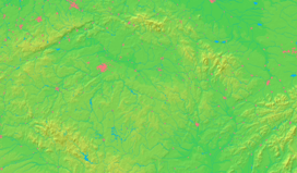
Radnice (Czech pronunciation: [ˈradɲɪtsɛ]) is a town in the Plzeň Region of the Czech Republic. It lies some 20 km (12 mi) to the northeast from the region capital of Plzeň.
Radnice is also the seat of the Municipality with Commissioned Local Authority within the Plzeň Municipality with Extended Competence.
In 19th century coal mining developed in vicinity of Radnice igniting industrial development, especially in the territory of Břasy. Radnice coal basin was depleted in 20th century and the region has partially reverted to the rural economy.
Famous People from Radnice
- Kaspar Maria von Sternberg, (1761-1838), Bohemian scientist, founder of the National Museum in Prague
- Antonín Jaroslav Puchmajer (1769-1820), Czech poet and linguist, served as a Catholic priest in Radnice
- Rabbi Isaac Mayer Wise (1819-1900), founder of American Hebrew Union College, served as a rabbi in Radnice
- Joseph Lewi (1820 - 1897), Jewish physician
- Božena Kamenická, (1898-1996), alternative medicine practitioner, also known as "Bába Radnická", since 1938 lived in Radnice [1]
- Václav Kotva, (1922-2004), Czech actor, born in Radnice
- Chotek family who originated from Chockov, nearby this city
- Radnitz, Radnitzer Jewish pedigree
- Josef Leopold Hůrka, (1925-2005), Czech freedom fighter, born in Radnice.
See also
References
Resources
- Czech Statistical Office (2005), Vybrané údaje podle správních obvodů obcí s rozšířenou působností a správních obvodů obcí s pověřeným obecním úřadem k 31. 12. 2005, retrieved 2005-03-08
![]() Media related to Radnice at Wikimedia Commons
Media related to Radnice at Wikimedia Commons
This article is issued from Wikipedia - version of the 11/21/2016. The text is available under the Creative Commons Attribution/Share Alike but additional terms may apply for the media files.