Rabbit Ears Range
| Rabbit Ears Range | |
|---|---|
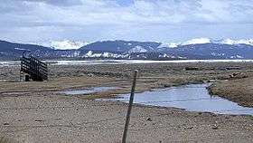 Cattle ramp outside Rand, Colorado looking south from Jackson County Road 27, with Rabbit Ears Range in the background. (April 4, 2005) | |
| Highest point | |
| Peak | Parkview Mountain |
| Elevation | 12,301 ft (3,749 m) [1] |
| Coordinates | 40°19′49″N 106°08′11″W / 40.33028°N 106.13639°W |
| Geography | |
| Country | United States |
| State | Colorado |
| County | Jackson and Grand |
| Range coordinates | 40°22′N 106°19′W / 40.36°N 106.31°WCoordinates: 40°22′N 106°19′W / 40.36°N 106.31°W |
| Parent range | Rocky Mountains |
The Rabbit Ears Range (elevation approximately 11,000 ft) is a mountain range of the Rocky Mountains in north central Colorado in the United States. The range stretches east-west along the continental divide forming the border between Grand and Jackson Counties, separating Middle Park (south) from North Park (north). The range connects the Front Range on the east with the Park Range and the Gore Range on the west. It is traversable at Willow Creek Pass. Muddy Pass separates the Rabbit Ears range to the east from the Park Range to the north.
Highest Peaks of the Rabbit Ears Range
- Parkview Mountain 12,301
- Sheep Mountain 11,819
- Elk Mountain 11,419
See also
References
External links
| Wikimedia Commons has media related to Rabbit Ears Range. |

This article is issued from Wikipedia - version of the 9/10/2016. The text is available under the Creative Commons Attribution/Share Alike but additional terms may apply for the media files.