Rabastens
Not to be confused with Rabastens-de-Bigorre.
| Rabastens | ||
|---|---|---|
|
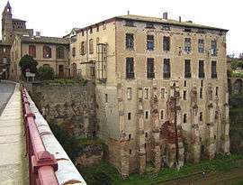
House on the River Tarn, in Rabastens | ||
| ||
 Rabastens | ||
|
Location within Occitanie region  Rabastens | ||
| Coordinates: 43°49′23″N 1°43′33″E / 43.8231°N 1.7258°ECoordinates: 43°49′23″N 1°43′33″E / 43.8231°N 1.7258°E | ||
| Country | France | |
| Region | Occitanie | |
| Department | Tarn | |
| Arrondissement | Albi | |
| Canton | Rabastens | |
| Intercommunality | Pays Rabastinois | |
| Government | ||
| • Mayor (2008–2014) | Alain Brest | |
| Area1 | 66.29 km2 (25.59 sq mi) | |
| Population (2006)2 | 4,875 | |
| • Density | 74/km2 (190/sq mi) | |
| Time zone | CET (UTC+1) | |
| • Summer (DST) | CEST (UTC+2) | |
| INSEE/Postal code | 81220 / 81800 | |
| Elevation |
95–252 m (312–827 ft) (avg. 117 m or 384 ft) | |
|
1 French Land Register data, which excludes lakes, ponds, glaciers > 1 km² (0.386 sq mi or 247 acres) and river estuaries. 2 Population without double counting: residents of multiple communes (e.g., students and military personnel) only counted once. | ||
.svg.png)
Rabastens is a commune in the Tarn department in southern France. The historian Gustave de Clausade (1815–1888) was born in Rabastens of which he became mayor in 1848.
Transport
See also
References
| Wikimedia Commons has media related to Rabastens. |
This article is issued from Wikipedia - version of the 9/13/2016. The text is available under the Creative Commons Attribution/Share Alike but additional terms may apply for the media files.