Raalte
| Raalte | |||
|---|---|---|---|
| Municipality | |||
| |||
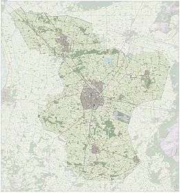
.svg.png) Location in Overijssel | |||
| Coordinates: 52°23′N 6°16′E / 52.383°N 6.267°ECoordinates: 52°23′N 6°16′E / 52.383°N 6.267°E | |||
| Country | Netherlands | ||
| Province | Overijssel | ||
| Government[1] | |||
| • Body | Municipal council | ||
| • Mayor | Martijn Dadema (GreenLeft) | ||
| Area[2] | |||
| • Total | 172.29 km2 (66.52 sq mi) | ||
| • Land | 171.08 km2 (66.05 sq mi) | ||
| • Water | 1.21 km2 (0.47 sq mi) | ||
| Elevation[3] | 5 m (16 ft) | ||
| Population (May 2014)[4] | |||
| • Total | 36,570 | ||
| • Density | 214/km2 (550/sq mi) | ||
| Demonym(s) | Raaltenaar, Raalter | ||
| Time zone | CET (UTC+1) | ||
| • Summer (DST) | CEST (UTC+2) | ||
| Postcode | 8055, 8100–8119, 8140–8144 | ||
| Area code | 0572 | ||
| Website |
www | ||

Raalte (![]() pronunciation ) is a municipality and a town in the heart of the region of Salland in the Dutch province of Overijssel.
pronunciation ) is a municipality and a town in the heart of the region of Salland in the Dutch province of Overijssel.
Population centres
The municipality consists of the following towns and villages. Raalte is the main place of the municipality, with over 20,000 mostly Roman Catholic inhabitants. It is a regional market, education and shopping centre.
| Town | Number of inhabitants |
|---|---|
| Raalte | 20,015 |
| Heino | 6,459 |
| Heeten | 4,231 |
| Luttenberg | 1,107 |
| Broekland | 617 |
| Nieuw-Heeten | 631 |
| Mariënheem | 633 |
| Laag Zuthem | 281 |
| Lierderholthuis | 176 |
| Source: CBS | |
Transport
Railway stations: Heino, Raalte
Raalte and Heino have railway stations along the minor railroad Zwolle - Enschede. Frequency: mostly twice per hour.
An important road for motorists is the N348 Deventer - Wesepe ( mun. Olst-Wijhe - Raalte - Lemelerveld - Ommen ( in northeasterly direction from Deventer). In Raalte it crosses a road (N35) from Zwolle going south-east over Heino, Raalte, Mariënheem and Nijverdal to Wierden, where it continues as a highway (A35) to Almelo and Enschede.
Economy
Raalte has a lot of small industrial enterprises, many of them processing agricultural products. For the local economy, trade, agriculture (especially breeding cattle) and tourism are more important.
Sights and Events
- Once a year there is a harvest festival called Stöppelhaene. Its name in regional dialect means: a rooster made out of straw. It is held in Raalte in the last week of August. The event was established in 1950.
- Luttenberg is famous for its motorcycle races every summer.
- Luttenberg is also famous for its Lourdes Cave, an artificial cave with a statue of the Virgin Mary of Lourdes, situated at the centre of the village opposing the parish church.
- South-west of Heino, just across the railroad and the border to the municipality Olst-Wijhe, stands the castle Nijenhuis. It hosts an important art museum ( Constant Permeke, Van Gogh et al.). Around the castle is a beautiful sculpture garden (Ossip Zadkine et al.).
- Near Luttenberg there is a small hill (Luttenberg) covered with heath and forest, where nice walks can be made.
- The Roman Catholic basilica "Kruisverheffing" (Exaltation of the Holy Cross) in Raalte. This Neo-Gothic church, designed by Alfred Tepe, was built in 1892. During "Stöppelhaene" there is an exposition of mosaics made out of seeds, representing religious themes. The festival starts and ends with special Holy Masses in this church.
- The small "Plaskerk", the oldest building in the centre of Raalte, is a Protestant church. A typical example of Dutch religious tolerance was the fact, that the Protestants were allowed to hold their Sunday services in the big Roman Catholic church, as the Plaskerk was restored in 2006.
Gallery
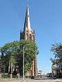 Raalte, church: Heilige Kruisverheffingskerk
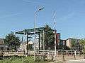 Raalte, drawing bridge
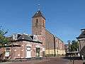 Heino, reformed church:de Zaalkerk
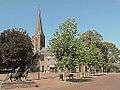 Heeten, church: kerk de Onze Lieve Vrouwe Onbevlekt Ontvangen
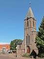 Nieuw Heeten, church: parochiekerk Sint Joseph
References
- ↑ "Samenstelling B en W" [Members of the board of mayor and aldermen] (in Dutch). Gemeente Raalte. Retrieved 31 March 2014.
- ↑ "Kerncijfers wijken en buurten" [Key figures for neighbourhoods]. CBS Statline (in Dutch). CBS. 2 July 2013. Retrieved 12 March 2014.
- ↑ "Postcodetool for 8101AC". Actueel Hoogtebestand Nederland (in Dutch). Het Waterschapshuis. Retrieved 31 March 2014.
- ↑ "Bevolkingsontwikkeling; regio per maand" [Population growth; regions per month]. CBS Statline (in Dutch). CBS. 26 June 2014. Retrieved 24 July 2014.
External links
| Wikimedia Commons has media related to Raalte. |
 |
Zwolle | Dalfsen | Ommen | |
| Olst-Wijhe | |
Hellendoorn | ||
| ||||
| | ||||
| Deventer | Rijssen-Holten |
Municipalities of Overijssel | ||
|---|---|---|
 | ||
| ||