RAF Faldingworth
| RAF Faldingworth | |||||||||||||||||||
|---|---|---|---|---|---|---|---|---|---|---|---|---|---|---|---|---|---|---|---|
|
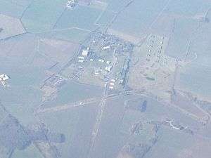
Aerial view of RAF Faldingworth (March 2016) | |||||||||||||||||||
| IATA: none – ICAO: none | |||||||||||||||||||
| Summary | |||||||||||||||||||
| Airport type | Military | ||||||||||||||||||
| Owner | Ministry of Defence | ||||||||||||||||||
| Operator | Royal Air Force | ||||||||||||||||||
| Location | Faldingworth, Lincolnshire | ||||||||||||||||||
| Built | 1943 | ||||||||||||||||||
| In use | 1943-1972 | ||||||||||||||||||
| Elevation AMSL | 49 ft / 15 m | ||||||||||||||||||
| Coordinates | 53°20′58″N 000°27′23″W / 53.34944°N 0.45639°W | ||||||||||||||||||
| Map | |||||||||||||||||||
 RAF Faldingworth Location in Lincolnshire | |||||||||||||||||||
| Runways | |||||||||||||||||||
| |||||||||||||||||||
Royal Air Force Station Faldingworth or more simply RAF Faldingworth was a Royal Air Force station used during and after the Second World War. It was located close to the village of Faldingworth in Lincolnshire, England.
Development
By 1936 the RAF Expansion Scheme had overseen a period of rapid increases both in terms of aircraft operated and the development of new stations.[1]The Faldingworth site was one of several earmarked under the expansion programme.
As it developed, it made an increasingly dramatic imposition on the surrounding rural landscape[1]such as to the Lincolnshire Edge, a Jurassic limestone ridge, which forms the distinctive backbone of the county from Whitton on the Humber Estuary in the north, down to Grantham in the south. [1] It provides a continuous homogenous landscape of high quality agricultural land, with a number of local variations. To the west of the Edge, the gently undulating Trent Vale eventually flows into the moors and levels of Humberhead, draining to the Humber Estuary. [1] To the east there is a gentle transition into the Central Lincolnshire Vale between the Humber and Lincoln, while south of Lincoln the Edge is bounded by a narrow finger of Fenland, which follows the River Witham into Lincoln. [1] To the south, the Edge merges into the more undulating Kesteven Uplands. [1] Along the top of the Edge a series of airfields were developed, they lie within an open landscape, consisting of rectilinear fields and few boundaries. [1]
History
Faldingworth entered service life as Toft Grange decoy airfield and later as a satellite airfield of RAF Lindholme. Late in 1943 it became a satellite of RAF Ludford Magna. After the war the base was used for storage of weapons.
In 1957 the site became a nuclear weapons store for the RAF V bomber force. In times of crisis nuclear weapons from the site would be distributed to the nearby v-bomber airfields such as RAF Scampton, RAF Finningley and RAF Coningsby. With the transfer of the UK nuclear deterrent role to the Royal Navy's Resolution class submarines in 1968 the site was run down and finally de-activated in 1972.
In 1959 there was an oxygen production unit operating on the opposite side of the airfield to the nuclear weapons storage site. Two BA1D air separation units were operated on a 24-hour basis to provide a ready supply of breathable oxygen for the aircrew of the V bombers. At that time RAF Faldingworth was a satellite station of RAF Scampton.
Current Ordnance Survey maps show the remains of a typical wartime bomber airfield, with the former storage site overlaying the south-western part of the airfield, about 1.25 miles (2 km) east of Spridlington. There is a cluster of RAF-built housing north-east of the airfield area, sold to The Welbeck Estate Group in 1979 and a group of RAF buildings used as an industrial estate.
Operation units and aircraft
- No. 300 Polish Bomber Squadron (1944-1947) - Vickers Wellington X, Avro Lancaster I & III
- No. 305 Polish Bomber Squadron (1946-1947) - de Havilland Mosquito VI
Memorial
A memorial is now in place to them at the end of the main runway commemorating 300 (Polish) Squadron.
References
Citations
Bibliography
- Halpenny, B.B. Action Stations: Wartime Military Airfields of Lincolnshire and the East Midlands v. 2. Cambridge, Cambridgeshire, Patrick Stephens Ltd, 1981. ISBN 0-85059-484-7.
External links
| Wikimedia Commons has media related to RAF Faldingworth. |
Royal Air Force portal | ||
| Formations and units |  | |
| Branches and components | ||
| Reserve forces | ||
| Associated civil organizations | ||
| Equipment | ||
| Personnel | ||
| Appointments | ||
| Symbols and uniform | ||