RAF Birch
| RAF Birch USAAF Station 149  | |||||||||||
|---|---|---|---|---|---|---|---|---|---|---|---|
| Birch, Essex in England | |||||||||||
|
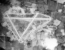
RAF Birch during World War II, September 1944. The fully completed airfield was essentially never used by the Allies. | |||||||||||
 RAF Birch Shown within Essex | |||||||||||
| Coordinates | 51°50′33″N 000°46′50″E / 51.84250°N 0.78056°ECoordinates: 51°50′33″N 000°46′50″E / 51.84250°N 0.78056°E | ||||||||||
| Type | Royal Air Force station | ||||||||||
| Site information | |||||||||||
| Owner | Air Ministry | ||||||||||
| Operator |
Royal Air Force United States Army Air Forces | ||||||||||
| Site history | |||||||||||
| Built | 1944 | ||||||||||
| In use | 1944-1945 | ||||||||||
| Airfield information | |||||||||||
| Elevation | 42 metres (138 ft) AMSL | ||||||||||
| |||||||||||
Royal Air Force Birch or more simply RAF Birch is a former Royal Air Force station in Essex, England. The airfield is located 2 mi (3.2 km) northeast of Tiptree; about 43 mi (69 km) northeast of London
Opened in 1942 it was used by both the Royal Air Force and United States Army Air Forces. During the war, it was used primarily as a reserve transport airfield. It was closed after the war, in late 1945.
Today, the remains of the airfield are located on private property and used as agricultural fields.
United States Army Air Forces use
Birch was known as USAAF Station AAF-149 for security reasons by the USAAF during the war, and by which it was referred to instead of location. Its USAAF Station Code was "BR".
Current use
With the facility released from military control, the airfield was returned to agricultural use.
Today, most of the concreted areas have been removed for hardcore, leaving single tracked farm roads along the main runway, one secondary, and parts of the perimeter track. Blind Lane (a public road) now runs along the other secondary (02/20) its original course having been taken when building the airfield. Some hardstanding is also used by Essex Council for garden waste composting, the main site being accessed via the main runway. A few loop hardstands remain intact off the remains of the single-tracked perimeter track along the north side of the airfield. However, other than these farm roads, there is little remaining of the wartime airfield that was never used, other than some ghostly disturbed areas in aerial photography of loop dispersal hardstands and the long since removed perimeter track.
See also
References
![]() This article incorporates public domain material from the Air Force Historical Research Agency website http://www.afhra.af.mil/.
This article incorporates public domain material from the Air Force Historical Research Agency website http://www.afhra.af.mil/.
Citations
Bibliography
- Freeman, Roger A. (1978) Airfields of the Eighth: Then and Now. After the Battle ISBN 0-900913-09-6
- Freeman, Roger A. (1991) The Mighty Eighth The Colour Record. Cassell & Co. ISBN 0-304-35708-1
- Maurer, Maurer (1983). Air Force Combat Units Of World War II. Maxwell AFB, Alabama: Office of Air Force History. ISBN 0-89201-092-4.
External links
| Wikimedia Commons has media related to RAF Birch. |
.svg.png)
Royal Air Force portal | ||
| Formations and units |  | |
| Branches and components | ||
| Reserve forces | ||
| Associated civil organizations | ||
| Equipment | ||
| Personnel | ||
| Appointments | ||
| Symbols and uniform | ||