Røyken Municipality
- This is about the municipality. For the village, see Røyken (village).
| Røyken kommune | |||
|---|---|---|---|
| Municipality | |||
 | |||
| |||
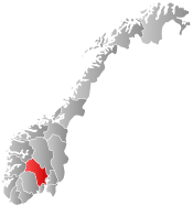
 Røyken within Buskerud | |||
| Coordinates: 59°44′1″N 10°25′44″E / 59.73361°N 10.42889°ECoordinates: 59°44′1″N 10°25′44″E / 59.73361°N 10.42889°E | |||
| Country | Norway | ||
| County | Buskerud | ||
| District | Lower Buskerud | ||
| Administrative centre | Midtbygda | ||
| Government | |||
| • Mayor (2003) | Rune Kjølstad (H) | ||
| Area | |||
| • Total | 113 km2 (44 sq mi) | ||
| • Land | 111 km2 (43 sq mi) | ||
| Area rank | 378 in Norway | ||
| Population (2014) | |||
| • Total | 20,621 | ||
| • Rank | 59 in Norway | ||
| • Density | 153/km2 (400/sq mi) | ||
| • Change (10 years) | 15.2 % | ||
| Demonym(s) | Røykenbøring[1] | ||
| Time zone | CET (UTC+1) | ||
| • Summer (DST) | CEST (UTC+2) | ||
| ISO 3166 code | NO-0627 | ||
| Official language form | Bokmål | ||
| Website |
www | ||
|
| |||

Røyken Municipality is a municipality in Buskerud County, Norway. The administrative centre of the municipality is the village of Midtbygda. The parish of Røken was established as a municipality on 1 January 1838 (see formannskapsdistrikt).
Oslo ATCC, the Area Control Center for the controlled airspace above Østlandet is located here.
General information
Name
The municipality (originally the parish) is named after the old Røyken farm (Norse Raukvin), since the first church was built there. The first element is raukr which means "pile, stack; mountain" and the last element is vin which means "meadow" or "pasture".
See also Røykenvik.
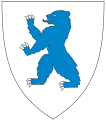
Coat-of-arms
The coat-of-arms is from modern times. They were granted on 15 December 1967. The figure shows a yellow fire on a blue background. It was chosen as a semi-canting symbol to represent smoke (which cannot be depicted in heraldry). The background for the motif is a common misunderstanding of the name as røyken the definite form of røyk meaning "smoke".[2][3]
Geography
Røyken is located south of Lier and Asker, on the northern part of the Hurum peninsula north of Hurum municipality. It lies between Oslofjord and Drammensfjord. It is connected to the eastern side of the Oslofjord via Hurum municipality and the Oslofjord Tunnel. The tunnel is 7.2 kilometres (4.5 mi) long and connects Hurumhalvøya to Akershus county.
The district includes large amounts of residential zones with beautiful sights of the sea. The administration is situated in the village of Midtbygda. The main population centers are the villages of Hyggen, Hallenskog, Nærsnes, Røyken, Slemmestad, Spikkestad, and Åros. Many people live in the northern part of Bødalen and its vicinities, which is a continuous residential area that continues throughout Asker and Bærum to Oslo.
Municipality Reform
As part of the municipality reform process instigated by Minister of Local Government Jan Tore Sanner the municipalities of Asker, Hurum and Røyken evaluated if they should merge into a new common municipality during the first half of 2016. A tentative agreement was reached and on 16 June 2016 the Municipal Council of Røyken approved the merger with Asker and Hurum with 24 votes for and 3 against.[4] The proposed merger date is 1 January 2020 and the new name will be Asker.[4]
Gallery
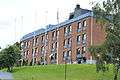 Røyken High School
 Odden Marina
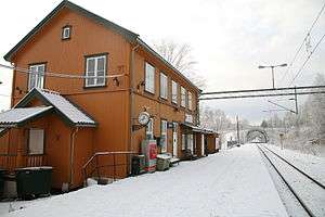 Røyken Rail Station
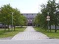 Røyken City Hall
 Røyken Church
References
- ↑ "Navn på steder og personer: Innbyggjarnamn" (in Norwegian). Språkrådet. Retrieved 2015-12-01.
- ↑ Norske Kommunevåpen (1990). "Nye kommunevåbener i Norden". Retrieved 2009-01-11.
- ↑ "Kommunevåpenet". Røyken kommune. Archived from the original on February 10, 2009. Retrieved 2009-01-11. (Norwegian)
- 1 2 "Røyken sier ja til sammenslåing" (in Norwegian). Røyken kommune. 2016-06-16. Retrieved 2016-06-16.
External links
 Media related to Røyken at Wikimedia Commons
 The dictionary definition of Røyken at Wiktionary
- Municipal fact sheet from Statistics Norway
 Buskerud travel guide from Wikivoyage