Rømskog
| Rømskog kommune | |||
|---|---|---|---|
| Municipality | |||
| |||
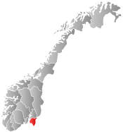
 Rømskog within Østfold | |||
| Coordinates: 59°42′52″N 11°48′31″E / 59.71444°N 11.80861°ECoordinates: 59°42′52″N 11°48′31″E / 59.71444°N 11.80861°E | |||
| Country | Norway | ||
| County | Østfold | ||
| District | Smaalenene | ||
| Administrative centre | Rømskog | ||
| Government | |||
| • Mayor (2007) | Nils Nilssen (Ap) | ||
| Area | |||
| • Total | 183 km2 (71 sq mi) | ||
| • Land | 159 km2 (61 sq mi) | ||
| Area rank | 340 in Norway | ||
| Population (2008) | |||
| • Total | 649 | ||
| • Rank | 420 in Norway | ||
| • Density | 4/km2 (10/sq mi) | ||
| • Change (10 years) | 4.5 % | ||
| Demonym(s) | Rømsking[1] | ||
| Time zone | CET (UTC+1) | ||
| • Summer (DST) | CEST (UTC+2) | ||
| ISO 3166 code | NO-0121 | ||
| Official language form | Bokmål | ||
| Website |
www | ||
|
| |||

Rømskog is a municipality in Østfold county, Norway. The administrative centre of the municipality is the village of Rømskog. The new municipality of Rømskog was separated from Rødenes on 1 January 1902.
Slavasshøgda is a hill in Rømskog and is the highest point in Østfold county at 336 metres (1,102 ft).
General information
Name
The Old Norse form of the name was Rymsskógr. The first element is the genitive case of the name of the lake Rymr (now Rømsjøen) and the last element is skógr which means "wood" or "forest". The meaning of the name Rymr is unknown.
Coat-of-arms
The coat-of-arms is from modern times. They were granted on 22 July 1983. The arms show a pair of silver logging tongs on a blue background. Since forestry is the main source of income for the municipality, it was considered an appropriate symbol.[2]
| Ancestry | Number |
|---|---|
| | 19 |
| | 11 |
References
- ↑ "Navn på steder og personer: Innbyggjarnamn" (in Norwegian). Språkrådet. Retrieved 2015-12-01.
- ↑ Norske Kommunevåpen (1990). "Nye kommunevåbener i Norden". Retrieved 2008-12-15.
- ↑ "Immigrants and Norwegian-born to immigrant parents, by immigration category, country background and percentages of the population". ssb.no. Retrieved 29 June 2015.
External links
 Media related to Rømskog at Wikimedia Commons
 The dictionary definition of Rømskog at Wiktionary
- Municipal fact sheet from Statistics Norway

Wikivoyage has a travel guide for Østfold.