Río Negro (Uruguay)
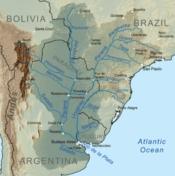
The Río Negro (Spanish pronunciation: [ˈri.o ˈneɣɾo], Black River) is the most important river in Uruguay.[1] It originates in the southern highlands of Brazil, just east of Bagé, and flows west across the entire width of Uruguay to the Uruguay River. The course of the Río Negro across Uruguay effectively divides the south of the country from the north. The Río Negro's principals tributaries are Yí River and Tacuarembó River.

The river is dammed near Paso de los Toros, creating the Rincón del Bonete Reservoir, also called the Gabriel Terra Reservoir or the Rio Negro Reservoir. With a surface area of about 420 square miles (1,100 km2), it is the largest reservoir in Uruguay and an installed capacity of 160 MW.[2]
Downstream from the Rincón del Bonete Reservoir, there are two more dams, the Baygorria Dam and the Constitución Dam at Palmar,[3] which generate hydroelectric power for Uruguay with 108 MW and 333 MW, respectively.[2]
The Río Negro's drainage basin size is about 69,700 square kilometres (26,900 sq mi).[1]
See also
References
- 1 2 "The Groundwater Resources of Uruguay" (PDF). International Association of Hydrological Sciences. Retrieved 12 August 2010.
- 1 2 "Negro River". Encyclopædia Britannica. Retrieved 12 August 2010.
- ↑ Page about the Constitution Dam at Palmar
External links
Coordinates: 33°24′S 58°22′W / 33.400°S 58.367°W