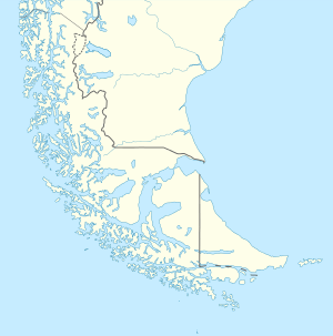
Río Grande, Tierra del Fuego
| Río Grande | |||
|---|---|---|---|
|
Río Grande | |||
| |||
 Río Grande | |||
| Coordinates: 53°47′S 67°42′W / 53.783°S 67.700°WCoordinates: 53°47′S 67°42′W / 53.783°S 67.700°W | |||
| Country |
| ||
| Province |
| ||
| Department | Río Grande | ||
| Established | July 11, 1921 | ||
| Area | |||
| • Total | 12,181 km2 (4,703 sq mi) | ||
| Elevation | 0 m (0 ft) | ||
| Population (2010 Census) | |||
| • Total | 67,038 | ||
| • Density | 5.5/km2 (14/sq mi) | ||
| Time zone | ART (UTC−3) | ||
| CPA Base | V 9420 | ||
| Area code(s) | +54 2964 | ||
| Climate | Cfc | ||
| Website | Official website | ||


Río Grande is a city in Argentina, on the north coast of the eastern part of the Isla Grande de Tierra del Fuego. It has a population of 67,038, and is the industrial capital of the Tierra del Fuego Province.
It is served by Hermes Quijada International Airport.
History
Sheep farming, as many other places in Patagonia, was the main impetus for population settlements beginning in the late 19th century.
Abundant rivers, the seacoast, and good pastures were some of the reasons that fueled population growth. Río Grande was founded on July 11, 1921, when the central government issued a decree recognising this locality as the "Agricultural Colony of Río Grande".
In the beginning, the land was subdivided among a few families, owning large estates until the agrarian reform of 1925. Cattle raising became one of the most important economic activities in the area.
To promote industrial development, Tierra del Fuego is excluded from VAT and federal income tax. As a result, several manufacturing companies, particularly those involving electronic products, have opened factories in this city. One of the most rapidly growing sectors is the production of laptops and netbooks. These products were totally imported until 2006 but by 2010, 42% of the Argentine market for these goods was supplied by firms established in Río Grande and Vicente López. Portfolio investments announced in 2011 plan the production of 6.9 million units in Tierra del Fuego Province, principally in Río Grande.[1]
The city's population has grown rapidly since 1980. Many people have relocated from the northern parts of Argentina and from other countries, such as Bolivia, to work in factories that offer higher wages than other parts of Argentina.
Climate
Rio Grande's climate is strongly influenced by the ocean: generally quite cool, and sometimes very windy. It has a subpolar oceanic climate (Köppen Cfc) with cool temperatures year round. Temperatures in the warmest months, January and February average 11 °C (51.8 °F) while temperatures in the coolest month average 0 °C (32.0 °F).[2] With a mean temperature of −0.3 °C (31.5 °F) in the coldest month, Río Grande has the coldest mean monthly temperature amongst cities in Argentina.[3] Precipitation is low at around 330 millimetres (13 in). Also, due to its latitude, the length of the day varies tremendously across the year. Winter days can have as few as seven hours of sunlight, while summer days stretch to twenty hours. Frost occurs throughout the year, and winter temperatures can remain below freezing for relatively long periods of time.[4] As such, the frost free period is very short with the first date of frost being February 23 and the last date of frost being November 22.[5] During the summer, conditions are generally very windy and cloudy, and nights remain cold. Freak snowfalls can occur even in midsummer. The highest recorded temperature was 27.1 °C (80.8 °F) on January 30, 1975 while the lowest recorded temperature was −22.2 °C (−8.0 °F).[4][5]
| Climate data for Rio Grande, Argentina (extremes 1941–1950 and 1970–present)[lower-alpha 1] | |||||||||||||
|---|---|---|---|---|---|---|---|---|---|---|---|---|---|
| Month | Jan | Feb | Mar | Apr | May | Jun | Jul | Aug | Sep | Oct | Nov | Dec | Year |
| Record high °C (°F) | 27.1 (80.8) |
27.0 (80.6) |
24.0 (75.2) |
23.0 (73.4) |
15.4 (59.7) |
11.1 (52) |
11.6 (52.9) |
12.8 (55) |
17.5 (63.5) |
21.0 (69.8) |
23.4 (74.1) |
24.8 (76.6) |
27.1 (80.8) |
| Average high °C (°F) | 16.2 (61.2) |
15.9 (60.6) |
13.6 (56.5) |
10.2 (50.4) |
6.3 (43.3) |
3.0 (37.4) |
2.9 (37.2) |
5.1 (41.2) |
8.5 (47.3) |
11.5 (52.7) |
13.8 (56.8) |
15.4 (59.7) |
10.2 (50.4) |
| Daily mean °C (°F) | 11.0 (51.8) |
10.4 (50.7) |
8.0 (46.4) |
5.2 (41.4) |
2.5 (36.5) |
0.0 (32) |
−0.2 (31.6) |
1.2 (34.2) |
3.4 (38.1) |
6.3 (43.3) |
8.6 (47.5) |
10.1 (50.2) |
5.5 (41.9) |
| Average low °C (°F) | 5.6 (42.1) |
5.3 (41.5) |
3.3 (37.9) |
1.1 (34) |
−0.9 (30.4) |
−3.0 (26.6) |
−2.6 (27.3) |
−1.9 (28.6) |
−0.4 (31.3) |
1.7 (35.1) |
3.4 (38.1) |
4.8 (40.6) |
1.4 (34.5) |
| Record low °C (°F) | −2.8 (27) |
−4.0 (24.8) |
−8.2 (17.2) |
−8.3 (17.1) |
−13.1 (8.4) |
−14.2 (6.4) |
−22.2 (−8) |
−14.9 (5.2) |
−9.9 (14.2) |
−8.2 (17.2) |
−5.7 (21.7) |
−3.4 (25.9) |
−22.2 (−8) |
| Average precipitation mm (inches) | 33.4 (1.315) |
28.7 (1.13) |
27.3 (1.075) |
33.2 (1.307) |
39.4 (1.551) |
25.2 (0.992) |
25.5 (1.004) |
21.5 (0.846) |
16.4 (0.646) |
18.5 (0.728) |
29.0 (1.142) |
32.8 (1.291) |
330.9 (13.028) |
| Average precipitation days | 14 | 12 | 10 | 11 | 12 | 8 | 7 | 7 | 7 | 8 | 10 | 11 | 117 |
| Average relative humidity (%) | 69 | 71 | 75 | 80 | 85 | 86 | 86 | 83 | 76 | 70 | 65 | 66 | 76 |
| Mean monthly sunshine hours | 170.5 | 175.2 | 155.0 | 114.0 | 77.5 | 84.0 | 86.8 | 114.7 | 147.0 | 186.0 | 186.0 | 192.2 | 1,688.9 |
| Percent possible sunshine | 33 | 43 | 40 | 36 | 29 | 37 | 35 | 39 | 42 | 44 | 39 | 36 | 37.8 |
| Source #1: Servicio Meteorologico Nacional[2] | |||||||||||||
| Source #2: Secretaria de Mineria (extremes and sun 1941–1950 and 1971–1990),[4] Oficina de Riesgo Agropecuario (extremes 1970–present)[5] | |||||||||||||
See also
References
- ↑ "En 2012 más de la mitad de las computadoras vendidas en el país serán nacionales". iProfesional.com.
- 1 2 "Datos Estadísticos (Período 1981-1990)" (in Spanish). Servicio Meteorologico Nacional. Retrieved March 31, 2013.
- ↑ "Datos extremos en el país y en el mundo" (in Spanish). Servicio Meteorológico Nacional. Retrieved July 12, 2015.
- 1 2 3 "Provincia de Tierra del Fuego - Clima Y Meteorologia: Datos Meteorologicos Y Pluviometicos" (in Spanish). Secretaria de Mineria de la Nacion (Argentina). Archived from the original on January 11, 2015. Retrieved April 7, 2013.
- 1 2 3 "Rio Grande, Tierra del Fuego". Estadísticas meteorológicas decadiales (in Spanish). Oficina de Riesgo Agropecuario. Retrieved July 12, 2015.
Notes
- ↑ The record highs and lows are based on the Secretaria de Mineria link for the period 1941–1950 and from 1971–1990 while records beyond 1970 come from the Oficina de Riesgo Agropecuario link since it only covers from 1970–present. When these 2 sources are used together, the record highs and lows are from the periods 1941–1950 and from 1970–present
Gallery
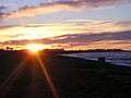 Río Grande at sunset
 Argentine Navy MB326 monument
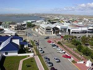
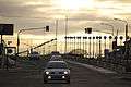 San Martín Avenue
External links
- Government website (Spanish)