Jejudo
| Native name: 제주도 Nickname: Sammu-samda-do = Island of no three kinds and many three kinds' | |
|---|---|
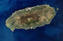 Image of Jejudo | |
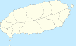 Map of Jejudo | |
| Geography | |
| Location | East Asia |
| Archipelago | Jeju |
| Area | 1,848 km2 (714 sq mi) |
| Length | 73 km (45.4 mi) |
| Width | 31 km (19.3 mi) |
| Highest elevation | 1,950 m (6,400 ft) |
| Highest point | Hallasan |
| Administration | |
|
South Korea | |
| Special Autonomous Province | Jeju Special Autonomous Province |
| Largest settlement | Jeju City (pop. 408,364) |
| Demographics | |
| Population | 583,284 |
| Pop. density | 316 /km2 (818 /sq mi) |
| Ethnic groups | Korean |
| Jejudo | |
| Hangul | 제주도 |
|---|---|
| Hanja | 濟州島 |
| Revised Romanization | Jejudo |
| McCune–Reischauer | Chejudo |
Jejudo (also known as Jeju Island) is the largest island off the coast of the Korean Peninsula, and the main island of Jeju Province of South Korea. The island lies in the Korea Strait, southwest of South Jeolla Province. The island contains the natural World Heritage Site Jeju Volcanic Island and Lava Tubes.[1] Jejudo has a temperate climate; even in winter, the temperature rarely falls below 0 °C (32 °F).
History
Historical names
Historically, the island has been called by many different names including:
- Doi (Hangul: 도이 , hanja: 島夷, literally "Island barbarian")
- Dongyeongju (Hangul: 동영주 ; hanja: 東瀛州)
- Juho (Hangul: 주호 , hanja: 州胡)
- Tammora (탐모라, 耽牟羅)
- Seomra (섭라, 涉羅)
- Tangna (탁라, 乇羅)
- Tamna (탐라, 耽羅)
- Quelpart,[2][3] Quelparte[4] or Quelpaert Island[5]
- Joonwonhado (준원하도, 준원下島 meaning southern part of peninsula)
- Taekseungnido (Hangul: 택승리도 , meaning the peaceful hot island in Joseon)
Island of no three kinds, and many three kindsThis means it was originally labeled the island of triple abundance: Wind, stones, and women, and then added to its reputation the fact it does not have beggars, thieves, or locked gates. [6]
Before the Japanese annexation in 1910, the island was usually known as Quelpart to Europeans. The name apparently came from the first European ship to spot the island, the Dutch Quelpaert, which sighted it after being blown off course on its way to the Dutch trading base in Nagasaki, Japan, from Taiwan (then the Dutch colony of Formosa).
"According to Korean records, a fleet of seventy pirate craft attacked Quelpart Island and adjacent parts of the Korean peninsula in 1555."[7]
When Korea was annexed by Japan in 1910, Jeju then became known as Saishū, which is the Japanese reading of the hanja for Jeju.
Before 2000, when the Seoul government established the official Revised Romanization of Korean, Jejudo was spelled Cheju-do. Almost all written references to the island before that use that spelling.
Jeju Uprising
From April 3, 1948 to May 1949, the South Korean government conducted a brutal anticommunist campaign to suppress an attempted uprising on the island.[8][9] The main cause for the rebellion was the election scheduled for May 10, 1948, designed by the United Nations Temporary Commission on Korea (UNTCOK) to create a new government for all of Korea. The elections were only planned for the south of the country, the half of the peninsula under UNTCOK control. Fearing that the elections would further reinforce division, guerrilla fighters for the South Korean Labor party (SKLP) reacted violently, attacking local police and rightist youth groups stationed on Jeju Island.[9][10]
Though atrocities were committed by both sides, the methods used by the South Korean government to suppress the rebels were especially cruel.[9][10][11] On one occasion, American soldiers discovered the bodies of ninety-seven men, women, and children, killed at the hand of government forces. On another, American soldiers caught police in the act of carrying out a gruesome execution of seventy-six villagers, including women and children.[9]
In the end, between 14,00 and 30,000 people died as a result of the rebellion, or up to 10% of the island’s total population.[9][11] Some 40,000 others fled to Japan to escape the fighting.[10][12] In the decades after the uprising, memory of the event was brutally suppressed by the government through strict punishment.[11] Only in 2006, more than 60 years after the rebellion, did the Korean government finally apologize for its role in the killings. Although the government simultaneously promised reparations, as of 2010, nothing had been done to this end.[13]
In 2008, bodies of victims of a massacre were discovered in a mass grave near Jeju International Airport.[14]
Process of formation
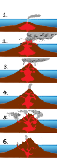
The adjacent picture shows formation processes of Jeju step by step.
- Step 1: About 1.2 million years ago, magma formed in the sea had begun to erupt.
- Step 2: About 700 thousand years ago, an island had been formed with volcanism.
※ After step 2 volcanic antivity had finished, there was no volcanism for about 100 thousand years.
- Step 3: About 300 thousand years ago, a coastline had been formed by volcanism restarted.
- Step 4: About 100 thousand years ago, there had been volcanically active and Halla Mountain had been formed.
- Step 5: About 25 thousand years ago, lateral eruptions around Halla Mountain left multiple oreum (smaller 'parasitic' cones on the flanks of the primary cone).
- Step 6: Volcanism has stopped and Jeju island has been formed from prolonged weathering and erosion.[15]
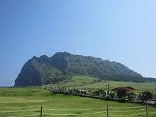
Geography
Jejudo is a volcanic island, dominated by Hallasan: a volcano 1,950 metres (6,400 ft) high and the highest mountain in South Korea. The island measures approximately 73 kilometres (45 mi) across, east to west, and 41 kilometres (25 mi) from north to south.[16]
The island was created entirely from volcanic eruptions approximately 2 million years ago, during the time period extending from the Tertiary to the beginning of the Quaternary period, and consists chiefly of basalt and lava. The eruptions took place in the Cenozoic era. It has a humid subtropical climate, warmer than that of the rest of Korea, with four distinct weather seasons. Winters are cool and dry while summers are hot, humid, and sometimes rainy.
An area covering about 12% (224 square kilometres or 86 square miles) of Jejudo is known as Gotjawal Forest.[17] This area remained uncultivated until the 21st century, as its base of ʻAʻā lava made it difficult to develop for agriculture. Because this forest remained pristine for so long, it has a unique ecology.[18]
The forest is the main source of groundwater and thus the main water source for the half million people of the island, because rainwater penetrates directly into the aquifer through the cracks of the ʻAʻā lava under the forest. Gotjawal forest is considered an internationally important wetland under the Ramsar Convention by some researchers[19] because it is the habitat of unique species of plants and is the main source of water for the residents, although to date it has not been declared a Ramsar site.[20]
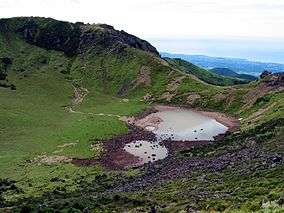 Baengnokdam in Hallasan
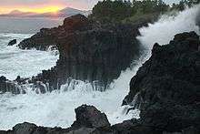 Waves crashing on Jeju seashore
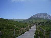 Halla Mountain in Jeju
Climate
| Climate data for Jeju City, Jejudo (1981–2010) | |||||||||||||
|---|---|---|---|---|---|---|---|---|---|---|---|---|---|
| Month | Jan | Feb | Mar | Apr | May | Jun | Jul | Aug | Sep | Oct | Nov | Dec | Year |
| Average high °C (°F) | 8.3 (46.9) |
9.4 (48.9) |
12.8 (55) |
17.5 (63.5) |
21.6 (70.9) |
24.8 (76.6) |
29.0 (84.2) |
29.8 (85.6) |
25.8 (78.4) |
21.3 (70.3) |
16.0 (60.8) |
11.0 (51.8) |
18.9 (66) |
| Daily mean °C (°F) | 5.7 (42.3) |
6.4 (43.5) |
9.4 (48.9) |
13.8 (56.8) |
17.8 (64) |
21.5 (70.7) |
25.8 (78.4) |
26.8 (80.2) |
23.0 (73.4) |
18.2 (64.8) |
12.8 (55) |
8.1 (46.6) |
15.8 (60.4) |
| Average low °C (°F) | 3.2 (37.8) |
3.6 (38.5) |
6.1 (43) |
10.2 (50.4) |
14.4 (57.9) |
18.7 (65.7) |
23.3 (73.9) |
24.3 (75.7) |
20.4 (68.7) |
15.1 (59.2) |
9.8 (49.6) |
5.3 (41.5) |
12.9 (55.2) |
| Average precipitation mm (inches) | 65.2 (2.567) |
62.6 (2.465) |
88.6 (3.488) |
89.6 (3.528) |
96.4 (3.795) |
181.4 (7.142) |
239.9 (9.445) |
262.5 (10.335) |
221.6 (8.724) |
80.3 (3.161) |
61.9 (2.437) |
47.7 (1.878) |
1,497.6 (58.961) |
| Average precipitation days (≥ 0.1 mm) | 12.6 | 10.3 | 11.2 | 10.0 | 10.4 | 11.8 | 12.5 | 13.5 | 10.8 | 7.0 | 9.3 | 10.8 | 130.2 |
| Average relative humidity (%) | 65.3 | 64.9 | 64.9 | 66.5 | 70.4 | 76.8 | 78.3 | 76.5 | 73.7 | 66.9 | 65.1 | 65.1 | 69.6 |
| Mean monthly sunshine hours | 70.4 | 105.4 | 158.9 | 194.4 | 211.9 | 170.9 | 195.6 | 195.6 | 161.7 | 178.5 | 126.0 | 84.8 | 1,854.1 |
| Source: Korea Meteorological Administration[21] | |||||||||||||
| Climate data for Seogwipo-si, Jejudo (1981–2010) | |||||||||||||
|---|---|---|---|---|---|---|---|---|---|---|---|---|---|
| Month | Jan | Feb | Mar | Apr | May | Jun | Jul | Aug | Sep | Oct | Nov | Dec | Year |
| Average high °C (°F) | 10.7 (51.3) |
11.6 (52.9) |
14.4 (57.9) |
18.5 (65.3) |
22.0 (71.6) |
24.6 (76.3) |
28.3 (82.9) |
30.1 (86.2) |
27.4 (81.3) |
23.4 (74.1) |
18.2 (64.8) |
13.2 (55.8) |
20.2 (68.4) |
| Daily mean °C (°F) | 6.8 (44.2) |
7.8 (46) |
10.6 (51.1) |
14.8 (58.6) |
18.6 (65.5) |
21.7 (71.1) |
25.6 (78.1) |
27.1 (80.8) |
23.9 (75) |
19.3 (66.7) |
14.1 (57.4) |
9.3 (48.7) |
16.6 (61.9) |
| Average low °C (°F) | 3.6 (38.5) |
4.4 (39.9) |
7.1 (44.8) |
11.3 (52.3) |
15.3 (59.5) |
19.2 (66.6) |
23.5 (74.3) |
24.6 (76.3) |
21.1 (70) |
15.9 (60.6) |
10.6 (51.1) |
5.9 (42.6) |
13.5 (56.3) |
| Average precipitation mm (inches) | 61.0 (2.402) |
77.1 (3.035) |
131.2 (5.165) |
174.9 (6.886) |
205.8 (8.102) |
276.9 (10.902) |
309.8 (12.197) |
291.6 (11.48) |
196.6 (7.74) |
81.6 (3.213) |
71.4 (2.811) |
45.1 (1.776) |
1,923 (75.709) |
| Average precipitation days (≥ 0.1 mm) | 10.3 | 9.5 | 11.0 | 10.5 | 10.7 | 12.9 | 14.3 | 14.2 | 10.3 | 6.1 | 7.4 | 8.1 | 125.3 |
| Average relative humidity (%) | 62.8 | 62.1 | 62.4 | 64.5 | 69.9 | 78.2 | 84.1 | 79.0 | 72.5 | 63.9 | 63.2 | 62.2 | 68.7 |
| Mean monthly sunshine hours | 152.2 | 152.6 | 174.0 | 190.9 | 199.0 | 144.2 | 142.1 | 184.2 | 176.1 | 207.1 | 170.5 | 161.8 | 2,054.7 |
| Source: Korea Meteorological Administration[22] | |||||||||||||
| Climate data for Seongsan-eup, Jejudo (1981–2010) | |||||||||||||
|---|---|---|---|---|---|---|---|---|---|---|---|---|---|
| Month | Jan | Feb | Mar | Apr | May | Jun | Jul | Aug | Sep | Oct | Nov | Dec | Year |
| Average high °C (°F) | 9.0 (48.2) |
10.2 (50.4) |
13.4 (56.1) |
17.8 (64) |
21.6 (70.9) |
24.2 (75.6) |
27.9 (82.2) |
29.5 (85.1) |
26.5 (79.7) |
22.0 (71.6) |
16.6 (61.9) |
11.4 (52.5) |
19.2 (66.6) |
| Daily mean °C (°F) | 5.4 (41.7) |
6.2 (43.2) |
9.3 (48.7) |
13.6 (56.5) |
17.5 (63.5) |
20.8 (69.4) |
24.9 (76.8) |
26.3 (79.3) |
23.1 (73.6) |
18.0 (64.4) |
12.5 (54.5) |
7.6 (45.7) |
15.4 (59.7) |
| Average low °C (°F) | 2.0 (35.6) |
2.4 (36.3) |
5.2 (41.4) |
9.2 (48.6) |
13.5 (56.3) |
17.6 (63.7) |
22.4 (72.3) |
23.6 (74.5) |
20.2 (68.4) |
14.2 (57.6) |
8.4 (47.1) |
3.9 (39) |
11.9 (53.4) |
| Average precipitation mm (inches) | 83.2 (3.276) |
69.7 (2.744) |
142.2 (5.598) |
150.1 (5.909) |
177.7 (6.996) |
223.7 (8.807) |
283.2 (11.15) |
360.6 (14.197) |
228.4 (8.992) |
90.8 (3.575) |
85.1 (3.35) |
72.0 (2.835) |
1,966.8 (77.433) |
| Average precipitation days (≥ 0.1 mm) | 11.1 | 9.1 | 10.9 | 9.1 | 9.4 | 12.4 | 13.0 | 13.6 | 9.8 | 5.8 | 7.7 | 8.9 | 120.8 |
| Average relative humidity (%) | 67.5 | 65.1 | 65.0 | 66.7 | 71.4 | 81.1 | 84.4 | 80.6 | 75.3 | 68.4 | 67.8 | 67.6 | 71.7 |
| Mean monthly sunshine hours | 122.5 | 146.9 | 170.1 | 192.9 | 205.3 | 145.6 | 157.4 | 173.4 | 157.2 | 187.8 | 155.5 | 130.3 | 1,944.7 |
| Source: Korea Meteorological Administration[23] | |||||||||||||
| Climate data for Gosan-ri, Jejudo (1981–2010) | |||||||||||||
|---|---|---|---|---|---|---|---|---|---|---|---|---|---|
| Month | Jan | Feb | Mar | Apr | May | Jun | Jul | Aug | Sep | Oct | Nov | Dec | Year |
| Average high °C (°F) | 8.6 (47.5) |
9.4 (48.9) |
12.3 (54.1) |
16.5 (61.7) |
20.0 (68) |
23.4 (74.1) |
27.3 (81.1) |
29.1 (84.4) |
26.0 (78.8) |
21.2 (70.2) |
16.2 (61.2) |
11.2 (52.2) |
18.4 (65.1) |
| Daily mean °C (°F) | 6.2 (43.2) |
6.7 (44.1) |
9.3 (48.7) |
13.3 (55.9) |
16.8 (62.2) |
20.6 (69.1) |
24.7 (76.5) |
26.2 (79.2) |
23.1 (73.6) |
18.3 (64.9) |
13.3 (55.9) |
8.6 (47.5) |
15.6 (60.1) |
| Average low °C (°F) | 3.8 (38.8) |
4.2 (39.6) |
6.5 (43.7) |
10.4 (50.7) |
14.2 (57.6) |
18.3 (64.9) |
22.7 (72.9) |
23.9 (75) |
20.6 (69.1) |
15.7 (60.3) |
10.7 (51.3) |
6.1 (43) |
13.1 (55.6) |
| Average precipitation mm (inches) | 43.9 (1.728) |
46.9 (1.846) |
75.8 (2.984) |
86.4 (3.402) |
110.2 (4.339) |
148.7 (5.854) |
178.0 (7.008) |
201.8 (7.945) |
116.2 (4.575) |
45.7 (1.799) |
57.4 (2.26) |
31.7 (1.248) |
1,142.8 (44.992) |
| Average precipitation days (≥ 0.1 mm) | 11.4 | 9.1 | 10.9 | 9.3 | 10.1 | 11.8 | 11.9 | 13.4 | 9.3 | 6.1 | 8.0 | 9.7 | 121 |
| Average relative humidity (%) | 67.0 | 68.4 | 69.5 | 73.2 | 79.5 | 85.1 | 88.4 | 83.2 | 77.2 | 69.0 | 67.1 | 66.0 | 74.5 |
| Mean monthly sunshine hours | 90.9 | 126.5 | 167.0 | 196.3 | 201.6 | 158.0 | 176.6 | 215.5 | 187.8 | 207.2 | 153.6 | 108.4 | 1,989.2 |
| Source: Korea Meteorological Administration[24] | |||||||||||||
| Climate data for Witse Oreum, Jejudo (2003–2009, elevation 1,672m) | |||||||||||||
|---|---|---|---|---|---|---|---|---|---|---|---|---|---|
| Month | Jan | Feb | Mar | Apr | May | Jun | Jul | Aug | Sep | Oct | Nov | Dec | Year |
| Average high °C (°F) | −1.6 (29.1) |
0.9 (33.6) |
3.4 (38.1) |
10.0 (50) |
14.9 (58.8) |
18.1 (64.6) |
20.3 (68.5) |
20.6 (69.1) |
18.1 (64.6) |
13.2 (55.8) |
6.8 (44.2) |
0.0 (32) |
10.4 (50.7) |
| Daily mean °C (°F) | −5.9 (21.4) |
−3.5 (25.7) |
−0.8 (30.6) |
5.2 (41.4) |
10.3 (50.5) |
14.0 (57.2) |
17.4 (63.3) |
17.4 (63.3) |
14.2 (57.6) |
8.2 (46.8) |
2.2 (36) |
−3.5 (25.7) |
6.4 (43.5) |
| Average low °C (°F) | −9.1 (15.6) |
−7.5 (18.5) |
−5.1 (22.8) |
0.7 (33.3) |
5.7 (42.3) |
10.4 (50.7) |
14.7 (58.5) |
14.5 (58.1) |
11.0 (51.8) |
4.3 (39.7) |
−0.9 (30.4) |
−6.6 (20.1) |
2.7 (36.9) |
| Average precipitation mm (inches) | 46.9 (1.846) |
128.0 (5.039) |
301.2 (11.858) |
426.1 (16.776) |
653.1 (25.713) |
651.9 (25.665) |
742.3 (29.224) |
836.4 (32.929) |
526.7 (20.736) |
126.5 (4.98) |
165.8 (6.528) |
64.6 (2.543) |
4,669.4 (183.835) |
| Source: Jeju Regional Meteorological Administration[25] | |||||||||||||
Unusual weather event
In January 2016, a cold wave affected the region. Snow and frigid weather forced the cancellation of 1,200 flights on Jejudo, stranding approximately 90,300 passengers.[26]
Places of interest
- Manjanggul Lava Tube, 8 km long with a 1 km publicly accessible portion
- Seongsan Ilchulbong or "Sunrise Peak," a volcanic tuff cone and crater
- Mount Hallasan, the island's central dominant peak
- Seongeup Folk Village
- Jeju Teddy Bear Museum
- Jeju Loveland, a sex themed sculpture park
Utilities
The island's power-grid is connected to mainland plants by the HVDC Haenam–Cheju, and electricity is also provided by generators located on the island. As of 2001, there were four power plants on Jeju, with more under planning and construction. The most notable of these are the gas-fired generators of Jeju Thermal Power Plant, located in Jeju City. The present-day generators of this plant were constructed from 1982 onwards, replacing earlier structures that dated from 1968.[27] As elsewhere in Korea, the power supply is overseen by the Korea Electric Power Corporation, or KEPCO.
In February 2012, the governor of the state of Hawaii (USA), Neil Abercrombie, and the director of the Electricity Market and Smart Grid Division at the Korea Ministry of Knowledge Economy, Choi Kyu-Chong, signed a letter of intent to share information about Smart Grid technology. The Jeju Smart Grid was initially installed in 6,000 homes in Gujwa-eup and is being expanded. South Korea is using the pilot program of the Smart Grid on Jejudo as the testing ground in order to implement a nationwide Smart Grid by 2030.[28]
Transportation
As of 2012, the Seoul – Jeju City air route is by a significant margin the world's busiest, with 10,156,000 passengers flown between the two cities that year.[29]
See also
- Jeju language
- Jeju Province
- Jeju Uprising
- Jeju City
- Jeju International Airport
- Alddreu Airfield
- Jeju black cattle, indigenous cattle breed
- Jeju horse, indigenous horse breed
References
- ↑ "Unesco names World Heritage sites". BBC News. June 28, 2007. Retrieved May 6, 2010.
- ↑ "The Island of Quelpart". JSTOR 198722.
- ↑ "Quelpart Island and Its People". JSTOR 208503.
- ↑ "The Queen of Quelparte".
- ↑ "The Name of Quelpaert Island".
- ↑ "Jeju Island Facts".
- ↑ Sansom, George (1961). A History of Japan, 1334–1615. Stanford University Press. p. 269. ISBN 0804705259.
- ↑ Hugh Deane (1999). The Korean War, 1945-1953. China Books&Periodicals, Inc. pp. 54–58.
- 1 2 3 4 5 Merrill, John (1980). "Cheju-do Rebellion". The Journal of Korean Studies: 139–197.
- 1 2 3 Deane, Hugh (1999). The Korean War 1945-1953. San Francisco: China Books and Periodicals Inc. pp. 54–58. ISBN 0-8351-2644-7.
- 1 2 3 Kim, Hun Joon (2014). The Massacre at Mt. Halla: Sixty Years of Truth Seeking in South Korea. Cornell University Press. pp. 13–41. ISBN 9780801452390.
- ↑ Hideko takayama in tokyo (June 19, 2000). "Ghosts Of Cheju". newsweek. Retrieved 2009-03-30.
- ↑ O, John Kie-Chiang (1999). "Korean Politics: The Quest for Democratization and Economic Development". Cornell University Press.
- ↑ Song Jung Hee, Islanders still mourn April 3 massacre, Jeju Weekly, March 3, 2010
- ↑ "제주특별자치도 자연환경생태정보시스템". nature.jeju.go.kr. Retrieved 2016-03-14.
- ↑ Map of Korea: Cheju Island The People's Korea. Accessed 8 July 2012
- ↑ Jeong, Gwang-jung, 2004, Gotjawal and the livelihood of Jeju's People, 2004, Jeju Educational College, V. 33, pp. 41–65. 정광중, 2004, 곶자왈과 제주인의 삶, 제주교육대학교 논문집. http://www.riss4u.net/link?id=A35499718, page 49
- ↑ Yim, Eun-young, 2007, Bryophyte Flora of Dongbaek-dongsan, Jeju-do, Cheju National University, M.A. thesis. 임은영, 2007, 제주도 동백동산의 선태식물상, 제주대학교 석사학위논문. http://www.riss4u.net/link?id=U10812496_003
- ↑ Jang, Yong-chang and Chanwon Lee, 2009, "Gotjawal Forest as an internationally important wetland," Journal of Korean Wetlands Studies, 2009, Vol 1.
- ↑ Ramsar site list at the Wayback Machine (archived January 14, 2009) Accessed June 2009
- ↑ "평년값자료(1981–2010) 제주(184)". Korea Meteorological Administration. Retrieved 2011-05-23.
- ↑ "평년값자료(1981–2010) 서귀포(189)". Korea Meteorological Administration. Retrieved 2011-05-23.
- ↑ "평년값자료(1981–2010) 성산(188)". Korea Meteorological Administration. Retrieved 2011-05-23.
- ↑ "평년값자료(1981–2010) 고산(185)". Korea Meteorological Administration. Retrieved 2011-05-23.
- ↑ "제주도상세기후특성집(2010) 윗세오름(871)". Jeju Regional Meteorological Administration. Retrieved 2010-11-30.
- ↑ Ap, Tiffany (January 25, 2016). "Deaths, travel disruption as bitter cold grips Asia". CNN. Retrieved January 25, 2016.
- ↑ "Jeju Thermal P/P". Korea Midland Power website. Archived from the original on June 16, 2005. Retrieved July 29, 2005.
- ↑ "Korea and Hawaii join forces in Smart Grid venture". The Jeju Weekly. Feb 24, 2012. Retrieved Mar 5, 2012.
- ↑ http://www.amadeus.com/web/amadeus/en_1A-corporate/Amadeus-Home/News-and-events/News/2013_04_17_300-world-super-routes-attract/1319560217161-Page-AMAD_DetailPpal?assetid=1319526516400&assettype=PressRelease_C
External links
-
 Media related to Jeju at Wikimedia Commons
Coordinates: 33°23′N 126°32′E / 33.38°N 126.53°E