Queen Street, Oxford
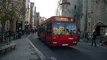
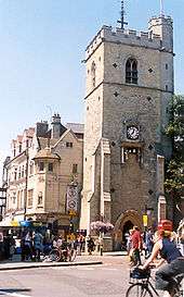
Queen Street is a pedestrianised shopping street in central Oxford, England.[1][2] It is one-way (west to east) for buses and taxis, two-way for cyclists outside main shopping hours, and forbidden for cars. It runs west from the centre of Oxford at Carfax. Here it adjoins Cornmarket Street to the north (also pedestrianised), the High Street continuing east, and St Aldate's to the south.
Halfway along on the north side is an entrance to the Clarendon Centre, a shopping centre. At the western end is Bonn Square, named after the German city of Bonn with which Oxford is twinned, and the Westgate Shopping Centre, where the old city gate to the west used to be located. New Inn Hall Street leads north from near here. Close by is the mound of Oxford Castle and the old Oxford Prison off New Road, which leads on to the west towards the Oxford railway station.
In the 13th century, the street was known as the Bailey due to its proximity with the castle.[2] Cattle were slaughtered and the meat sold here, so the street later became known as Butcher Row. The slaughtering of animals in the street was outlawed by the Oxford Mileways Act of 1771 and the butchers moved to the Covered Market. The street was then named Queen Street after Queen Charlotte, the wife of King George III, who both visited Oxford in 1785. There were many gabled and timer-framed buildings here until the late 19th century. Until 1932, there was a showroom for Morris Garages in the street. In 1970, the street was pedestrianised. The buildings have mostly been replaced with modern stores, such as the Marks & Spencer shop on the south side of the street, built in 1975–8.
Until 2009 many of the city's eastbound buses stopped here, and so it was frequently busy with people waiting for a bus.
References
- ↑ Queen Street, Old Oxford, UK.
- 1 2 Hibbert, Christopher, ed. (1988). "Abingdon Road". The Encyclopaedia of Oxford. Macmillan. p. 345. ISBN 0-333-39917-X.
Coordinates: 51°45′05″N 1°15′32″W / 51.7515°N 1.259°W