Quaternary glaciation
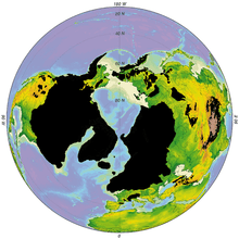
The Quaternary glaciation, also known as the Pleistocene glaciation or the current ice age, is a series of glacial events separated by interglacial events during the Quaternary period from 2.58 Ma (million years ago) to present.[1] During this period, ice sheets expanded, notably from out of Antarctica and Greenland, and fluctuating ice sheets occurred elsewhere (for example, the Laurentide ice sheet). The major effects of the ice age are erosion and deposition of material over large parts of the continents, modification of river systems, creation of millions of lakes, changes in sea level, development of pluvial lakes far from the ice margins, isostatic adjustment of the crust, and abnormal winds. It affected oceans, flooding, and biological communities. The ice sheets themselves, by raising the albedo, affect a major feedback on climate cooling.
Discovery
The Quaternary glaciation was the first ice age to be demonstrated in geology, and proved that these were possible. This was done over the 1700s and 1800s CE.
Over the last century, extensive field observations have provided evidence that continental glaciers covered large parts of Europe, North America, and Siberia. Maps of glacial features were compiled after many years of fieldwork by hundreds of geologists who mapped the location and orientation of drumlins, eskers, moraines, striations, and glacial stream channels. These maps revealed the extent of the ice sheets, the direction of flow, and the locations of systems of meltwater channels, and they allowed scientists to decipher a history of multiple advances and retreats of the ice. Even before the theory of worldwide glaciation was generally accepted, many observers recognized that more than a single advance and retreat of the ice had occurred.
Since then other, earlier ice ages have been identified, and the Quaternary event(s) constrained.
Description
The Quaternary glaciation is the last of five known glaciations during Earth's history. The other four are Huronian glaciation, Cryogenian, Andean-Saharan glaciation, and Karoo Ice Age.
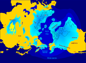
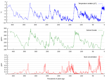
During the Quaternary Period, the total volume of land ice, sea level, and global temperature has fluctuated initially on 41,000- and more recently on 100,000-year time scales, as evidenced most clearly by ice cores for the past 800,000 years and marine sediment cores for the earlier period. Over the past 740,000 years there have been eight glacial cycles.[2] The entire Quaternary Period, starting 2.58 Ma, is referred to as an ice age because at least one permanent large ice sheet—Antarctica—has existed continuously. There is uncertainty over how much of Greenland was covered by ice during the previous and earlier interglacials. During the colder episodes—referred to as glacial periods—large ice sheets at least 4 km thick at their maximum also existed in Europe, North America, and Siberia. The shorter and warmer intervals between glacials are referred to as interglacials.
Currently, Earth is in an interglacial period, which marked the beginning of the Holocene epoch. The current interglacial began between 10,000 and 15,000 years ago, which caused the ice sheets from the last glacial period to begin to disappear. Remnants of these last glaciers, now occupying about 10% of the world's land surface, still exist in Greenland, Antarctica and mountainous regions. The retreat of glaciers since 1850 is largely a consequence of anthropogenic warming of the climate system during the period.[3][4]
During the glacial periods, the present (i.e. interglacial) hydrologic system was completely interrupted throughout large areas of the world and was considerably modified in others. Due to the volume of ice on land, sea level was approximately 120 meters lower than present.
Extensive evidence now shows that a number of periods of growth and retreat of continental glaciers occurred during the ice age, called glacials and interglacials. The interglacial periods of warm climate are represented by buried soil profiles, peat beds, and lake and stream deposits separating the unsorted, unstratified deposits of glacial debris.
Causes
No completely satisfactory theory has been proposed to account for Earth's history of glaciation. The cause of glaciation may be related to several simultaneous factors, such as astronomical cycles, atmospheric composition, plate tectonics, and ocean currents.[5]
Astronomical cycles
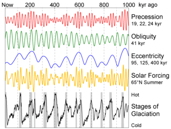
The role of Earth's orbital changes in controlling climate was first advanced by James Croll in the late 19th century.[6] Later, Milutin Milanković, a Serbian geophysicist, elaborated on the theory and calculated these irregularities in Earth's orbit could cause the climatic cycles known as Milankovitch cycles.[7] They are the result of the additive behavior of several types of cyclical changes in Earth's orbital properties.
Changes in the orbital eccentricity of Earth occur on a cycle of about 100,000 years.[8] The inclination, or tilt, of Earth's axis varies periodically between 22° and 24.5°.[8] (The tilt of Earth's axis is responsible for the seasons; the greater the tilt, the greater the contrast between summer and winter temperatures.) Changes in the tilt occur in a cycle 41,000 years long.[8] Precession of the equinoxes, or wobbles on Earth's spin axis, complete every 21,700 years. According to the Milankovitch theory, these factors cause a periodic cooling of Earth, with the coldest part in the cycle occurring about every 40,000 years. The main effect of the Milankovitch cycles is to change the contrast between the seasons, not the amount of solar heat Earth receives. These cycles within cycles predict that during maximum glacial advances, winter and summer temperatures are lower. The result is less ice melting than accumulating, and glaciers build up.
Milankovitch worked out the ideas of climatic cycles in the 1920s and 1930s, but it was not until the 1970s that sufficiently long and detailed chronology of the Quaternary temperature changes were worked out to test the theory adequately.[9] Studies of deep-sea cores, and the fossils contained in them indicate that the fluctuation of climate during the last few hundred thousand years is remarkably close to that predicted by Milankovitch.
A problem with the theory is that the astronomical cycles have been in existence for billions of years, but glaciation is a rare occurrence. Astronomical cycles correlate perfectly with glacial and interglacial periods, and their transitions, inside an ice age. Other factors such as the position of continents and the effects this has on Earth's oceanic currents, or long term fluctuations inside the core of the sun must also be involved that caused Earth's temperature to drop below a critical threshold and thus initiate the ice age in the first place. Once that occurs, Milankovitch cycles will act to force the planet in and out of glacial periods.
Atmospheric composition
One theory holds that decreases in atmospheric CO
2, an important greenhouse gas, started the long-term cooling trend that eventually led to glaciation. Recent studies of the CO
2 content of gas bubbles preserved in the Greenland ice cores lend support to this idea. The geochemical cycle of carbon indicates more than a 90% decrease in atmospheric CO
2 since the middle of the Mesozoic Era.[10] An analysis of CO
2 reconstructions from alkenone records shows that CO
2 in the atmosphere declined before and during Antarctic glaciation and supports a substantial CO
2 decrease as the primary cause of Antarctic glaciation.[11]
CO
2 levels also play an important role in the transitions between interglacials and glacials. High CO
2 contents correspond to warm interglacial periods, and low CO
2 to glacial periods. However, studies indicate that CO
2 may not be the primary cause of the interglacial-glacial transitions, but instead acts as a feedback.[12] The explanation for this observed CO
2 variation "remains a difficult attribution problem."[12]
Plate tectonics and ocean currents
An important component in the long-term temperature drop may be related to the positions of the continents, relative to the poles (but it cannot explain the rapid retreat and advances of glaciers).[13] This relation can control the circulation of the oceans and the atmosphere, affecting how ocean currents carry heat to high latitude. Throughout most of the geologic time, the North Pole appears to have been in a broad, open ocean that allowed major ocean currents to move unabated. Equatorial waters flowed into the polar regions, warming them with water from the more temperate latitudes. This unrestricted circulation produced mild, uniform climates that persisted throughout most of geologic time.
Throughout the Cenozoic Era, the large North American and South American continental plates moved westward from the Eurasian plate. This drift interlocked with the development of the Atlantic Ocean, trending north-south, with the North Pole in the small, nearly landlocked basin of the Arctic Ocean. The Isthmus of Panama developed at a convergent plate margin about 3 million years ago, and further separated oceanic circulation, closing the last strait, outside of the polar regions, that had connected the Pacific and Atlantic oceans.[14]
Effects
The presence of so much ice upon the continents had a profound effect upon almost every aspect of Earth's hydrologic system. The most obvious effects are the spectacular mountain scenery and other continental landscapes fashioned both by glacial erosion and deposition instead of running water. Entirely new landscapes covering millions of square kilometers were formed in a relatively short period of geologic time. In addition, the vast bodies of glacial ice affected Earth well beyond the glacier margins. Directly or indirectly, the effects of glaciation were felt in every part of the world.
Lakes
The Quaternary glaciation created more lakes than all other geologic processes combined. The reason is that a continental glacier completely disrupts the preglacial drainage system. The surface over which the glacier moved was scoured and eroded by the ice, leaving myriad closed, undrained depressions in the bedrock. These depressions filled with water and became lakes.
Very large lakes were created along the glacial margins. The ice on both North America and Europe was about 3,000 m (9,800 ft) thick near the centers of maximum accumulation, but it tapered toward the glacier margins. Ice weight caused crustal subsidence which was greatest beneath the thickest accumulation of ice. As the ice melted, rebound of the crust lagged behind, producing a regional slope toward the ice. This slope formed basins that have lasted for thousands of years. These basins became lakes or were invaded by the ocean. The Great Lakes[15] and the Baltic Sea of northern Europe[16][17] were formed primarily in this way.
Pluvial lakes
The climatic conditions that cause glaciation had an indirect effect on arid and semiarid regions far removed from the large ice sheets. The increased precipitation that fed the glaciers also increased the runoff of major rivers and intermittent streams, resulting in the growth and development of large pluvial lakes. Most pluvial lakes developed in relatively arid regions where there typically was insufficient rain to establish a drainage system to the sea. Instead, stream runoff in those areas flowed into closed basins and formed playa lakes. With increased rainfall, the playa lakes enlarged and overflowed. Pluvial lakes were most extensive during glacial periods. During interglacial stages, when less precipitation fell, the pluvial lakes shrank to form small salt flats.
Isostatic adjustment
Major isostatic adjustments of the lithosphere during the Quaternary glaciation were caused by the weight of the ice, which depressed the continents. In Canada, a large area around Hudson Bay was depressed below sea level, as was the area in Europe around the Baltic Sea. The land has been rebounding from these depressions since the ice melted. Some of these isostatic movements triggered large earthquakes in Scandinavia about 9,000 years ago. These earthquakes are unique in that they are not associated with plate tectonics.
Studies have shown that the uplift has taken place in two distinct stages. The initial uplift following deglaciation was rapid (called "elastic"), and took place as the ice was being unloaded. After this "elastic" phase, uplift proceed by "slow viscous flow" so the rate decreased exponentially after that. Today, typical uplift rates are of the order of 1 cm per year or less. In northern Europe, this is clearly shown by the GPS data obtained by the BIFROST GPS network.[18] Studies suggest that rebound will continue for about at least another 10,000 years. The total uplift from the end of deglaciation depends on the local ice load and could be several hundred meters near the center of rebound.
Winds
The presence of ice over so much of the continents greatly modified patterns of atmospheric circulation. Winds near the glacial margins were strong and persistent because of the abundance of dense, cold air coming off the glacier fields. These winds picked up and transported large quantities of loose, fine-grained sediment brought down by the glaciers. This dust accumulated as loess (wind-blown silt), forming irregular blankets over much of the Missouri River valley, central Europe, and northern China.
Sand dunes were much more widespread and active in many areas during the early Quaternary period. A good example is the Sand Hills region in Nebraska, USA, which covers an area of about 60,000 km2 (23,166 sq mi).[19] This region was a large, active dune field during the Pleistocene epoch, but today is largely stabilized by grass cover.[20][21]
Ocean currents
Thick glaciers were heavy enough to reach the sea bottom in several important areas, thus blocking the passage of ocean water and thereby affecting ocean currents. In addition to direct effects, this caused feedback effects as ocean currents contribute to global heat transfer.
Records of prior glaciation
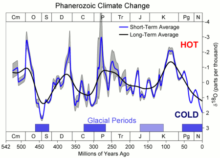
Glaciation has been a rare event in Earth's history,[22] but there is evidence of widespread glaciation during the late Paleozoic Era (200 to 300 Ma) and during late Precambrian (i.e. in the Neoproterozoic Era, 600 to 800 Ma).[23] Before the current ice age, which began 2 to 3 Ma, Earth's climate was typically mild and uniform for long periods of time. This climatic history is implied by the types of fossil plants and animals and by the characteristics of sediments preserved in the stratigraphic record.[24] There are, however, widespread glacial deposits, recording several major periods of ancient glaciation in various parts of the geologic record. Such evidence suggests major periods of glaciation prior to the current Quaternary glaciation.
One of the best documented records of pre-Quaternary glaciation, called the Karoo Ice Age, is found in the late Paleozoic rocks in South Africa, India, South America, Antarctica, and Australia. Exposures of ancient glacial deposits are numerous in these areas. Deposits of even older glacial sediment exist on every continent except South America. These indicate that two other periods of widespread glaciation occurred during the late Precambrian, producing the Snowball Earth during the Cryogenian Period.[25]
Next glacial period

In popular culture, there is often reference to "the next ice age".[26] Technically, because Earth is already in an ice age at present, this usually refers to the next glacial period (because the Earth is currently in an interglacial period).
In the 1970s a few paleoclimatologists were concerned with the possibility of global cooling, and suggested that the next glacial could be rapidly approaching. The previous interglacial periods seemed to have lasted about 10,000 years each; a report in 1972 assuming that the present interglacial period would be equally long concluded, "it is likely that the present-day warm epoch will terminate relatively soon if man does not intervene."[27] Since then, our understanding of the climate system has improved. It is known that not all interglacial periods are of the same length and that solar heating varies in a non-linear fashion forced by the Milankovitch orbital cycles (see Causes section above). At the same time, it is also known that greenhouse gases are increasing in concentration with each passing year. Based on the variations in solar heating and on the amount of CO
2 in the atmosphere, some calculations of future temperatures have been made. According to these estimates, the interglacial period Earth is in now may persist for another 50,000 years if CO
2 levels increase to 750 parts per million (ppm)[28] while the recent atmospheric concentration of CO
2 is about 407 ppm by volume.[29] If CO
2 drops instead to 210 ppm, then the next glacial period may only be 15,000 years away.[28]
Moreover, studies of seafloor sediments and ice cores from glaciers around the world, namely Greenland, indicate that climatic change is not smooth. Studies of isotopic composition of the ice cores indicate the change from warm to frigid temperatures can occur in a decade or two.[30] In addition, the ice cores show that an ice age is not uniformly cold, nor are interglacial periods uniformly warm (see also stadial). Analysis of ice cores of the entire thickness of the Greenland glacier shows that climate over the last 250,000 years has changed frequently and abruptly. The present interglacial period (the last 10,000 to 15,000 years) has been fairly stable and warm, but the previous one was interrupted by numerous frigid spells lasting hundreds of years. If the previous period was more typical than the present one, the period of stable climate in which humans flourished—inventing agriculture and thus civilization—may have been possible only because of a highly unusual period of stable temperature.[31]
References
- ↑ Gradstein, Felix; et al. (2004). A Geologic Time Scale 2004. New York: Cambridge University Press. p. 412. ISBN 978-0-521-78673-7.
- ↑ Augustin, Laurent; et al. (2004). "Eight glacial cycles from an Antarctic ice core". Nature. 429 (6992): 623–628. doi:10.1038/nature02599. PMID 15190344.
- ↑ http://www.nasa.gov/centers/goddard/news/topstory/2003/1023esuice.html NASA
- ↑ http://www.ipcc.ch/publications_and_data/ar4/wg1/en/spmsspm-direct-observations.html
- ↑ Why were there Ice Ages?
- ↑ Discovery of the Ice Age
- ↑ EO Library: Milutin Milankovitch Archived December 10, 2003, at the Wayback Machine.
- 1 2 3 Why do glaciations occur?
- ↑ EO Library: Milutin Milankovitch Page 3
- ↑ Atmospheric carbon dioxide linked with Mesozoic and early Cenozoic climate change : Abstract : Nature Geoscience
- ↑ Pagani, Mark; Matthew Huber, Zhonghui Liu, Steven M. Bohaty, Jorijntje Henderiks, Willem Sijp, Srinath Krishnan, Robert M. DeConto. 2011. The Role of Carbon Dioxide During the Onset of Antarctic Glaciation. Science Vol 334 p 1261-1264; December 2, 2011.
- 1 2 Joos, Fortunat; Prentice, I. Colin (2004). "A Paleo-Perspective on Changes in Atmospheric CO2 and Climate" (PDF). The Global Carbon Cycle: Integrating Humans, Climate, and the Natural World (PDF). Scope. 62. Washington D.C.: Island Press. pp. 165–186. Retrieved 2008-05-07.
- ↑ Glaciers and Glaciation Archived August 5, 2007, at the Wayback Machine.
- ↑ EO Newsroom: New Images - Panama: Isthmus that Changed the World Archived August 2, 2007, at the Wayback Machine.
- ↑ CVO Website - Glaciations and Ice Sheets
- ↑ FENNIA 2002
- ↑ Polish Geological Institute Archived March 15, 2008, at the Wayback Machine.
- ↑ Continuous GPS measurements of postglacial adjustment in Fennoscandia 1. Geodetic results
- ↑ EO Newsroom: New Images - Sand Hills, Nebraska Archived August 2, 2007, at the Wayback Machine.
- ↑ LiveScience.com Archived December 1, 2008, at the Wayback Machine.
- ↑ Nebraska Sand Hills
- ↑ Ice Ages- Illinois State Museum
- ↑ When have Ice Ages occurred?
- ↑ Our Changing Continent
- ↑ Geotimes - April 2003 - Snowball Earth
- ↑ Revkin, Andrew C. (2003-11-03). "When Will the Next Ice Age Begin?". The New York Times. Retrieved 2008-05-07.
- ↑ Berger, A.; Loutre, M. F. (2002-08-23). "An Exceptionally Long Interglacial Ahead?". Science. 297 (5585): 1287–1288. doi:10.1126/science.1076120. PMID 12193773.
- 1 2 Christiansen, Eric. Dynamic Earth. p. 441. ISBN 9781449659028.
- ↑ Tans, Pieter. "Trends in Atmospheric Carbon Dioxide – Mauna Loa". National Oceanic and Atmospheric Administration. Retrieved 2016-05-06.
- ↑ Abrupt Climate Change Paleo Perspective Story
- ↑ Richerson, Peter J.; Robert Boyd; Robert L. Bettinger (2001). "Was agriculture impossible during the Pleistocene but mandatory during the Holocene? A climate change hypothesis" (PDF). American Antiquity. 66 (3): 387–411. doi:10.2307/2694241. Retrieved 29 December 2015.
External links
| Look up glaciation in Wiktionary, the free dictionary. |
- Glaciers and Glaciation
- Pleistocene Glaciation and Diversion of the Missouri River in Northern Montana
- Correlation of late Pleistocene glaciation in the western United States with North Atlantic Heinrich events
- After the Ice Age: The Return of Life to Glaciated North America by E.C. Pielou
- Alaska's Glacier and Icefields
- Pleistocene glaciations(the last 2 millions years)
- IPCC's Palaeoclimate(pdf)
- Causes
| Quaternary |
|  | ||||||
|---|---|---|---|---|---|---|---|---|
| Carboniferous–Permian |
| |||||||
| Ordovician-Silurian |
| |||||||
| Ediacaran |
| |||||||
| Cryogenian | ||||||||
| Paleoproterozoic |
| |||||||
| Related topics | ||||||||
| Quaternary | ||
|---|---|---|
| Pleistocene | Holocene | |
| Early | Middle | Late | Preboreal | Boreal | Atlantic | Subboreal | Subatlantic | |