Quantico, Virginia
| Quantico, Virginia | |
|---|---|
| Town | |
| Town of Quantico | |
 Location in Prince William County and the state of Virginia. | |
| Coordinates: 38°31′19″N 77°17′23″W / 38.52194°N 77.28972°W | |
| Country |
|
| State |
|
| County |
|
| Area | |
| • Total | 0.1 sq mi (0.3 km2) |
| • Land | 0.1 sq mi (0.3 km2) |
| • Water | 0.0 sq mi (0.0 km2) |
| Elevation | 39 ft (12 m) |
| Population (2010) | |
| • Total | 480 |
| Time zone | Eastern (EST) (UTC−5) |
| • Summer (DST) | EDT (UTC−4) |
| ZIP code | 22134 |
| Area code(s) | 571, 703 |
| FIPS code | 51-65120[1] |
| GNIS feature ID | 1499925[2] |
| Website | townofquantico.org |
Quantico (formerly Potomac)[3] is a town in Prince William County, Virginia. As of the 2010 United States Census, Quantico had a population of 480.
Quantico is bordered by the U.S. military installation of Marine Corps Base Quantico on three sides and the Potomac River on the fourth. Quantico is located south of the mouth of Quantico Creek on the Potomac. The word Quantico is a derivation of the name of a Doeg village recorded by English colonists as Pamacocack.
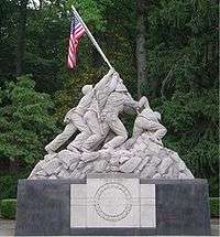
Quantico is the site of one of the largest U.S. Marine Corps bases in the world, MCB Quantico. The base is the site of the Marine Corps Combat Development Command and HMX-1 (the presidential helicopter squadron), Officer Candidate School and The Basic School. The United States Drug Enforcement Administration's training academy, the FBI Academy, the FBI Laboratory, the Naval Criminal Investigative Service and the Air Force Office of Special Investigations headquarters are on the base. A replica of the USMC War Memorial stands in the entrance to the base (the original is at the north end of Arlington National Cemetery).
As of 2013, the mayor is Kevin P. Brown.[4]
Geography
Quantico is at 38°31'19" North, 77°17'23" West (38.521871, −77.289757).[5] According to the United States Census Bureau, the town has a total area of 0.1 square miles (0.3 km2), of which, 0.1 square miles (0.3 km2) of it is land and none of the area is covered with water.
Climate
Quantico has a humid subtropical climate (Köppen climate classification Cfa).
| Climate data for Quantico, Virginia (1981–2010 normals) | |||||||||||||
|---|---|---|---|---|---|---|---|---|---|---|---|---|---|
| Month | Jan | Feb | Mar | Apr | May | Jun | Jul | Aug | Sep | Oct | Nov | Dec | Year |
| Average high °F (°C) | 44.2 (6.8) |
47.3 (8.5) |
56.1 (13.4) |
67.0 (19.4) |
75.1 (23.9) |
83.7 (28.7) |
87.5 (30.8) |
85.7 (29.8) |
78.9 (26.1) |
68.3 (20.2) |
57.8 (14.3) |
47.2 (8.4) |
66.7 (19.3) |
| Average low °F (°C) | 27.0 (−2.8) |
29.5 (−1.4) |
36.3 (2.4) |
45.9 (7.7) |
55.1 (12.8) |
64.8 (18.2) |
69.3 (20.7) |
68.1 (20.1) |
60.5 (15.8) |
48.3 (9.1) |
39.0 (3.9) |
30.5 (−0.8) |
48.0 (8.9) |
| Average precipitation inches (mm) | 2.88 (73.2) |
2.82 (71.6) |
3.74 (95) |
3.25 (82.6) |
3.77 (95.8) |
3.32 (84.3) |
3.82 (97) |
3.36 (85.3) |
3.88 (98.6) |
3.27 (83.1) |
3.81 (96.8) |
3.19 (81) |
41.11 (1,044.3) |
| Average snowfall inches (cm) | 4.0 (10.2) |
2.5 (6.4) |
1.3 (3.3) |
trace | 0 (0) |
0 (0) |
0 (0) |
0 (0) |
0 (0) |
0 (0) |
.5 (1.3) |
1.9 (4.8) |
10.2 (25.9) |
| Average precipitation days (≥ 0.01 in) | 10.1 | 8.9 | 10.9 | 10.3 | 11.8 | 9.7 | 10.4 | 7.3 | 7.9 | 8.0 | 9.5 | 10.0 | 114.8 |
| Average snowy days (≥ 0.1 in) | 2.2 | 1.8 | .7 | .1 | 0 | 0 | 0 | 0 | 0 | 0 | .2 | 1.1 | 6.1 |
| Source: NOAA[6] | |||||||||||||
Demographics
| Historical population | |||
|---|---|---|---|
| Census | Pop. | %± | |
| 1930 | 538 | — | |
| 1940 | 1,139 | 111.7% | |
| 1950 | 1,240 | 8.9% | |
| 1960 | 1,015 | −18.1% | |
| 1970 | 719 | −29.2% | |
| 1980 | 621 | −13.6% | |
| 1990 | 670 | 7.9% | |
| 2000 | 561 | −16.3% | |
| 2010 | 480 | −14.4% | |
| Est. 2015 | 537 | [7] | 11.9% |
As of the census[1] of 2000, there are 561 people, 295 households, and 107 families living in the town. The population density is 7,811.2 inhabitants per square mile (3,015.9/km2). There are 359 housing units at an average density of 4,998.6 per square mile (1,930.0/km2).
Racial composition
The racial makeup is 51.32% White, 20.32% African American, 10.16% Asian, 5.53% Hispanic or Latino, 0.36% Native American, 2.32% from other races, and 5.53% from two or more races.
Households
There are 295 households out of which 19.7% have children under the age of 18 living with them, 21.4% are married couples living together, 11.2% have a female householder with no husband present, and 63.4% are non-families. Of all households, 53.2% are made up of individuals and 9.2% have someone living alone who is 65 years of age or older. The average household size is 1.90 and the average family size is 3.02.
Ages
The population is spread out, with 20.9% under the age of 18, 11.6% from 18 to 24, 39.8% from 25 to 44, 19.4% from 45 to 64, and 8.4% who are 65 years of age or older. The median age is 35 years. For every 100 females there are 122.6 males. For every 100 females age 18 and over, there are 130.1 males.
Income
The median income for a male is $29,615 versus $23,125 for females. The per capita income for the town is $19,087. 21.4% of the population and 22.4% of families are below the poverty line. Out of the total population, 39.4% of those under the age of 18 and none of those 65 and older are living below the poverty line.
People from Quantico
- Robert L. Crawford, Jr., actor on Laramie
- Geof Isherwood
- Shelby Lynne, musician, singer, songwriter, producer, owner of Everso Records, actress
In popular culture
The FBI Academy in Quantico was the setting of fifteen episodes of The X-Files and several scenes from Thomas Harris' book The Silence of the Lambs and the film of the same name. Criminal Minds is based out of Quantico. The CBS drama CSI: Cyber is also set in Quantico. A new thriller series, Quantico, set at the FBI Academy premiered in 2015 on the ABC network. Major Jack Reacher makes numerous references to Quantico. Especially in Lee Childs novel "The Visitor"
See also
- Behavioral Analysis Unit
- Hostage Rescue Team
- Marine Corps Base Quantico
- Quantico station
- Quantico National Cemetery
References
- 1 2 "American FactFinder". United States Census Bureau. Archived from the original on September 11, 2013. Retrieved January 31, 2008.
- ↑ "US Board on Geographic Names". United States Geological Survey. October 25, 2007. Retrieved January 31, 2008.
- ↑ townofquantico.org
- ↑ "Directory Town of Quantico". townofquantico.org. Retrieved January 31, 2013.
- ↑ "US Gazetteer files: 2010, 2000, and 1990". United States Census Bureau. February 12, 2011. Retrieved April 23, 2011.
- ↑ "Station Name: VA QUANTICO MCAS". National Oceanic and Atmospheric Administration. Retrieved February 2, 2014.
- ↑ "Annual Estimates of the Resident Population for Incorporated Places: April 1, 2010 to July 1, 2015". Retrieved July 2, 2016.
- ↑ "Census of Population and Housing". Census.gov. Archived from the original on May 11, 2015. Retrieved June 4, 2015.
External links
| Wikimedia Commons has media related to Quantico, Virginia. |
| Wikivoyage has a travel guide for Quantico. |
| Administration |
|  | |||||
|---|---|---|---|---|---|---|---|
| Organizations | |||||||
| Landmarks | |||||||
| Transportation | |||||||
| Culture |
| ||||||
| Education | |||||||
Municipalities and communities of Prince William County, Virginia, United States | ||
|---|---|---|
| Towns | 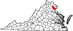 | |
| CDPs | ||
| Unincorporated communities | ||
| Footnotes | ‡This populated place also has portions in an adjacent county or counties | |
Coordinates: 38°31′19″N 77°17′23″W / 38.521871°N 77.289757°W