Quaker Ridge (NYW&B station)
| Quaker Ridge | |
|---|---|
 | |
| Location | 556 Stratton Road, New Rochelle, New York |
| Coordinates | 40°58′20.55″N 73°46′36.11″W / 40.9723750°N 73.7766972°WCoordinates: 40°58′20.55″N 73°46′36.11″W / 40.9723750°N 73.7766972°W |
| Built | 1912 |
| Architect | Stern & Fellheimer |
Quaker Ridge is a former railroad station on the White Plains branch of the New York, Westchester and Boston Railway in the city of New Rochelle in Westchester County, New York. The station is named for the Quaker Ridge section of northern New Rochelle along the Scarsdale Town border.[1] It was constructed by the New York, Westchester & Boston commuter railroad which linked Manhattan with the less populous northern Bronx section of New York City and the primarily undeveloped countryside of Westchester County.
The station was State-determined eligible for the National Register of Historic Places but as of March 2015 is not listed there.[2]
Development
The Quaker Ridge property was seen as exceptionally well located for residential purposes. It was high, perfect in drainage, rolling in topography, and afforded magnificent views of Long Island Sound. Initially fifty acres of this property was surveyed and placed on the market. The property fronted on the Quaker Ridge Station, and intersected with wide, newly built drives and boulevards.[3] The Quaker Ridge Improvement Company was later organized for further development of the surrounding area.
Station

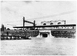
Since the NYW&B was constructed all at once, one architectural firm, Fellheimer & Long with Allen H. Stem Associated Architects,[4] designed all the stations, platforms and signals for the line. For reasons of continuity, maintenance and appearance, concrete was used as the material for all stations. Built in Renaissance, mission or classic styles, the NYW&B stations are considered among the most well-designed depots in the country.[5] The design of the Quaker Ridge station’s peaked roof was inspired by Manhattan’s Pennsylvania Station. The main structure and covered platforms are of concrete and steel, with tile covering the roof area. The station proper is 52 feet in length, while the platforms represent a covered area of 340 feet, 170 feet on each side.
From an architectural standpoint, the layout of the station was very well-designed. One unusual feature was the below-grade entrance leading to the station house located on an island platform between the northbound and southbound tracks. Commuters on the line were able to enter and leave the building with no issue and the station house protected them from the elements when necessary. The proximity to New York was a strong point of the station and the area, with commuters able to reach the southernmost point of Manhattan within fifty-three minutes or less.[6]
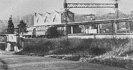
The station was built in 1912 and remained in operation until 1938 when financial distress caused the New York, Westchester & Boston Railway to shut down. The property lay dormant for many years until it was purchased by a local artist in the mid-1950s for conversion to a private residence. The building still retains most of the original details including the two original passenger platforms.[7] The original driveway and turn around for the station has been converted to a dead-end street.
References
- ↑ The United States Board on Geographic Names (GNIS) - Quaker Ridge
- ↑ Historically Significant Sites of New Rochelle
- ↑ ^ Davis, Barbara (2009). Images of America - New Rochelle. Chicago, IL: Arcadia Publishing. pp. 115.
- ↑ Potter, Janet Greenstein (1996). Alfred T. Fellheimer. New York: John Wiley & Sons, Inc. p. 174. ISBN 978-0471143895.
- ↑ Bang, Robert A. (1987). Westchester County's Million-Dollar-a-Mile Railroad. R.A. Bang.
- ↑ Arcara, Roger (1962). Westchester's Forgotten Railway, An account of the New York, Westchester and Boston Railway Company
- ↑ "Railroad Station becomes a Home” - The Deseret News
External links
| Wikimedia Commons has media related to Quaker Ridge Station. |
- NYHometownLocator - Quaker Ridge Station (historical)
- Existing Railroad Stations in Westchester County, New York
- The United States Board on Geographic Names
- New York, Westchester, & Boston Railway
- As of this edit, this article uses content from "Quaker Ridge Station (former NYW&B Railroad line) (New Rochelle, New York)", which is licensed in a way that permits reuse under the Creative Commons Attribution-ShareAlike 3.0 Unported License, but not under the GFDL. All relevant terms must be followed.
