Quadrangular castle
A quadrangular castle or courtyard castle is a type of castle characterised by ranges of buildings which are integral with the curtain walls, enclosing a central ward or quadrangle, and typically with angle towers. There is no keep and frequently no distinct gatehouse. The quadrangular form predominantly dates from the mid to late fourteenth century and signals the transition from defensively to domestically oriented great houses. The four walls are also known as ranges.
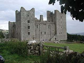
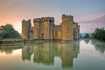
Quadrangular castles typically display a sophisticated and complex approach to the planning of internal social spaces.[1][2] There are many quadrangular castles around Britain, for example: Bodiam Castle in East Sussex, and Bolton Castle.
The 27 quadrangular castles identified by John Rickard as being built in England consist roughly 10% of the castles built in the country between 1272 and 1422. No castles of this design were built in Wales.[3]
One of the earliest quadrangular castles in Germany is Neuleiningen, of which substantial ruins remain.
List of quadrangular castles
This list is generated from data in Wikidata and is periodically updated by a bot.
Edits made within the list area will be removed on the next update!
County Durham
| Article | Place | inception | coordinate location | image |
|---|---|---|---|---|
| Lumley Castle | County Durham | 1389 | 54°51′17″N 1°33′11″W / 54.8547°N 1.55293°W |  |
| Raby Castle | County Durham | 1378 | 54°35′27″N 1°48′07″W / 54.590833333333°N 1.8019444444444°W |  |
North Yorkshire
| Article | Place | inception | coordinate location | image |
|---|---|---|---|---|
| Danby Castle | North Yorkshire | 1400 | 54°27′20″N 0°53′43″W / 54.4555°N 0.895197°W |  |
| Sheriff Hutton Castle | North Yorkshire Ryedale |
1382 | 54°05′17″N 1°00′19″W / 54.0881°N 1.00519°W |  |
Northumberland
| Article | Place | inception | coordinate location | image |
|---|---|---|---|---|
| Chillingham Castle | Northumberland | 1344 | 55°31′34″N 1°54′18″W / 55.526°N 1.905°W |  |
| Ford Castle | Northumberland | 1338 | 55°37′53″N 2°05′25″W / 55.6314°N 2.09025°W |  |
South Oxfordshire
| Article | Place | inception | coordinate location | image |
|---|---|---|---|---|
| Greys Court | South Oxfordshire | 1348 | 51°32′42″N 0°57′22″W / 51.545°N 0.956164°W |  |
| Shirburn Castle | South Oxfordshire | 1338 | 51°39′27″N 0°59′38″W / 51.6576°N 0.9938°W |  |
West Dorset
| Article | Place | inception | coordinate location | image |
|---|---|---|---|---|
| Chideock Castle | West Dorset | 1375s | 50°44′03″N 2°49′06″W / 50.7343°N 2.81825°W | |
| Woodsford Castle | West Dorset | 1336 | 50°42′45″N 2°20′38″W / 50.7126°N 2.34389°W | 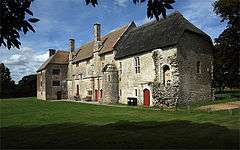 |
Misc


References
- ↑ Faulkner, P (1958). "Domestic planning from the 12th to the 14th centuries". Archaeological Journal. 115: 150–83.
- ↑ Faulkner, P (1963). "Castle planning in the fourteenth century". Archaeological Journal. 120: 215–35.
- ↑ Rickard, John (2002). The castle community: the personnel of English and Welsh castles : 1272 - 1422 (1. publ. ed.). Woodbridge: Boydell. p. 21. ISBN 9780851159133.