Qatana District
- For the Palestinian town near Jerusalem, see Qatanna.
| Qatana District منطقة قطنا | |
|---|---|
| District | |
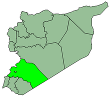
 Map of Qatana District within Rif Dimashq Governorate | |
| Coordinates (Qatana): 33°26′N 36°05′E / 33.43°N 36.08°ECoordinates: 33°26′N 36°05′E / 33.43°N 36.08°E | |
| Country |
|
| Governorate | Rif Dimashq |
| Seat | Qatana |
| Subdistricts | 3 nawāḥī |
| Area | |
| • Total | 995.48 km2 (384.36 sq mi) |
| Population (2004)[1] | |
| • Total | 207,245 |
| • Density | 210/km2 (540/sq mi) |
| Geocode | SY0308 |
Qatana District (Arabic: منطقة قطنا, translit. manṭiqat Qatana) is a district of the Rif Dimashq Governorate in southern Syria.
The district is located just to the east of Mount Hermon. Administrative centre is the city of Qatana. At the 2004 census, the district had a population of 207,245.[1]
Sub-districts
The district of Qatana is divided into three sub-districts or nawāḥī (population as of 2004[1]):
| Code | Name | Area | Population |
|---|---|---|---|
| SY030800 | Qatana nahiyah | 506.56 km² | 146,344 |
| SY030801 | Beit Jen nahiyah | 159.84 km² | 15,668 |
| SY030802 | Sa'sa' nahiyah | 329.08 km² | 45,233 |
Localities in Qatana District
According to the Central Bureau of Statistics (CBS), the following villages, towns and cities make up the district of Qatana:[1]
| English Name | Arabic Name | Population | Subdistrict |
|---|---|---|---|
| Jdeidat Artouz | جديدة عرطوز | 45,000 | Qatana |
| Qatana | قطنا | 33,996 | Qatana |
| Artouz | عرطوز | 16,199 | Qatana |
| Kanaker | كناكر | 13,950 | Sa'sa' |
| Khan al-Shih | خان الشيح | 12,148 | Qatana |
| al-Sabboura | الصبورة | 10,969 | Qatana |
| Sa'sa' | سعسع | 9,945 | Sa'sa' |
| Drousha | دروشه | 6,091 | Qatana |
| Mazraat Beit Jen | مزرعة بيت جن | 5,073 | Beit Jen |
| Yaafour | يعفور | 4,638 | Qatana |
| Beitima | بيتيما | 3,366 | Sa'sa' |
| Qalaat al-Jandal | قلعة الجندل | 3,251 | Qatana |
| Deir Maker | دير ماكر | 3,228 | Sa'sa' |
| Arnah | عرنة | 3,146 | Qatana |
| Beit Saber | بيت سابر | 3,021 | Sa'sa' |
| Kafr Hawr | كفر حور | 2,957 | Sa'sa' |
| Beit Jen | بيت جن | 2,846 | Beit Jen |
| Harfa | حرفا | 2,362 | Beit Jen |
| Beqaasem | بقعسم | 2,268 | Qatana |
| Manshiyat Khan al-Shih | منشية خان الشيح | 2,146 | Qatana |
| Darbal | دربل | 2,049 | Beit Jen |
| Hinah | حينة | 1,524 | Beit Jen |
| al-Nufour | النفور | 1,203 | Sa'sa' |
| Kawkab | كوكب | 1,188 | Qatana |
| Rima | ريمه | 1,132 | Qatana |
| al-Bejaa | البجاع | 1,058 | Qatana |
| Kafr Qouq | كفرقوق | 1,015 | Qatana |
| Denaji | دناجي | 933 | Sa'sa' |
| Ras al-Ayn | رأس العين | 892 | Qatana |
| al-Shawkatliyah | الشوكتلية | 775 | Sa'sa' |
| Dourin | دورين | 750 | Sa'sa' |
| Hamrit | حمريت | 737 | Sa'sa' |
| Maas | ماعص | 719 | Sa'sa' |
| al-Hubariyah | الهباريـة | 711 | Sa'sa' |
| Jisr al-Safra | جسر الصفراء | 704 | Sa'sa' |
| Ain al-Shaara | عين الشعره | 659 | Beit Jen |
| Abou Qawouq | أبو قاووق | 645 | Sa'sa' |
| Maghar al-Mir | مغرالمير | 588 | Beit Jen |
| al-Qleiaah | القليعة | 533 | Sa'sa' |
| Rasem al-Tahin | رسم الطحين | 455 | Sa'sa' |
| al-Maqrousa | المقروصه | 443 | Beit Jen |
| al-Aamrat | العمرات | 427 | Qatana |
| Ambiya | أمبيا | 412 | Qatana |
| Rakhlah | رخلة | 368 | Qatana |
| Hosh al-Nufour | حوش النفور | 363 | Sa'sa' |
| al-Adnaniyah | العدنانية | 238 | Sa'sa' |
| Kherbet al-Sawda | خربة السودا | 124 | Beit Jen |
References
- 1 2 3 4 "2004 Census Data" (PDF) (in Arabic). Syrian Central Bureau of Statistics. Retrieved 15 October 2015.
Also available in English: "2004 Census Data". UN OCHA. Retrieved 15 October 2015.
This article is issued from Wikipedia - version of the 10/21/2015. The text is available under the Creative Commons Attribution/Share Alike but additional terms may apply for the media files.