Qasr-e Shirin
| Qasr-e Shirin قصرشيرين | |
|---|---|
| city | |
 Qasr-e Shirin | |
| Coordinates: 34°30′56″N 45°34′45″E / 34.51556°N 45.57917°ECoordinates: 34°30′56″N 45°34′45″E / 34.51556°N 45.57917°E | |
| Country |
|
| Province | Kermanshah |
| County | Qasr-e Shirin |
| Bakhsh | Central |
| Established date | 7th century |
| Government | |
| • Mayor | Ebrahim Nazari |
| Elevation | 333 m (1,093 ft) |
| Population (2006) | |
| • Total | 15,437 |
| • Demonym | Qasri |
| Time zone | IRST (UTC+3:30) |
| • Summer (DST) | IRDT (UTC+4:30) |
| Postal code | 67817 |
| Area code(s) | 0835 |
Qasr-e Shirin (Kurdish: Qesirî Şîrîn, Persian: قصرشيرين; also Romanized as Qaşr-e Shīrīn and Qasr-ī-Shīrīn; also known as Ghasr-ī-shīrīn and Ghasr-shīrīn)[1] is a city in and the capital of Qasr-e Shirin County, Kermanshah Province, Iran. At the 2006 census, its population was 15,437, in 3,893 families.[2]
Name
The name of the city literally means Castle of Shirin in Persian. Shirin (meaning beauty/sweet) is the name of the wife of Khosrau II, king of the Sasanian Empire.
History
The city was a metropolitan during Sassanid dynastic era (226-651 AD). Ghasr-e Shírín a city with over 2000 years of history was famous for being the city of love. Khosrow II (590 to 628 AD) the twenty-second king of Sassanid dynasty built a castle for his lifelong beloved Shirin in the city. The folklore has it that Shirin was the daughter of the Queen of Armenia who fell in love with the Sassanid King. Shirin followed her love Khosrow and settled in Ghasr-e Shirin, before sending a messenger to the King in Ctesiphon informing him of her move. The king decided to build a palace for his beloved Shirin. The story of this love has become the most famous classics in Kurdish and Persian literature, and the great Persian poet Nizami has created his epic tragedies Kosrow-vo-Shirin (Khosrow and Shirin) and Shirin-o-Farhad (Shirin and Farhad), based on the two different versions of love, one characterized by happiness, glory and power, and the other by sadness, struggle, and purity. The rivalry between the powerful king who was victorious in his wars with the Byzantine empire and Farhad a master stone carver, who carved the palace of Shirin on the hard rocks of Mount Bistun and fell in love with the queen provides a pretext for Nizami to explore various psychological, spiritual, and philosophical aspects of the human tragedy.
The ruins of the castle were further damaged as a result of the Iran-Iraq war (1980–1988) that turned the area into an active battlefield. The city was occupied during eight years of war between the two countries. When Iraqi Army withdrew from the city they made sure that not a single wall stood before they left the town.
In June 2006, archaeological excavations in Shirin’s castle resulted in the discovery of the dais of the castle which was used as the seat of the king.
The city is located near the international border between Iran and Iraq, Khosravi border terminal. The famed Silk Road passes through Ghasr-e Shirin, connecting the highlands of the Iranian Plateau through a natural opening in the Zagros mountain chain with the lowland Mesopotamia and whence, the Levant and the Mediterranean basin. Being at the foothills of Zagros has made the city an important trade connection. For centuries the town has hosted the caravans of Silks and goods from far east to Arabia and Byzantium and up until 1980, when the Iran - Iraq war devastated the area, Qasr-e Shirin had a large secondhand clothes market where items, ranging from American plaid jackets to Russian leather military motorcycle coats, could be obtained. The Jews were first forced to migrate to East through Ghasr-e Shirin during ruling of Assyrian Empire in 800 BC.
Alexander the Great made his way through the same road to invade Persia in 331 BC. The waves of Arab Muslim armies advanced into the Iranian Plateau after the Battle of Jalula via Ghasr-e Shirin. The destructive invaders, the Mongols, passed through the city in 1258 on their way to destroy Baghdad and the Islamic Abbasid Caliphate. Ghasr-e Shirin has been the center of the house of the Kurdish tribe of Bajalan. The city served as the host to the Ottoman and Iranian delegates in 1639, signing the Treaty of Zohab (rather, the Armistice of Zohab) that ended the 120 Years' War between the two waring Islamic empires. The treaty fixed the border between the Ottoman and Persian empires which more or less lasts to the present day. The Treaty of Zohab left Ghasr-e Shirin in Persia/Iran but allocated the neighboring town of Khanaqin to the Ottomans, and thence Iraq.
Demographics
The majority of inhabitants are speakers of the Kurdish dialects of Kalhurri, Gurani, Pehli and of Pahlawani. A minority speaks Persian . The religions practiced by a majority of the inhabitants are shia Islam and Yarisan/Ahl-i Haqq. The small but ancient Kurdish Jews are now totally gone, as have the Baha'is, who were once numerous.
Climate
The city is well known for its agricultural productivity due to rich soil and plentiful water from the Hulwan (Alwand) River which runs through the city. The weather is mild in winter but hot and dry during the summer.
Monuments
The site houses a collection of monuments located northeast of the town today. This site contains Sassanid and early Islamic period architectural elements such as the palace assigned to Khosrau II, the remains of a stone tower known as the Ban Qal'eh and the remains of a Caravanserai of the Safavid period. The site is placed on the tentative list of UNESCO since 22/05/1997.
Recent excavations
The site of Qasr-e shirin was searched for the first time in 1891 and again in 1910. Excavations in 2006 led to the discovery of a wall of forty miles long, built by Khosro Parviz to protect the city. This wall extends beyond the border with Iraq. A canal dug at the time of the Sassanids, ends in Iraq. The water of the river Hulwan (Alwand) entered the channel by a trench and then led the water to Iraq. This canal covered with stucco stone is considered one of the masterpieces of civil engineering in irrigation.
Economy
Qasr-e Shirin has for long played an important economical role in the region. A large share of the country's exports is done via Qasr-e Shirin with its two main border points Khosravi and Parwiz border point.
Qasr-e Shirin has many modern and chic restaurants, with four three-star hotels and many other two-star hotels, serving both pilgrims to Iraq's holy Shia shrines and tourists and businessmen visiting the city. In fact, it is the city of hotels and restaurants.
There are three main shopping centers in Qasr-e Shirin, of which Artmita shopping center is the biggest and most modern. The other two are Kavian shopping center and the traditional Shah Abbasi Bazarche, the latter is the busiest one attracting people from neighboring cities and from all over the country.
Energy
See Naft shahr district
Education
Islamic Azad University of Qasr-e shirin began enrolling students in 2006. Before the establishment of this private university, Razi state university of higher education of Qasr-e Shirin which majored in agriculture had been accepting students till its closure in 2004. There is also a Payame Noor University.
Transportation
Qasr e shirin is located on one of the most important routes in Iran. Road 48 (Iran) passes through Qasr e shirin and ends in Khosravi, which is part of Karbala Freeway.
Every year hundreds of thousands of tourists go to visit Iraqi Kurdistan through Parwiz border point border terminal located north of the city.
Most of the residents travel by car through the system of roads and highways. There are many private travel agencies called phone-taxi providing inner city and inter city services to travelers.
The city is near a proposed railway route called Rahahan e gharb (Iran west railway) planned to connect Iran to Iraqi railway system and ultimately to the Syrian Mediterranean port city of Latakia. Its construction is due to be completed by 1392 Iranian year through Kermanshah-Khosravi line.
There has also been plans of building a regional airport in the vicinity.
Notable people
See Kermanshahis
See also
- Khosrau II
- Sassanid Empire
- Shirin-o-Farhad
- Love
- Taq-i Kisra
- Roman Empire
- Muslim conquest of Persia
- Treaty of Zuhab
- Holiest sites in Islam (Shia)
- Karbala
- Kalhori
- Iraqi Kurdistan
- Sulaymaniyah
- Baghdad
References
- ↑ Qasr-e Shirin can be found at GEOnet Names Server, at this link, by opening the Advanced Search box, entering "-3079964" in the "Unique Feature Id" form, and clicking on "Search Database".
- ↑ "Census of the Islamic Republic of Iran, 1385 (2006)". Islamic Republic of Iran. Archived from the original (Excel) on 2011-11-11.
External links
| Capital | 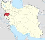 | ||||||||||||||||||||||||||||||||||||||||||||||||||||||
|---|---|---|---|---|---|---|---|---|---|---|---|---|---|---|---|---|---|---|---|---|---|---|---|---|---|---|---|---|---|---|---|---|---|---|---|---|---|---|---|---|---|---|---|---|---|---|---|---|---|---|---|---|---|---|---|
| Counties and cities | |||||||||||||||||||||||||||||||||||||||||||||||||||||||
| Sights |
| ||||||||||||||||||||||||||||||||||||||||||||||||||||||
| populated places | |||||||||||||||||||||||||||||||||||||||||||||||||||||||
| Capital | |||||||||||||||||||||||||||||||
|---|---|---|---|---|---|---|---|---|---|---|---|---|---|---|---|---|---|---|---|---|---|---|---|---|---|---|---|---|---|---|---|
| Districts |
| ||||||||||||||||||||||||||||||