Qana
| Qana قانا | |
|---|---|
| Village | |
 Qana | |
| Coordinates: 33°12′33″N 35°17′57″E / 33.20917°N 35.29917°E | |
| Grid position | 178/290 PAL |
| Country |
|
| Governorate | South Governorate |
| District | Tyre |
| Population Estimate | |
| • Total | 10,000 |
Qana, also spelled Cana, (Arabic: قانا)[1] is a village in southern Lebanon located 10 kilometres (6.2 mi) southeast of the city of Tyre and 12 kilometres (7.5 mi) north of the border with Israel. The 10,000 residents of Qana are primarily Shia[2] although there is also a Maronite Christian community in the village.
Biblical controversy
In the Gospel of John, Jesus is said to have performed his first miracle of turning water into wine at Cana in Galilee. Some Christians, especially Lebanese Christians, believe Qana to have been the actual location of this event.[2] Eusebius of the 4th century share this view in his Onomasticon.[3][4][5] However, traditions dating back to the 8th century identify Cana with the modern village of Kafr Kanna, about 7 kilometres (4.3 mi) northeast of Nazareth, Israel,[6] or nearby Khirbet Kana, and are supported by the majority of scholars.
In 1994, Nabih Berri, Lebanon's Parliament Speaker and leader of the secular Shia Amal Movement, wanted to establish a Christian shrine at a cave in Qana to attract tourists and pilgrims.[2] The government sent a 100-man company of troops to Qana to prevent potential religious conflict. This proposal was revived in 1999.[7]
History
There are many ancient ruins around the village.[8]
In 1596, it was named as a village, Qana, in the Ottoman nahiya (subdistrict) of Tibnin under the liwa' (district) of Safad, with a population of 47 households and 5 bachelors, all Muslim. The villagers paid a taxes on agricultural products, such as goats and beehives, in addition to "occasional revenues", a press for olive oil or grape syrup, and a fixed sum; a total of 3,916 akçe.[9][10]
In 1875 Victor Guérin visited: "This great village, the population of which is at least a thousand, is divided into three quartiers. The highest, called Kana el Foka, occupies the summit of the hill. It is considered the most ancient of the three. It is now entirely abandoned, except by about thirty Metawileh, and the stones of its overthrown houses are continually being removed to build new houses in the two other quarters. In the second quarter are about 600 Metawileh in the third, 400 United Greeks.'[11]
In 1881, the Palestine Exploration Fund's Survey of Western Palestine (SWP) described it: "A large village of well-built houses, whose inhabitants are partly Christians, partly Moslems. There are about 400 Christians to 500 Moslems. The ground is cultivated, and planted with olives and figs. The village is divided into two parts, with a birket between. There is a Christian church. It is situated on high ground, and is well supplied with water from the two springs, 'Ain el Gharbiyeh and 'Ain el Kussis.[12]
Modern era
Qana is known internationally for two separate incidents in which the Israeli Defense Forces caused civilian deaths during military operations in Lebanon.
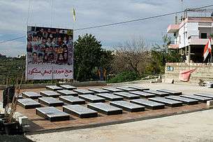
- 1996 shelling of Qana: On 18 April 1996, amid heavy fighting between the Israel Defense Forces and Hezbollah fighters during Operation Grapes of Wrath, a Fijian UNIFIL compound in the village was shelled by Israeli artillery, killing 106 civilians and injuring around 116 others who had taken refuge there to escape the fighting. Four UNIFIL soldiers were also seriously injured.[13][14]
- 2006 Qana airstrike: On 30 July 2006, during the 2006 Israel-Lebanon conflict, Israeli airstrikes hit an apartment building. The Lebanese Red Cross originally stated that at least 56 people were killed, 32 of whom were children. Human Rights Watch later announced that at least 22 people escaped the basement, and 28 are confirmed dead, of which 16 were children, with 13 more still missing.[15]
After both attacks the residents of Qana built memorials to commemorate the deaths.
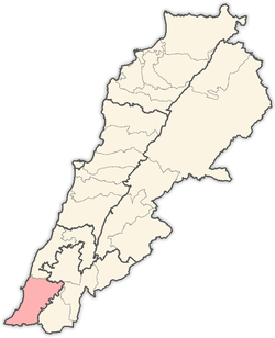
Location
Qana is located in the Tyre District within the Governorate (Mohafaza) of South Lebanon. It is 14 km (9 mi) away from the center of the caza and 92 km (57 mi) from the capital of Lebanon, Beirut. Qana stands at an altitude of 300 m (984 ft) and the town’s size is approximately 1,100 hectares (2,718 acres). Surrounding villages include Hanaway, Deir Kanoun, Rmadiyyeh, Deir Amess and Siddikine.
Residents
The registered population is an estimated 7,700 (based on the number of voters in the year 2000 that reached around 4,940). The resident population does not exceed 3,800 and the number of households is estimated at 620. In terms of confession, Shiites consistite 95% of Qana’s resident population, but the registered population is distributed as follows:[16]
- Shiite: 83%
- Maronite Catholics: 14%
- Other Christians: 3%
One can count approximately 100 families in Qana, with the largest, based on the number of voters, being the following: Attieh (580 voters), Borji (200 voters), Chalhoub (196 voters), Abdel Rida (186 voters), Sa’egh (184 voters), Jaber (158 voters), Zaarour (134 voters), Hammoud (130 voters), Dakhlallah (124 voters), Haidar (116 voters), Adib (104 voters), Salami (103 voters), Ftouni (78 voters), Madi (71 voters), Hodroj (69 voters), Haddad (152 voters), Boutros (77 voters), Shami (72 voters), Hajj (66 voters), and Abdelhussein (21 voters).
Local Authorities
The local administration in Qana is headed by a Municipal Council composed of 15 members and headed by Dr. Salah Salami. In addition, the town has four mayors: Afif Haddad, Ali Ismail, Ali Attieh and Kamel Ftouni.
Educational Sector
There are two public schools in Qana (Qana Public High School with around 600 students and the Public Intermediate School of Qana that has approximately 550 students), and two private schools (Jabal Amel Typical school which is subsidized and numbers 370 students and Jabal Amel High School with 142 students).
Service and Trade Institutions
The number of service and trade institutions in the town are estimated to be in the region of 263, dealing mainly in the fabric trade and clothing (26), food products (51), restaurants (7), barber shops (9), household items (14), bakeries and butcheries (12), pharmacies (4), smithery and mechanics (19), sawmills and galleries (13), gas stations (4), smithery and aluminum (11), libraries (4).
Agricultural Sector
The municipality of Qana owns approximately 23% of the town’s total area. Agricultural land constitutes 37% of the terrain and land ownership is distributed among approximately 220 families i.e. the town’s real estate is owned by 22% of the families in the town.
Olive cultivation consumes around 65% of agricultural land, with 15% for grains and 20% for tobacco. In addition, 62 people are employed in the agriculture sector, which is approximately 7% of the labor force.
Clubs and Associations
There are seven associations in the village of Qana distributed as follows: Qana sports club, Qana’s agricultural cooperative, Association of Qana El Jalil, El Jalil club (non-active), as well as the family associations of the Attieh, Hammoud and Zaarour families.
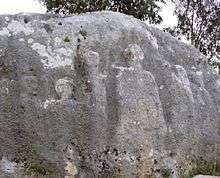
Ruins of Qana
There are natural, rock-dug caves to be found in Qana that carry old inscriptions. It is said that Jesus Christ’s first miracle took place at a wedding ceremony in one of these caves. Moreover, the tomb of King Hiram of Tyre can be found at the outskirts of the town and in the neighboring village of Hanaway.
There are also two mosques in Qana, as well as the Saint Joseph Church for Catholics.
Characteristics of Qana
Qana can be characterized by the high emigration rates it has seen, dating back to the 1920s. Increasing progressively, the current number of those who have emigrated has reached 2,500 people, which is equivalent to 32% of the registered population.
Main destinations for Qana residents include the Côte d'Ivoire (46%), Senegal (15%), Saudi Arabia (6%), the United States (6%), Zaïre (5%) as well as other countries (Sierra Leone, Kuwait, Liberia, Nigeria, France and the U.K.).
Finally, Qana’s name has become synonymous with the deaths of 100 of its residents under the Israeli ‘Grapes of Wrath’ bombardment in April 1996.
References
- ↑ From a personal name, according to Palmer 1881, p. 5
- 1 2 3 Fisk, Robert (7 January 1994). "Imam finds miracle hard to swallow: A battle is looming in the village". The Independent.
- ↑ Ewing, W (1915). "Cana". In James Orr (ed.). International Standard Bible Encyclopedia. Retrieved 2014-04-28.
- ↑ Eusebius, of Caesarea (2006) [manuscript, 1971]. "Kappa, in Joshua". In Wolf, Carl Umhau. THE ONOMASTICON OF EUSEBIUS PAMPHILI, COMPARED WITH THE VERSION OF JEROME AND ANNOTATED. tertullian.org. Retrieved 7 May 2014.
- ↑ Eusebius, of Caesarea (1904). Klostermann, Erich, ed. Das Onomastikon der Biblischen Ortsnamen. Die griechischen christlichen Schriftsteller der ersten drei Jahrhunderte (in Greek and Latin). Leipzig: J. C. Hinrichs. pp. 116–117. OCLC 490976390. Retrieved 2014-05-06.
- ↑ Ward, B (1908). "Cana". Catholic Encyclopedia. 3. New York: Robert Appleton Company.
- ↑ "Lebanon to develop Qana into Christian tourist site", Agence France-Presse, December 7, 1999.
- ↑ Conder and Kitchener, 1881, SWP I, p. 64
- ↑ Hütteroth and Abdulfattah, 1977, p. 180
- ↑ Note that Rhode, 1979, p. 6 writes that the register that Hütteroth and Abdulfattah studied was not from 1595/6, but from 1548/9
- ↑ Guérin, 1880, pp. 390-392; as given in Conder and Kitchener, 1881, SWP I, p. 49
- ↑ Conder and Kitchener, 1881, SWP I, p. 49
- ↑ "Question of the violation of human rights in the occupied Arab territories, including Palestine: written statement submitted by the Hariri Foundation". United Nations. United Nations Commission on Human Rights. 29 January 2004. Retrieved 16 May 2012.
- ↑ "Letter Dated 7 May 1996 from the Secretary-General Addressed to the President of the Security Council". United Nations Security Council. 7 May 1996. Archived from the original on May 20, 2007. Retrieved 2007-07-05.
- ↑ Human Rights Watch puts Qana death toll at 28 Archived August 30, 2006, at the Wayback Machine., Reuters, August 3, 2006.
- ↑ موقع Localiban
Bibliography
- Conder, Claude Reignier; Kitchener, H. H. (1881). The Survey of Western Palestine: Memoirs of the Topography, Orography, Hydrography, and Archaeology. 1. London: Committee of the Palestine Exploration Fund.
- Guérin, Victor (1880). Description Géographique Historique et Archéologique de la Palestine (in French). 3: Galilee, pt. 2. Paris: L'Imprimerie Nationale.
- Hütteroth, Wolf-Dieter; Abdulfattah, Kamal (1977). Historical Geography of Palestine, Transjordan and Southern Syria in the Late 16th Century. Erlanger Geographische Arbeiten, Sonderband 5. Erlangen, Germany: Vorstand der Fränkischen Geographischen Gesellschaft. ISBN 3-920405-41-2.
- Palmer, E. H. (1881). The Survey of Western Palestine: Arabic and English Name Lists Collected During the Survey by Lieutenants Conder and Kitchener, R. E. Transliterated and Explained by E.H. Palmer. Committee of the Palestine Exploration Fund.
- Rhode, Harold (1979). Administration and Population of the Sancak of Safed in the Sixteenth Century. Columbia University.
External links
- Survey of Western Palestine, Map 1: IAA, Wikimedia commons
- Qana, Localiban
Capital: Tyre | ||
| Towns and villages |
|  |
Coordinates: 33°12′33″N 35°17′57″E / 33.20917°N 35.29917°E