Qalat, Zabul
| Qalat قلات | |
|---|---|
 Qalat Location in Afghanistan | |
| Coordinates: 32°6′22″N 66°54′25″E / 32.10611°N 66.90694°ECoordinates: 32°6′22″N 66°54′25″E / 32.10611°N 66.90694°E | |
| Country |
|
| Province | Zabul Province |
| Elevation | 5,090 ft (1,550 m) |
| Population (2015) | |
| • City | 49,158 [1] |
| • Urban | 49,158 [2] |
| Time zone | UTC+4:30 |
Qalāt (Pashto/Persian: قلات), also Qalāt-e Ghiljī or Kalāt-e Ghiljī (Pashto: قلات غلجي), is a town in southern Afghanistan and the capital of Zabul Province. It is linked by Highway 1 with Kandahar to the southwest and Ghazni to the northeast. The population of the town are ethnic Pashtun tribes.
The total population of Qalat city is 49,158 (2015).[3] The city has 4 police districts (nahias) with a total land area of 4,820 Hectares [4] and 5,462 total number of dwellings.[5]
Qalat is a Provincial Centre located in southern Afghanistan. Barren land is the dominant land use classification 59% of total land.[6] While built-up land use only accounts for 19% of total land use, within that classification there is a large proportion of institutional land (33%).[7] Qalat also has two distinct industrial areas in Districts 2 and 3.
In 2006, Zabul's first airstrip was built near Qalat.[8] Qalat became home to the U.S.-led Provincial Reconstruction Team Zabul, which began assisting in development projects and building governance throughout the province.
Other names
Qalat has been known as Qalāt-e Ghiljī, Qalāt-e Khiljī, Qalāt-e Tokhī, or simply Qalāt or Kalāt.
History
The history of the area is not well documented by western sources and is marred with periods of tribal conflict, leading the area to change hands many times over the course of many years.[9]
A political mission came through the city April 16, 1857 en route to Kandahar to broker a new treaty of friendship between the British government at Peshawar and the Amir of Kabul.[10] The party was greeted by a group sent out by the heir-apparent to welcome them and check on the party's supplies. Two companies of infantry were formed so the British could inspect the troops. Afterwards, a shura was held.
Sher Ali Khan captured the city on January 22, 1867. In the battle, he lost a son, Mahomed Ali, killed in single combat by his uncle. His uncle was subsequently killed[11]
Climate
With a mild and generally warm and temperate climate, Qalat features a hot-summer mediterranean climate (Csa) under the Köppen climate classification. The average temperature in Qalat is 13.6 °C, while the annual precipitation averages 283 mm.
July is the hottest month of the year with an average temperature of 27.5 °C. The coldest month January has an average temperature of -2.9 °C.
| Climate data for Qalat | |||||||||||||
|---|---|---|---|---|---|---|---|---|---|---|---|---|---|
| Month | Jan | Feb | Mar | Apr | May | Jun | Jul | Aug | Sep | Oct | Nov | Dec | Year |
| Average high °C (°F) | 3.5 (38.3) |
7.8 (46) |
15.5 (59.9) |
22.0 (71.6) |
27.4 (81.3) |
34.5 (94.1) |
36.4 (97.5) |
34.6 (94.3) |
30.5 (86.9) |
24.2 (75.6) |
17.5 (63.5) |
10.0 (50) |
21.99 (71.58) |
| Daily mean °C (°F) | −2.9 (26.8) |
1.3 (34.3) |
8.6 (47.5) |
14.2 (57.6) |
18.5 (65.3) |
25.0 (77) |
27.5 (81.5) |
25.4 (77.7) |
20.2 (68.4) |
14.2 (57.6) |
8.7 (47.7) |
2.4 (36.3) |
13.59 (56.48) |
| Average low °C (°F) | −9.3 (15.3) |
−5.1 (22.8) |
1.7 (35.1) |
6.5 (43.7) |
9.6 (49.3) |
15.5 (59.9) |
18.6 (65.5) |
16.2 (61.2) |
10.0 (50) |
4.3 (39.7) |
0.0 (32) |
−5.1 (22.8) |
5.24 (41.44) |
| Source: Climate-Data.org[12] | |||||||||||||
American reconstruction efforts
In an effort to bring economic development to the area, Zabul province's first air strip was built just outside the city in 2006.[13] It is a dirt runway. The first flight brought in supplies for PRT Zabul and other organizations trying to rebuild the area. Three years later, a girls school was built to attempt to improve education in the area.[14] An initial school supply and prayer mat donation was made, and regular book drops and school supply donations were made until the PRT left in 2013.[15] Clean water programs around the city improved the availability of clean water sources.[16] In 2009, efforts were completed to improve the water system at the old Qalat City Hospital to bring clean drinking water to patients there.[17]
Not all the reconstruction efforts were successful, however. In 2006, construction began on a new economic district for the city. Meant to be an area of commerce and development, ten million dollars and three years later, most of the buildings are unoccupied, unusable either due to lack of the skills to maintain the buildings or due to a lack of need for the building.[18] Zabul province's governor refused to move into the new house, citing the lack of security.
Notable sites

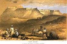
- The local skyline is dominated by a fortress constructed by the forces of Alexander the Great (see: Qalat (fortress)).[19]
- Ghar Bolan Baba, a 730m deep cave historically used for religious purposes.[20]
See also
References
- ↑ "The State of Afghan Cities Report 2015". Retrieved 22 October 2015.
- ↑ "The State of Afghan Cities Report 2015". Retrieved 22 October 2015.
- ↑ "The State of Afghan Cities Report 2015". Retrieved 22 October 2015.
- ↑ "The State of Afghan Cities Report - vol 2 2015". Retrieved 22 October 2015.
- ↑ "The State of Afghan Cities Report - vol 2 2015". Retrieved 22 October 2015.
- ↑ "The State of Afghan Cities Report - vol 2 2015". Retrieved 22 October 2015.
- ↑ "The State of Afghan Cities Report - vol 2 2015". Retrieved 22 October 2015.
- ↑ USAID/Afghanistan: First Airstrip in Zabul Province
- ↑ Noelle, Christine (1997). State and Tribe in Nineteenth-Century Afghanistan: The Reign of Amir Dost Muhammad Khan (1826-1863). New York, NY: Routledge. ISBN 0-7007-0629-1.
- ↑ Bellew, Henry Walter (1862). Journal of a Political Mission to Afghanistan in 1857, Under Major Lumsden. Smith, Elder and Co.
- ↑ Our Punjab Frontier: Being a Concise Account of the Various Tribes by which the North West Frontier of British India is Inhabited. Calcutta, India: Wyman Bros. Publishers. 1868. p. 26.
- ↑ "Climate: Qalat - Climate-Data.org". Retrieved 9 September 2016.
- ↑ "First Airstrip in Zabul Province | U.S. Agency for International Development". www.usaid.gov. Retrieved 2015-06-29.
- ↑ "Zabul PRT opens new girls' school in Qalat > U.S. Air Forces Central Command > Article Display". www.afcent.af.mil. Retrieved 2015-06-29.
- ↑ Spero, Domani. "Zabul Attack: Were They Walking in a Red Zone?". Diplopundit. Retrieved 2015-06-29.
- ↑ tSgt Jefferson, Oshawn (June 3, 2010). "Zabul Province completes projects for progress".
- ↑ Burrington, Megan. "G.I. Dough: Money as a Weapons System". Retrieved 2015-06-29.
- ↑ "The Army's $10M Afghanistan Flop". ABC News. 2009-07-30. Retrieved 2015-06-29.
- ↑ The Economist, v. 376 - 2005
- ↑ Atlas of the great caves of the world. Paul Courbon, Claude Chabert, Peter Bosted, Karen Lindsley. Cave Books, 1989. pg 21.
External links
| Wikimedia Commons has media related to Qalat, Zabul. |