Pyramid Mountain (Wells Gray-Clearwater)
| Pyramid Mountain | |
|---|---|
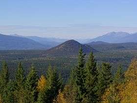 Pyramid Mountain, Sept. 2006 | |
| Highest point | |
| Elevation | 1,094 m (3,589 ft) [1] |
| Prominence | 227 m (745 ft) [1] |
| Coordinates | 51°59′40″N 120°06′16″W / 51.99444°N 120.10444°WCoordinates: 51°59′40″N 120°06′16″W / 51.99444°N 120.10444°W [2] |
| Geography | |
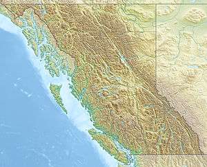 Pyramid Mountain Location in SE British Columbia | |
| Location | British Columbia, Canada |
| Topo map | NTS 92.P/16 or PS-WG3 (south half) |
| Geology | |
| Age of rock | Pleistocene |
| Mountain type | Subglacial mound |
| Volcanic arc/belt | Wells Gray-Clearwater volcanic field |
| Last eruption | 12,000 years ago |
| Climbing | |
| Easiest route | Trail off Majerus Falls trail |
Pyramid Mountain is a subglacial mound located on the Murtle Plateau in Wells Gray Provincial Park, east-central British Columbia, Canada.
Formation
Pyramid Mountain erupted about 12,000 years ago. It was once mistaken for a cinder cone and is now known to have erupted underneath about 1,600 m (5,249 ft) of glacial ice. The volcano erupted vigorously and cooled rapidly when the hot lava contacted the surrounding ice and melted it, creating an envelope of water around the rising volcano. The result was a cement-like surface with smoothed cobbles of granite, schist, phyllite and other non-volcanic pebbles which were carried by the ice from many kilometers distant. As a result of this type of eruption, Pyramid Mountain has no crater and no lava flows stretching away from its base. The secondary cone to the east (best seen from Clearwater Valley Road near Hemp Creek) was not formed by a separate eruption, but was simply a slump when the ice melted away from Pyramid, releasing the pressure against its slopes.[3][4]
Access
Pyramid Mountain can be viewed from Wells Gray Park roads at three locations:
- 1 km south of Hemp Creek on Clearwater Valley Road
- Green Mountain viewing tower (see picture above)
- Majerus Farm trailhead on Clearwater Valley Road
The trail to the top of Pyramid Mountain starts at Pyramid Campground. It is 4 km (2.5 mi) to the summit. The view is mostly southward to Trophy Mountain, Battle Mountain and Dunn Peak. The Murtle River flows along the east and south sides of Pyramid. In some weather conditions, the plume of spray over Helmcken Falls can be seen to the west.[5]
References
- 1 2 "Pyramid Mountain". Bivouac.com. Retrieved 2013-08-10.
- ↑ "Pyramid Mountain". BC Geographical Names. Retrieved 2013-08-10.
- ↑ Goward, Trevor and Hickson, Cathie (1995). Nature Wells Gray, 2nd edition. Lone Pine Publishing, Edmonton, AB. ISBN 1-55105-065-X.
- ↑ Hickson, Cathie with Hollinger, Jason (2014). Wells Gray Rocks. Thompson Rivers University, Kamloops, BC.
- ↑ Neave, Roland (2015). Exploring Wells Gray Park, 6th edition. Wells Gray Tours, Kamloops, BC. ISBN 978-0-9681932-2-8.
See also
- List of volcanoes in Canada
- Volcanism of Canada
- Volcanism of Western Canada
- Wells Gray-Clearwater volcanic field
- Pyramid Mountain (disambiguation)