Pwani Region
- For the province in Kenya known as "Pwani" in Swahili, see Coast Province.
| Pwani Region Mkoa wa Pwani (Swahili) | |
|---|---|
| Region | |
| Coast Region | |
|
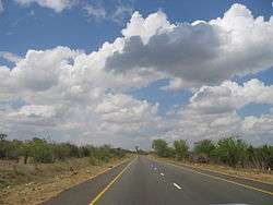
A14 trunk road connecting Dar es Salaam to the northern zone | |
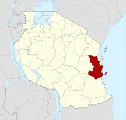 Location in Tanzania | |
| Country | Tanzania |
| Zone | Coastal |
| Capital | Kibaha |
| Government | |
| • Regional Commissioner | Mwantumu Mahiza |
| Area | |
| • Total | 32,547 km2 (12,566 sq mi) |
| Population (2012) | |
| • Total | 1,098,668 |
| • Density | 34/km2 (87/sq mi) |
| Time zone | EAT (UTC+3) |
| Postcode | 61102 |
| Area code(s) | 023 |
| Website |
pwani |
Pwani Region is one of Tanzania's 30 administrative regions. The regional capital is the town of Kibaha. According to the 2012 national census, the region had a population of 1,098,668, which was slightly lower than the pre-census projection of 1,110,917.[1]:page 2 From 2002 to 2012, the region's 2.2 percent average annual population growth rate was the seventeenth-highest in the country.[1]:page 4 It was also the 21st most densely populated region with 34 people per square kilometer.[1]:page 6 With a size of 32,407 square kilometres (12,512 sq mi),[2] the region is slightly larger than the U.S. state of Maryland (32,133 square kilometres (12,407 sq mi)).
The region is bordered to the north by the Tanga Region, to the east by the Dar es Salaam Region and the Indian Ocean, to the south by the Lindi Region, and to the west by the Morogoro Region. The word "pwani" in Kiswahili means "coast".
Districts
The region is administratively divided into six districts:
| Districts of Pwani Region | ||||||
|---|---|---|---|---|---|---|
| Map | District | Population (2012) | ||||
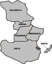 |
Bagamoyo | 311,740 | ||||
| Kibaha | 198,697 | |||||
| Kisarawe | 101,598 | |||||
| Mafia | 46,438 | |||||
| Mkuranga | 222,921 | |||||
| Rufiji | 217,274 | |||||
| Total | 1,098,668 | |||||
Education
Secondary (high) schools operated by the ministry of education in Pwani region include:
- Kibaha Secondary School (Kibaha District)
- Kibiti Secondary School (Rufiji District)
- Minaki Secondary School (Kisarawe District) — this school was established in Kisarawe in 1925, as St. Andrews College. Prior to that, it traces its history back to a Universities' Mission to Central Africa mission school established in Kiungani, Zanzibar, in 1869.[3]
References
- 1 2 3 Population Distribution by Administrative Units, United Republic of Tanzania, 2013
- ↑ Statistical Abstract 2011, Tanzania National Bureau of Statistics
- ↑ Cooper-Poole, John; Doro, Marion, eds. (1 January 2006). "Reviews: The Story of Minaki. P M Libaba Second edition 2005, with additions by Peter White". Tanzanian Affairs. 83.
Coordinates: 7°00′S 39°00′E / 7.000°S 39.000°E
| Mainland | ||
|---|---|---|
| Zanzibar | ||