Purdy Islands
The Purdy Islands (or Mwilitau Islands)[1] are an uninhabited island group in the Bismarck Sea, belonging to Papua New Guinea. The Purdy Islands, Mole, Mouse, Rat, plus Bat and Alim (or North Bat and South Bat), form part of the Admiralty Islands group, in Manus Province.[2]
History
The islands are owned by the Mbuke people.[3] They were named after hydrographer John Purdy by his friend Captain Abraham Bristow on 16 February 1817.[4] Bat Island was the site of RAAF radar station 340 RS between March 1944 and April 1944 during the Second World War.[5] It was one of five such radar stations located within the Admiralty Islands to support the American Invasion. Bat Island proved to be a very dangerous location because it was infested with rats that carried mites which in turn carried Scrub typhus. The majority of the 30 or so strong unit succumbed to Scrub typhus and the station was abandoned after just over a month of service. A contingent of survivors and reinforcements returned in May 1944 to collect the mobile LW-AW radar station and all the equipment that had been left behind. There are two survivors of this radar station still living in Australia as at November 2015.
Geography
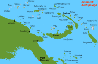
Located in the Bismarck Sea, the Purdys are part of the Admiralty Islands group, which also contains Admiralty Island, Jesus Maria Island, Los Reyes Islands, La Vandola Island, Hayrick Island, Platform Island, Small Round Island, High Island, Low Island, San Miguel Island, Elizabeth Island, Anachoretes Island, Los Monjos Island, Boudeuse Island, L'Echiquier Island, Los Eremitanos Islands, Matty Island, Durour Island, and Tiger Island. The Purdy Island group lies 38 miles (61 km) to the southwest of Manus Island and belongs administratively to Manus Province.[6][7]
The Purdy group includes five islands. These are Alim and Bat (or North Bat and South Bat),[8] as well as Mole, Mouse, and Rat.[9] Bat Island is to the west, Mouse and Mole Islands are to the east, Mole Island is to the northwest of Mouse and Mole. About 4 miles (6.4 km) west of Mouse Island can be found Latent Reef. Another reef is southwest of Bat Island. Other formations nearby include the shoals named Sherburne and Sydney, as well as the reefs named Circular and Albert.[4] They consist of coral formations.[6]
Fauna and flora
The uninhabited islands are a breeding ground for the green sea turtle.[7] The islands are visited by people only to exploit the turtle and coconut palm oil.[10]
Further reading
- Krauss, Noel Louis Hilmer (1979), Bibliography of the Purdy Islands, New Guinea
References
- ↑ Motteler, Lee S.; Bryan, Edwin Horace (January 1986). Pacific Island names: a map and name guide to the new Pacific. Bishop Museum Press. p. 51. ISBN 978-0-930897-12-3.
- ↑ Sylvia Ohnemus; Museum der Kulturen Basel (1998). An Ethnology of the Admiralty Islanders: The Alfred Bühler Collection, Museum Für Volkerkunde Basel. University of Hawaii Press. pp. 4–. ISBN 978-0-8248-2084-8.
- ↑ Anthropos. Zaunrith'sche Buch-, Kunst- und Steindruckerei. 2000. p. 25.
- 1 2 Findlay, Alexander G. (1851). A Directory for the Navigation of the Pacific Ocean (Public domain ed.). London: R.H. Laurie. p. 1034.
- ↑ url=http://radarreturns.net.au/archive/Radar%20YarnsRRWS.pdf
- 1 2 Pacific islands pilot. 1971. p. 533.
- 1 2 Groombridge, Brian (1 January 1982). The IUCN Amphibia – Reptilia Red Data Book. IUCN. p. 156. ISBN 978-2-88032-601-2.
- ↑ Pacific Islands Monthly; the Newspaper Magazine of the South Seas. Pacific Publications. 1948. p. 51.
- ↑ "Information on OC-025". RSGBIOTA.org. Islands on the Air. Retrieved 3 July 2013.
- ↑ Parkinson, Richard; White, John Peter; Dennison, John D. (2010). Thirty Years in the South Seas: Land and People, Customs and Traditions in the Bismarck Archipelago and on the German Solomon Islands. Sydney University Press. pp. 155–. ISBN 978-1-920899-63-9.
Coordinates: 2°55′2″S 146°22′0″E / 2.91722°S 146.36667°E