Puolanka
| Puolanka | ||
|---|---|---|
| Municipality | ||
| Puolangan kunta | ||
|
Puolanka Church | ||
| ||
 Location of Puolanka in Finland | ||
| Coordinates: 64°52′05″N 027°40′15″E / 64.86806°N 27.67083°ECoordinates: 64°52′05″N 027°40′15″E / 64.86806°N 27.67083°E | ||
| Country | Finland | |
| Region | Kainuu | |
| Sub-region | Kehys-Kainuu sub-region | |
| Government | ||
| • Municipal manager | Seppo Rajala | |
| Area (2011-01-01)[1] | ||
| • Total | 2,598.75 km2 (1,003.38 sq mi) | |
| • Land | 2,461.45 km2 (950.37 sq mi) | |
| • Water | 137.3 km2 (53.0 sq mi) | |
| Area rank | 28th largest in Finland | |
| Population (2016-03-31)[2] | ||
| • Total | 2,765 | |
| • Rank | 247th largest in Finland | |
| • Density | 1.12/km2 (2.9/sq mi) | |
| Population by native language[3] | ||
| • Finnish | 99.2% (official) | |
| • Others | 0.8% | |
| Population by age[4] | ||
| • 0 to 14 | 12.7% | |
| • 15 to 64 | 62.1% | |
| • 65 or older | 25.2% | |
| Time zone | EET (UTC+2) | |
| • Summer (DST) | EEST (UTC+3) | |
| Municipal tax rate[5] | 20% | |
| Website | www.puolanka.fi | |


Puolanka is a municipality in Finland located in the Kainuu region. The municipality has a population of 2,765 (31 March 2016)[2] and covers an area of 2,598.75 square kilometres (1,003.38 sq mi) of which 137.3 km2 (53.0 sq mi) is water.[1] The population density is 1.12 inhabitants per square kilometre (2.9/sq mi).
The highest waterfall in Finland, Hepoköngäs is located 16 kilometres (10 mi) from the center of Puolanka.
The municipality is unilingually Finnish. The municipality is also known as "Puolango" in Swedish documents.[6][7]
History
The first permanent settlers in Puolanka came in the 1550s.[8]
The municipality of Puolanka was established in the year of 1867. In that same year the Puolanka parish became independent from the Hyrynsalmi church to which it had previously belonged to administratively. The municipal council of Puolanka was formed in the year of 1916.[8]
At its peak Puolanka had a population of about 7,520 in 1960. Towards the end of the 1960s, however, Puolanka's population began to decline, alike other municipalities within Kainuu.[8]
Villages
Villages within Puolanka are as follows: Aittokylä, Auho, Joukokylä, Kivarinjärvi, Kotila, Kongasmäki, Leipivaara, Lylykylä, Naulaperä, Puokio, Puolanka, Rasinkylä, Suolijärvi, Vihajärvi, Väyrylä, Yli-Oterma, Törmänmäki.
Notable individuals
- Juha Sipilä, businessman and politician (attented school in Puolanka)
- Kalle Määttä, volleyball player
- Kaarina Mähönen, poet
- Kari Hiltunen, sports journalist
- Kimmo Saneri, writer
- Lasse Väisänen, footballer
- Louis Moilanen, giant
- Markku Kukkoaho, sprinter
- Santeri Haapanen, politician
- Tauno Tarkkinen, writer
- Tuulikki Pyykkönen, Olympic cross-country skier
- Unto Väisänen, baseball player
Gallery
 Lake Kalettomanlampi in Puolanka, Finland, seen from the Southernmost shore towards North-East.
 With its drop of 24 meters Hepoköngäs is the highest waterfall in Finland.
 The small lake of Ahvenlampi in Puolanka, Finland.
 The river Keskijoki in Puolanka, Finland.
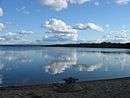 The lake of Pirttijärvi in Puolanka, Finland, seen from the beach at the North-Western end of the lake towards South-East.
 The Pohjolanjoki river in Puolanka, Finland, seen upstream from the bridge of the connecting road 8832.
 The small river of Viitajoki that runs to Kiiminkijoki at the southernmost part of the municipality of Puolanka, Finland.
 The Kuorejoki river in Puolanka, Finland.
 The lake Loukkolampi in Puolanka, Finland
 The Puolanka military cemetery
 The Puolanka military cemetery at the Puolanka church in Puolanka, Finland
 The Luppojoki river in Puolanka, Finland.
References
- 1 2 "Area by municipality as of 1 January 2011" (PDF) (in Finnish and Swedish). Land Survey of Finland. Retrieved 9 March 2011.
- 1 2 "Ennakkoväkiluku sukupuolen mukaan alueittain, maaliskuu.2016" (in Finnish). Statistics Finland. Retrieved 31 March 2016.
- ↑ "Population according to language and the number of foreigners and land area km2 by area as of 31 December 2008". Statistics Finland's PX-Web databases. Statistics Finland. Retrieved 29 March 2009.
- ↑ "Population according to age and gender by area as of 31 December 2008". Statistics Finland's PX-Web databases. Statistics Finland. Retrieved 28 April 2009.
- ↑ "List of municipal and parish tax rates in 2011". Tax Administration of Finland. 29 November 2010. Retrieved 13 March 2011.
- ↑ Kotimaisten kielten tutkimuskeskus :: Svenska ortnamn i Finland
- ↑ "Puolanka History, History of Puolanka, Puolanka City Information | Traveltill.com". Traveltill. Retrieved 2016-07-14.
- 1 2 3 "Historia". www.puolanka.fi. Retrieved 2016-07-14.
External links
![]() Media related to Puolanka at Wikimedia Commons
Media related to Puolanka at Wikimedia Commons
| Municipalities |  | |
|---|---|---|
| Former municipalities |
| |