Punakha
Punakha (Dzongkha: སྤུ་ན་ཁ་) is the administrative centre of Punakha dzongkhag, one of the 20 districts of Bhutan. Punakha was the capital of Bhutan and the seat of government until 1955, when the capital was moved to Thimphu. It is about 72 km away from Thimphu and it takes about 3 hours by car from the capital Thimphu. Unlike Thimphu it is quite warm in winter and hot in summer. It is located at an elevation of 1,200 metres above sea level and rice is grown as the main crop along the river valleys of two main rivers of Bhutan, the Pho Chu and Mo Chu. Dzongkha is widely spoken in this district.
Pungthang Dewachen Gi Phodrang

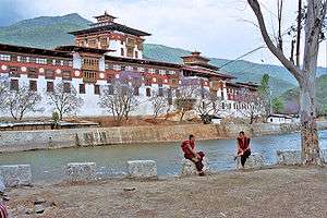
Pungthang Dewachen Phodrang (Palace of Great Happiness) or Punakha Dzong was constructed by Tuebi Zaow Balip under the great command of Zhabdrung Ngawang Namgyal in 1637 and believed to have been completed in two years of time period. It is also the country's most beautiful Dzong.It is the winter residence of Bhutan's Central Monastic Body led by HH the Je Khenpo. The Dzong houses the most sacred relics of the Southern Drukpa Kagyu school including the Rangjung Kasarpani, and the sacred remains of Zhabdrung Ngawang Namgyal and Terton Padma Lingpa.

In 1907, Punakha Dzong was the site of the coronation of Ugyen Wangchuck as the first King of Bhutan. Three years later, a treaty was signed at Punankha whereby the British agreed not to interfere in Bhutanese internal affairs and Bhutan allowed Britain to direct its foreign affairs.
In 1987, the dzong was partially destroyed by fire.
Due to its location at the confluence of the Pho Chhu and Mo Chhu rivers in the Punakha-Wangdue valley, the dzong is vulnerable to flash flooding caused by glacier lakes (GLOF). According to a recent report, flash flood damage to Punakha Dzong occurred in 1957, 1960 and 1994.[1] Currently (March 2010) work is in progress to protect the dzong from future flood damage by deepening the river channels and raising the embankments using four large steam shovels.
A covered wooden cantilever bridge crossing the Mo Chhu river was built together with the Dzong in the 17th century. This bridge was washed away by a flash flood in 1957 or 1958. In 2006 work started on a new covered wooden cantilever bridge of traditional construction with a free span of 55 meters which was completed in 2008 with the help from the Germans.[2]
Ritsha Village, Punakha
Punakha valley is famous in Bhutan for rice farming. Both red and white rice are grown along the river valley of Pho and Mo Chu, two of the most prominent rivers in Bhutan. Ritsha (meaning at the base of a hill) is a typical village in Punakha. The village houses are made of pounded mud with stone foundations. Each house is only two storeys high. Surrounding the houses are the gardens and the rice fields. The gardens also usually have fruit bearing plants like oranges and papaya among the organic vegetables. In the recent years, the farming work is mechanized and power-tillers instead of bullocks are used to plough the fields and villagers have become relatively prosperous. This is a model rice growing village in western Bhutan.
See also
References
- ↑ Chhopel, Karma (2006-03-15). "Flash Floods and Debris Flows due to Glacial Lake Outburst Floods" (ppt). Proceedings of the International Workshop on Flash Flood Forecasting coordinated by the U.S. National Oceanic and Atmospheric Administration's National Weather Service and the World Meteorological Organization, San José, Costa Rica, March 2006. Conference web site (NOAA), Abstract (pdf). Thimphu, Bhutan: Hydro-Met Services Division, Dept. of Energy, Ministry of Trade and Industry.
- ↑ Nestroy, H. N. (2008). "Re-construction of the Cantilever Bridge crossing the Mochhu (Mo-River) connecting Punakha village and Punakha Dzong in adapted traditional Bhutanese architecture.". Pro Bhutan e.v. Retrieved 2009-01-23.
External links
- Inside information about Punakha Dzong
- Pictures of Punakha Dzong on Flickr
- Photo gallery of Punakha Dzong (Nov 2005)
- Photos of Punakha Dzong
- Shabdrung Ngawang Namgyal at the Dharma Dictionary
Coordinates: 27°37′N 89°52′E / 27.617°N 89.867°E