Puna, Hawaii
Coordinates: 19°29′37.61″N 155°00′34.88″W / 19.4937806°N 155.0096889°W
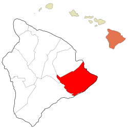
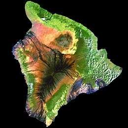
Puna is one of the 9 districts of Hawaii County on the Island of Hawaiʻi (Big Island) (County of Hawaiʻi). It is located on the windward side (east side) of the island and shares borders with South Hilo district in the north and Kaʻū district in the west.[1] With a size of just under 320,000 acres (1,300 km2), Puna is slightly smaller than the island of Kauaʻi.[1]
Housing
The affordable housing prices have led to an enormous increase in developments in Puna, and have made this district the fastest growing area on the Big Island. In the last 20 years the population has grown by nearly 20,000 people and it is estimated that Puna will have a higher population than Hilo by 2020. However, between 2002 and 2006 the price of houses more than doubled and the price of vacant land increased over fivefold, as increasing numbers of people from outside the district (often from the mainland U.S.) bought into the last affordable market in the state.
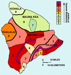
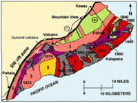
Homeowners Insurance can be more difficult to secure in the parts of Puna that are located in Lava Flow Hazard Zones 1 or 2.[2] The entire Kīlauea rift zone region is in Zone 1, while the southeastern slope is in Zone 2. Most home insurance companies will not cover homes in Zone 1 or 2 for values over $350,000. Most of the volcanic destruction of private property in Hawaiʻi since the 20th century has occurred in lower Puna, including the destruction of sections of Kapoho, Royal Gardens, Kalapana and Kaimū.[3] Approximately 50 square miles out of the 500 square miles of Puna have been covered by lava flows, and about 190 structures have been destroyed because of the flows since 1983.[4] Living in Puna has other some unique considerations. For example, most homes in Puna rely on rainwater catchment for their household water.[5][6] This lack of water availability for firefighting is also an issue with insurance companies.
Also of importance is increasing popularity of destination recreation and personal development opportunities, for example resident workshops at Kalani Oceanside Retreat.[7]:233
Climate
The climate is a mild tropical climate with abundant rainfall, especially in the northern parts and areas of higher elevation. The terrain is characterized by gentle slopes with no defined waterways. Although rainfall is occasionally very heavy (one storm in 2003 brought 36 inches (90 cm) of rain in 24 hours), flooding is rare due to the slope and porosity of the volcanic rock. The vegetation ranges from rainforest to desert shrub and coastal strand. Large areas of native forest are present in the Wao Kele o Puna and Kahauala tracts.
Recent lava activity
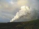
The current eruption has been going on since 1983. Recent Kilauea Status Reports, Updates, and Information Releases are published daily by the Hawaii Volcano Observatory Historic photos and details of previous flows are also available on that website.
As of October 4, 2014, the "Current Volcano Alert Level" was set at "WARNING", due to lava flowing towards the village of Pahoa.
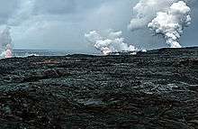
Hawaii Volcanoes National Park, when constructed, had two entrances. The entrance from lower Puna was cut off in 1986, and several miles of the road along the ocean were covered by several flows that occurred over the course of the eruption.[8] Tourists are particularly interested in observing the lava when it is flowing into the ocean and where they can get a close look. To find out where the flow is currently going and best places to park, consult the links provided.
Lava flows have continued to add new land to the old shoreline in an intermittent fashion, with lava constantly changing directions and sometimes relocating into new areas. The lava itself and the new land it creates can be hazardous, and anyone visiting the area should consult publication Volcanic Hazards on the Island of Hawai`i
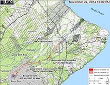
In June 2014, a lava flow dubbed the June 27th flow started flowing from a vent[9] of a spatter cone called Pu'u O'o on the east rift zone of Kilauea Volcano in a northwest direction towards the villages of Kaohe Homesteads and Pahoa.[10]
2014 Lava Flow
In early September it appeared that the lava flow was en route to the small community of Kaohe Homesteads. Community leaders and state officials began to draw up plans for evacuations and the mayor signed an emergency proclamation as residents of the Kaohe Homesteads subdivision learned that lava from Kilauea Volcano was just 0.8 of a mile away and could reach them within a week.[11] On September 13, a release from the Hawaiian Volcano Observatory stated that the flow had begun to shift away from the subdivision as it had interacted with both the cracks and down-dropped blocks within the East Rift Zone of Kīlauea volcano and a natural valley that leveled away from Kaohe Homesteads.[12]
The lava flow was now heading towards the community of Pahoa, Hawaii. On October 25, the flow had crossed Cemetery Road at Apa'a Road near the Pahoa Recycling and Transfer Station, a waste/trash station, which was closed and relocated due to the lava flow.[13] The flow was quickly advancing on a nearby cemetery and triggered the first series of evacuations.[14][15] On November 10, the flow claimed the first (but only) home.[16]
Officials feared that if the lava flow continued on its path it will cover over the only route in and out of lower Puna, Highway 130. On October 22, The National Park Service announced [17] that it would help state and county officials create an emergency route along 8 miles of the buried Chain of Craters Road in order to help Puna residents who will lose access to the rest of Hawai‘i if the current lava flow covers Highway 130. Construction of the Chain of Craters alternate route began by making a path over a wall of lava rock covering the road in Hawaii Volcanoes National Park. The $12 million to $15.5 million route, to be re-established between the park and Kalapana as a gravel road, would have been the only road in and out of lower Puna, if the June 27 lava flow had made its way to the sea. The park closed the end of Chain of Craters Road as construction began. Nearly 8 miles of the roadway, officially known as Chain of Craters Road inside the park and Highway 130 outside of it, is covered by past flows from the ongoing Pu'u O'o eruption that threatened Pahoa. Chain of Craters Road, which opened in 1965, had portions blocked or covered by lava for 37 years of its 49-year existence, according to the park. The road is about 19 miles long inside the park.[18] However the 2014 lava flow did not continue further.
Census-designated places and other areas within Puna
- ʻĀinaloa
- Black Sands
- Eden Roc
- Fern Acres
- Fern Forest
- Glenwood
- Hawaiian Acres
- Hawaiian Beaches
- Hawaiian Paradise Park
- Kalapana
- Kapoho
- Keaʻau
- Kehena
- Kurtistown
- Mountain View
- Nānāwale Estates
- Orchidland
- Pāhoa
- Volcano Village
Puna places of interest
Besides visiting the active Kīlauea volcano and the currently active lava flows in the area of Kalapana, another interesting site within the Puna district are the heated tide pools at Ahalanui Beach Park (aka Puʻalaʻa County Park), where spring water has been naturally heated through geothermal energy and this mixes with ocean water along the shoreline. Prior to the eruption in 1960 at Kapoho, the pools were not heated but were cold.
- Ahalanui Beach Park
- Akatsuka Orchid Gardens
- Hawaii Volcanoes National Park, (the entrance is actually inside the district of Kaʻū)
- Hilo Coffee Mill, Mountain View
- Issac Hale Beach Park (Pohoiki)
- J. Hara Store, Kurtistown
- Kalani Honua Retreat Center
- Keaʻau Shopping Center
- MacKenzie State Recreation Area
- Makuʻu Farmer's Market
- Mauna Loa Macadamia Nut Corporation
- Lava Tree State Monument
- Pāhoa Park
- Puna Hongwanji Mission
- Star of the Sea Painted Church
- Ulua Theatre, Volcano Village
- Volcano Skate Park
- W. H. Shipman Park
Notable people from Puna
- Jason Scott Lee, Actor, owner and creator of Ulua Theatre, Volcano Village resident [19]
- William "Billy" Kenoi, Mayor of Hawaiʻi County (2008–present)
- Harry Kim, Mayor of Hawaiʻi County (2000–2008)
- Joseph Nāwahī, Native Hawaiian legislator, newspaper publisher, and painter
- Emily Naeole, Hawaiʻi County Councilwoman [20]
- Abra Moore, Folk-styled rock singer-songwriter
- William H. Shipman, Founder of W. H. Shipman Ltd., agricultural entrepreneur, and major private land owner in Puna
- Herbert C. Shipman, Son of W. H. Shipman, known for saving nēnē through breeding at the Shipman Estate
References
- 1 2 Hawaii County Data Book
- ↑ Lava flow zone hazard maps USGS
- ↑ Hazard zones for lava flows on Kilauea USGS
- ↑ USGS Summary of the Pu`u `Ō `ō-Kupaianaha Eruption, 1983-present
- ↑ College of Tropical Agriculture and Human Resources (CTAHR) University of Hawaii at Manoa
- ↑ Free CTAHR Publications
- ↑ Yamamoto, Luci, and Gorry, Conner. 2011. Lonely Planet Discover Hawaii the Big Island (Travel Guide). Lonely Planet Publications. ISBN 978-1742204659.
- ↑ USGS website with detailed historical account of Kīlauea lava flows
- ↑ Choi, Kenny (27 June 2014). "New Video: Pu'u O'o crater develops new outlet for lava". KITV 4. kitv.com. Retrieved 27 October 2014.
- ↑ "Lava on track to reach Pahoa in two weeks". Honolulu Star Advertiser. 9 September 2014. Retrieved 27 October 2014.
- ↑ Nakaso, Dan; Moseley, Megan (4 September 2014). "Big Isle resident vows to stay until lava burns house". Honolulu Star Advertiser. Retrieved 27 October 2014.
- ↑ "Lava slows, misses first homes for now". Volcano Discovery. Retrieved 27 October 2014.
- ↑ "Pahoa Transfer Station to Close Friday". Big Island Now. 23 October 2014. Retrieved 27 October 2014.
- ↑ "Lava enters Pahoa cemetery grounds". KITV 4. kitv.com. 26 October 2014. Retrieved 26 October 2014.
- ↑ "Lava nears, evacuations loom". West Hawaii Today. Stevens Media. 26 October 2014. Retrieved 26 October 2014.
- ↑ "First house claimed by Puna lava flow". Retrieved 11 November 2014.
- ↑ Ferracane, Jessica. ""End of the Road" will close during emergency route construction". National Park Service: Hawaii Volcano National Park. NPS. Retrieved 26 October 2014.
- ↑ "Lava-clearing to begin on Ka'u side of historic road". West Hawaii Today. Stephens Media. 22 October 2014. Retrieved 26 October 2014.
- ↑ Midweek Magazine Cover Story
- ↑ Hawaiʻi County Council Biography