Pullenvale, Queensland
| Pullenvale Brisbane, Queensland | |||||||||||||
|---|---|---|---|---|---|---|---|---|---|---|---|---|---|
 Pullenvale Hall | |||||||||||||
| Population | 3,154 (2006 census)[1] | ||||||||||||
| • Density | 129.26/km2 (334.8/sq mi) | ||||||||||||
| Postcode(s) | 4069 | ||||||||||||
| Area | 24.4 km2 (9.4 sq mi) | ||||||||||||
| LGA(s) |
City of Brisbane (Pullenvale Ward) | ||||||||||||
| State electorate(s) | Moggill | ||||||||||||
| Federal Division(s) | Ryan | ||||||||||||
| |||||||||||||
Pullenvale is a suburb in the City of Brisbane, Queensland, Australia.[2] It is situated approximately 15 kilometres (9.3 mi) west of the Brisbane central business district. Located in the southern foothills of Mount Elphinstone, Pullenvale features rolling hills and areas of bush land, and is spread over an area of approximately 24.4 square kilometres (9.4 sq mi).
History
There are a number of theories about the original of the name Pullenvale. One theory from a 1920s newspaper is that it is named after early timbergetter, George Pullen; however, no land records have been found to confirm this. Given that the local creek is known as Pullen Pullen Creek, some people believe the repetition suggests a word from one of the Australian Aboriginal languages possibly meaning "to die" (or "not to die") or "fighting" (or "fighting ground"). Another theory is that the Pullen Pullen name was originally Bullen Bullen, an Aboriginal word meaning "lonely place".[2][3] In support of the "fighting" theory, there is an 1850 newspaper account:[4]
NATIVE AMUSEMENTS.-The aborigines held a grand "Pullen-Pullen" last week, near Brisbane. Many of the "Ningy-Ningy" and Limestone blacks attended. We are informed that some of them received spear wounds upon the occasion, but no deaths occurred.
There is evidence that there was a Mr Pullen who had a vineyard at Pullevale from about the 1862 to at least 1885.[5]
The name Glen Pullen predated the name Pullenvale, which is described as a "new name" in 1873.[3][6] There is an 1873 reference to Glenpullen Farm at Pullenvale.[7]
Demographics
In the 2011 census the population of Pullenvale was 3,174, 49.8% female and 50.2% male.
The median age of the Pullenvale population was 39 years, 2 years above the Australian median.
68.2% of people living in Pullenvale were born in Australia, compared to the national average of 69.8%; the next most common countries of birth were England 10.3%, South Africa 4.6%, New Zealand 2.4%, United States of America 1.4%, Scotland 1.1%.
91.2% of people spoke only English at home; the next most common languages were 1.1% Afrikaans, 0.7% German, 0.6% Japanese, 0.5% Mandarin, 0.4% Cantonese.
Landmarks
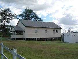
Pullenvale Hall, located at 302 Grandview Road, Pullenvale, is an old pineapple packing shed. The Hall was purchased from resident Jack Woodward in about 1943.[8] It is the centre of many small functions and classes run by the residents of Pullenvale in cooperation with the Local Council.
Sporting clubs
Moggill Pony Club Inc. was formed in 1960. The land located at, 41 O'Brien Road, Pullenvale, is owned by the Pony Club.[9] The Pony Club is one of the oldest pony clubs in Queensland and covers four hectares of land.
Development
Pioneer Pullenvale residents developed a logging industry. The construction of Moggill Road, linking Brisbane with Ipswich via Moggill, made the area more accessible. Eventually the logging industry give way to small crop and dairy farming. The resulting tiny population of farming families led to the establishment of the Pullenvale State School in 1873. For the next 100 years or so the rural population remained steady, it was not until 1981 that the State School was rebuilt to cater for a great increase in population that stemmed from the encroaching Brisbane metropolis.
References
- ↑ Australian Bureau of Statistics (25 October 2007). "Pullenvale (Statistical Local Area)". 2006 Census QuickStats. Retrieved 13 October 2007.
- 1 2 "Pullenvale (entry 43080)". Queensland Place Names. Queensland Government. Retrieved 14 February 2014.
- 1 2 "History of Pullenvale". Moggill Historical Society Inc. Retrieved 13 February 2014.
- ↑ "DOMESTIC INTELLIGENCE.". The Moreton Bay Courier. Brisbane: National Library of Australia. 2 February 1850. p. 2. Retrieved 13 February 2014.
- ↑ "Pullenvale Vineyard.". The Queenslander. Brisbane: National Library of Australia. 12 December 1885. p. 959. Retrieved 13 February 2014.
- ↑ "PULLENVALE.". The Queenslander. Brisbane: National Library of Australia. 28 June 1873. p. 3. Retrieved 13 February 2014.
- ↑ "Family Notices.". The Brisbane Courier. National Library of Australia. 8 July 1873. p. 4. Retrieved 13 February 2014.
- ↑ "Brief History of Moggill and Pullenvale". Moggill Historical Society Inc. Retrieved 13 February 2014.
- ↑ Moggill Pony Club Inc.. Retrieved 18 September 2010
External links
| Wikimedia Commons has media related to Pullenvale, Queensland. |
- University of Queensland: Queensland Places: Pullenvale
- "Pullenvale". BRISbites. Brisbane City Council. Archived from the original on 22 July 2008.
- "Pullenvale". Our Brisbane. Brisbane City Council. Archived from the original on 6 March 2008.
- "Brief History of Moggill and Pullenvale". Moggill Historical Society Inc.
- Brisrain webcentral, Used in general, archived on 22 February 2014
Coordinates: 27°31′02″S 152°53′29″E / 27.5171°S 152.8914°E