Pukehou
Pukehou is a farming locality in southern Hawke's Bay, in the eastern North Island of New Zealand.
Description
Pukehou is located on State Highway 2, about half way between Hastings and Waipukurau. The locality's name (originally Pukehouhou) is Māori, and means "Hill of houhou", the 'houhou' or 'Puahou' being a small native flowering tree, Pseudopanax arboreus or Five Finger (Māori: 'Puahou' or 'Whauwhaupaku').
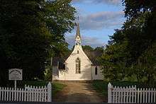
Samuel Williams, who established the nearby Te Aute College, also built Christ Church in Pukehou. The present building was constructed in 1859 and is the oldest church in the Waiapu Diocese and Hawke's Bay. The church was constructed of local timber with roofing of hand split totara shingles and measured 40 feet by 20 feet. The church was extended in both 1881 and 1893, work in the latter date including the north and south transept and chancel. The church was repaired in 1959 with the roof being repiled, repainted and reshingled. The church was most recently repainted in 1993. The church has two significant stained glass windows. The east window was designed by John Bonnor while Karl Parsons designed the north one. The church is registered as a Category I heritage building by the New Zealand Historic Places Trust.[1]
Samuel Williams was the Rural Dean of Hawke's Bay from 1854 to 1888. He was archdeacon in 1888 and in 1889 was canon of Cathedral of St John the Evangelist in Napier.[2][3][4]
Schools include Te Aute College. There is a marae at Pukehou.
References
- ↑ "Christ Church (Anglican)". Register of Historic Places. Heritage New Zealand. Retrieved 16 June 2012.
- ↑ Boyd, Mary. "Williams, Samuel - Biography". Dictionary of New Zealand Biography. Ministry for Culture and Heritage. Retrieved 13 June 2012.
- ↑ Woods, Sybil M. (1981). Samuel Williams of Te Aute. Pegasus Press.
- ↑ "Raising the Bar – Samuel Williams and Maori Education" (PDF). New Zealand Church Missionary Society. 2013. Retrieved 28 December 2013.
|first1=missing|last1=in Authors list (help)
Coordinates: 39°50′S 176°38′E / 39.833°S 176.633°E