Pukara (Sandia)
This article is about the mountain in the Sandia Province, Puno Region, Peru. For other uses, see
Pukara (disambiguation).
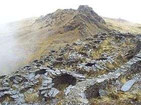
Pukara (Quechua for fortress,[3] hispanicized spelling Pucara) is a mountain in the Andes of Peru, about 4,200-metre (13,800 ft) high, with an archaeological site on top. It is located in the Puno Region, Sandia Province, Patambuco District, southwest of Patambuco. The pre-Inca funerary site is also known as Trinchera (Spanish for trench). The place was declared a National Cultural Heritage by Resolución Directoral Nacional No. 296/INC-2003 by the National Institute of Culture. It consists of tombs, walls, houses, squares and tunnels.[1][4]
References
- 1 2 escale.minedu.gob.pe - UGEL map of the Sandia Province (Puno Region)
- ↑ "Cerro Pucara". IGM, Peru. Retrieved July 25, 2015.
- ↑ Teofilo Laime Ajacopa, Diccionario Bilingüe Iskay simipi yuyayk'ancha, La Paz, 2007 (Quechua-Spanish dictionary)
- ↑ "Sitio arqueológico de Trinchera". mincetur. Retrieved July 25, 2015.
|
|---|
|
- Acaray
- Amaru Marka Wasi
- Arhuaturo
- Asana
- Asiru Phat'jata
- Aspero
- Awila Qhincha Mach'ay
- Awkin Punta
- Awkillu Waqra
- Awkimarka (Apurímac)
- Awkimarka (Huánuco)
- Awqa Punta
- Aya Muqu
- Ayamach'ay
- Ayawayq'u
- Azángaro
- Baths of Boza
- Bandurria
- Buena Vista
- Cahuachi
- Cajamarquilla
- Cao Viejo
- Carajía
- Caral
- Caves of Sumbay
- Cerro Baúl
- Cerro Pátapo
- Cerro Trinidad
- Chakamarka
- Chan Chan
- Chankillo
- Chauchilla Cemetery
- Chavín de Huantar
- Chawaytiri
- Chichakuri
- Chipaw Marka
- Chuqik'iraw
- Chuqik'iraw Pukyu
- Chuqi Pukyu
- Churajón
- Chuya
- Ch'iqullu
- Cota Coca
- Cumbe Mayo
- El Brujo
- El Cañoncillo
- El Ingenio
- El Paraíso
- Garagay
- Gran Pajáten
- Gran Vilaya
- Guitarrero Cave
- Hatun Rumiyuq
- Hatun Mach'ay
- Hatun Misapata
- Hatun Uchku
- Hatun Usnu
- Hatunmarka
- Hunqupampa
- Inka Mach'ay
- Inka Raqay, Apurímac
- Inka Raqay, Ayacucho
- Inka Tampu, Cajamarca
- Inka Tampu, Huayopata
- Inka Tampu, Vilcabamba
- Inka Tunuwiri
- Inka Uyu
- Inka Wasi, Ayacucho
- Inka Wasi, Huancavelica
- Inka Wasi, Lima
- Inkapintay
- Inkill Tampu
- Inti Punku
- Inti Watana, Ayacucho
- Inti Watana, Calca
- Inti Watana, Urubamba
- Intikancha
- Intini Uyu Pata
- Intipa Ñawin
- Intiyuq K'uchu
- Iskuqucha
- Isuq
- Jinkiori
- Jisk'a Iru Muqu
- Kanichi
- Killa Mach'ay
- Killa Rumi
- Killarumiyuq
- Kiswar
- Kotosh
- Kuelap
- Kukuli
- Kuntur Wasi
- Kunturmarka, Ayacucho
- Kunturmarka, Pasco
- Kuntur Qaqa
- Kuntuyuq
- Kusichaka valley
- Kutimpu
- Khichuqaqa
- Khuchi Mach'ay
- K'allapayuq Urqu
- K'anamarka
- K'ipakhara
- Laguna de las Momias
- Lawriqucha
- Layzón
- Llamachayuq
- Llamachayuq Qaqa
- Llamayuq
- Llamuqa
- Llaqta Qulluy, Acoria
- Llaqta Qulluy, Conayca
- Llaqta Qulluy, Tayacaja
- Llaqta Qulluy, Vilca
- Llaqtan
- Llaqtapata
- Machu Pikchu
- Machu Pirqa
- Machu Pitumarka
- Machu Q'inti
- Machu Qullqa
- Mameria
- Maray Qalla
- Marayniyuq
- Markahirka
- Markansaya
- Markapukyu
- Markawamachuku
- Marpa
- Mawk'allaqta, Castilla
- Mawk'allaqta, Espinar
- Mawk'allaqta, La Unión
- Mawk'allaqta, Melgar
- Mawk'allaqta, Paruro
- Mawk'allaqta, Sandia
- Mawk'ataray
- Mayqu Amaya
- Mazur
- Mikulla
- Millka
- Miraflores
- Mirq'imarka
- Miyu Pampa
- Mulinuyuq
- Mullu Q'awa
- Mulluq'u
- Muray
- Muyu Muyu
- Muyu Urqu
- Muyuq Marka
- Nazca Lines
- Nina Kiru
- Ninamarka
- Ñawpallaqta, Huanca Sancos
- Ñawpallaqta, Fajardo
- Ñawpallaqta, Lucanas
- Ñust'a Hisp'ana
- Pacatnamu
- Pachakamaq
- Pachatusan
- Paiján
- Pañamarka
- Paracas Candelabra
- Paraxra
- Patallaqta
- Phiruru
- Pikillaqta
- Pikimach'ay
- Pilluchu
- Pinkuylluna
- Pirqa Pirqa, La Libertad
- Pirqa Pirqa, Lima
- Pirwalla
- Pirwayuq
- P'isaq
- Puka Pukara
- Puka Tampu
- Puka Urqu
- Pukara, Coporaque
- Pukara, Fajardo
- Pukara, Puno
- Pukara, Vilcas Huamán
- Pukarani
- Pumamarka, San Sebastián
- Pumamarka, Urubamba
- Pumaq Hirka
- Pumawasi
- Punkuri
- Puqin Kancha
- Puruchuco
- Purum Llaqta, Cheto
- Purum Llaqta, Soloco
- Pusharo
- Pusuquy Pata
- Phuyupatamarka
- Qaqapatan
- Qillqatani
- Quchapata
- Qillqa
- Qillqay Mach'ay
- Quchapampa
- Quiaca
- Qullqanpata
- Qullqapampa
- Qulu Qulu
- Qunchamarka
- Qunchupata
- Quri Winchus
- Qurikancha
- Qurimarka, Apurímac
- Qurimarka, Cusco
- Quriwayrachina, Anta
- Quriwayrachina, Ayacucho
- Quriwayrachina, La Convención
- Quyllur
- Q'arachupa
- Qasa Pata
- Qhapaq Kancha
- Q'illaywasin
- Q'inqu
- Q'inq'u
- Raimondi Stele
- Raqch'i
- Revash
- Rumiqullqa
- Rumiwasi
- Runayuq
- Runkuraqay
- Saksaywaman
- Sara Sara
- Sayaqmarka
- Sayhuite
- Sechin
- Sillustani
- Sipán
- Suntur
- Susupillu
- Tambo Totem
- Tampu Mach'ay, Cusco
- Tampu Mach'ay, Huancavelica
- Tampukancha
- Tanqa Tanqa
- Tantarica
- Taqrachullu
- Tarawasi
- Tarmatampu
- Templo del Zorro
- The Toads of Wiraqucha
- Tikra
- Tinyaq
- Tipón
- Titiqaqa
- Toquepala Caves
- Toro Muerto
- Trinchera
- Túcume
- Tunanmarka
- Tunay Q'asa
- Tupu Inka
- T'akaq
- T'uqu T'uquyuq
- Uchkus Inkañan
- Ullantaytampu
- Urpish
- Uskallaqta
- Usnu, Ayacucho
- Usnu, Huánuco
- Usnu Muqu
- Usqunta
- Uyu Uyu
- Venado cautivo
- Ventanillas de Otuzco
- Ventarron
- Vitcos
- Wak'a del Dragón
- Wak'a Wallamarka
- Wak'a de la Luna
- Wak'a del Sol
- Wak'a of San Marcos
- Wak'a of Santa Ana
- Wak'a Prieta
- Wak'a Pukllana
- Wallpayunka
- Waman Pirqa
- Wamanilla
- Wamanmarka, Chumbivilcas
- Wamanmarka, La Convención
- Wamanmarka, Lima
- Wamp'uy
- Wanakawri, Cusco
- Wanakawri, Huánuco
- Wanqaran
- Wanuku Pampa
- Waqlamarka
- Waqramarka
- Waqra Pukara
- Waqutu
- Warahirka
- Waraqayuq
- Waraqu Urqu
- Warawtampu
- Wari ruins
- Wari Willka
- Waruq
- Wat'a, Cusco
- Wat'a, Huánuco
- Wayna Pikchu
- Wayna Q'inti
- Wayna Tawqaray
- Wayra Punku
- Wichama
- Wichqana
- Wich'un
- Wila Wilani
- Willka
- Willkapampa
- Willkaraqay
- Willkawaman
- Willkawayin
- Wiñaw
- Wiñay Wayna
- Wiraqucha Pirqa
- Wiraquchapampa
- Yanaca
- Yanaqi - Qillqamarka
- Yaynu
- Yuraq Mach'ay
|