Puerto Quito
| Quito | |
|---|---|
| Town & Urban Parish | |
 | |
| Country | Ecuador |
| Province | Pichincha |
| Canton | Puerto Quito |
| Settled | 1965 |
| Established | April 1, 1996 |
| Government | |
| • Mayor | Narciza Párraga de Monar |
| Highest elevation | 160 m (520 ft) |
| Lowest elevation | 120 m (390 ft) |
| Time zone | ECT (UTC-5) |
| Postal Code | EC170950 |
| Climate | Am |
| Website | http://www.puertoquito.gov.ec/ |
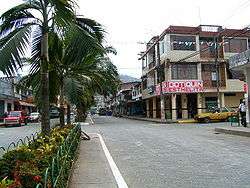
Puerto Quito is a town and urban parish in the province of Pichincha, Ecuador. The town is a developing area for eco-tourism, thanks to an abundance of wildlife, secondary jungle and beautiful waterfalls such as the Cascada Azul (Blue Waterfall). Puerto Quito is situated beside a major bridge over the river Caoní on the main road from Quito to the coast. By road, Quito is 140 km or 3.5 hours by bus.
Geography and climate
Although geographically part of the Sierra region of Ecuador, Puerto Quito's climate and geography is closer to that of the coastal region. The town is located in the tropical forest of Ecuador. As such, it has a higher temperature than the rest of the province, averaging around 25 degree celsius year-round. Average rainfall is between one and two meters a year.
External links
- Official website (Spanish)
- Tourist Information - (English and Spanish)
- Information about Puerto Quito - Government of Pichincha Province (Spanish)
Coordinates: 0°07′38″N 79°15′11″W / 0.12720°N 79.253139°W
Canton seats in Pichincha | ||
|---|---|---|