Puerto Ordaz and San Felix
| Puerto Ordaz | |
|---|---|
 | |
| Country |
|
| Founded | February 9, 1952 |
| Government | |
| • Mayor | Jose Ramon Lopez |
| Area | |
| • Total | 1,930 km2 (750 sq mi) |
| Population (2001) | |
| • Total | 600,000 |
| • Demonym | guayanés |
| Time zone | VST (UTC-4:30) |
| • Summer (DST) | not observed (UTC-4:30) |
| Area code(s) | 0286 |
| Climate | Aw |
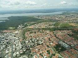
Puerto Ordaz (Spanish pronunciation: [ˈpwerto orˈðas]) is a planned city which, together with the older settlement of San Félix, forms Ciudad Guayana in Bolívar State, eastern Venezuela. Puerto Ordaz is located at the confluence of the Caroní and Orinoco Rivers[1] and is the site of the Llovizna Falls. There are bridges across the Caroni and a new bridge across the Orinoco (Second Orinoco crossing). It is one of Venezuela's largest cities and is the base for large iron and steelworks and aluminium industries. The city has a large hydroelectric power plant, Macagua Dam.
Due to its planned nature, the city has a drastically different feel to it than many other South American cities. The towers of the Alta Vista district recall New York City, and many of the residential neighborhoods have architecture and landscaping that are similar to suburbs in the United States in the 1950s, including 'cookie cutter' homes, sidewalks, and patterned lawns. This is an artifact due to the presence in the 1960s and early 1970s of US Steel, an American company with iron mining operations in the region.[2] US Steel built housing for hundreds of its American expatriate workers and families, who lived in Puerto Ordaz and other communities until the nationalization of the Venezuelan steel industry forced the company and its workers to leave.
Economic activity
Many of Venezuela's prime industries are based in Puerto Ordaz. These include Alcasa, Venalum, Bauxilum, Carbonorca (primary aluminium manufacturers and anode suppliers for the aluminium industry), Ferrominera (iron ore processing), and Ternium Sidor (Orinoco Steelmaking). The country's main electricity producer, Edelca, and the regional development office, CVG (Corporación Venezolana de Guayana), are also located in Puerto Ordaz..
Port
The port of Puerto Ordaz in a combination of piers (muelles), all under the control of CVG, of which only one is considered for public use. The others are directly related to the CVG production companies in principal all aluminium related, approximately 9 piers in total. One of the most frequently used piers is Ferrominera at the mouth of the Caroni river. Another is Ternium Sidor (recently nationalised into a CVG company, and the only steel works) at mile 197.
Hydroelectric Centrals
In Puerto Ordaz is located the Electricity industry of Caroní (Edelca) which manage several of the hydroelectric centrals over the Caroní river: Macagua I and II and Caruachi, all of the 3 located on the urban side of Ciudad Guayana. Edelca also built and administers Guri (currently the world's 4th biggest dam, in terms of the capacity of hydroelectric generation) and gave origin to the Guri reservoir, the second biggest lake in Venezuela.

Transportation
Puerto Ordaz is crisscrossed from north to south and east to west by numerous avenues. Some of them are:
- Guayana Avenue is the main traffic avenue of the city, since it crisscrosses the city from its start to its end. It begins at the toll on the "Ciudad Bolívar-Ciudad Guayana" Highway, and goes all the way through Puerto Ordaz (industrial zone, airport, commercial zone, residential zone, even the touristic zone since it side passes the Cachamay Park).
- Atlántico Avenue runs through Puerto Ordaz from west to east on the south side of the city. It intersects with the Las Americas avenue and the Leopoldo Sucre Figarella avenue. This gives a high importance to this avenue.
- Las Américas Avenue connects the Altavista sector (north of the city) with the centre.
- Paseo Caroní Avenue starts on the west side of the city and ends at the Atlantic avenue.
On December 3, 2006, the Orinokia bridge, which crosses the Orinoco river, was inaugurated.
Recreation
In Puerto Ordaz the principal recreation centers are:
- Natural: Llovizna park, Cachamay park, Loefling park.
- Shopping centers: Orinokia mall, Altavista Mall, Atlántico Mall.
- Family: Macagua Eco museum, Christmas Park and the Italian-Venezuelan Club.
Colleges
Puerto Ordaz is also well known for having one of the best engineering schools in Latin America. The main universities are:
Regional hubs:
- Andrés Bello UCAB (Catholic University)
- UDO (East University)
- Gran Mariscal de Ayacucho (UGMA) University
- Bicentenaria de Aragua (UBA) University
Puerto Ordaz is headquarters of colleges like:
- UNEXPO (National Experimental Polytechnic University)
- UNEG (National Experimental University of Guayana)
Technical Institutes
- U.E.E.T.I. Fundación "La Salle" (San Félix)
- I.U.T. Antonio José de Sucre
- I.U.T. Pedro Emilio Coll
- I.U.P. Santiago Mariño
Tourism

Inside the city both the Llovizna and Cachamay Parks are located displaying their picturesque waterfalls. Other local attractions are the Caroní Ecomuseum located at the Macagua Dam. Near the city from the Angosturita bridge to the San Félix port the union of the Caroní and Orinoco rivers can be seen; the different colors of the water of both rivers make a very distinct demarcation line. Taking Puerto Ordaz as a starting point, the Orinoco Delta can be visited as well as Canaima's National Park and Guri's reservoirs. Other points of interest are the colonial castles at the Orinoco riverside and the "Cerro del Elefante" (Elephant's hill) which can be reached in a 4x4 vehicle. The Castles of Guayana are located at the right side of the Orinoco River, about 35 kilometers from San Félix.
Hotels
- Intercontinental Guayana Hotel
- Rasil Hotel
- Mara Inn Best Western Hotel
- Embajador Hotel
- Dos Ríos Hotel
- Eurobuilding
- Posada Turistica Residencias Tore
See also
References
- ↑ Dydyński, Krzysztof, & Beech, Charlotte (2004). Venezuela, p. 293. Lonely Planet.
- ↑ http://www.randytrahan.com/ocov/gen_interest.htm
External links
| Wikimedia Commons has media related to Ciudad Guayana. |
- BBC article in a Puerto Ordaz aluminium plant
Coordinates: 8°11′N 62°26′W / 8.18°N 62.43°W