Puako, Hawaii
| Puako, Hawaii | |
|---|---|
| Census-designated place | |
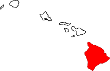
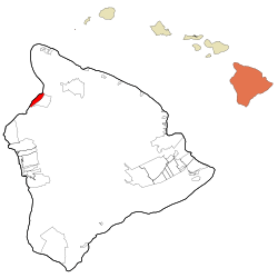 Location in Hawaii County and the state of Hawaii | |
| Coordinates: 19°58′3″N 155°50′48″W / 19.96750°N 155.84667°WCoordinates: 19°58′3″N 155°50′48″W / 19.96750°N 155.84667°W | |
| Country | United States |
| State | Hawaii |
| County | Hawaii |
| Area | |
| • Total | 15.9 sq mi (41.1 km2) |
| • Land | 10.3 sq mi (26.7 km2) |
| • Water | 5.5 sq mi (14.4 km2) |
| Elevation | 0 ft (0 m) |
| Population (2010) | |
| • Total | 772 |
| • Density | 48.5/sq mi (18.7/km2) |
| Time zone | Hawaii-Aleutian (UTC-10) |
| Area code(s) | 808 |
| FIPS code | 15-65150 |
| GNIS feature ID | 0363460 |
Puako is a census-designated place (CDP) in Hawaiʻi County, Hawaiʻi, United States. The population was 429 at the 2000 census. The epicenter of the 2006 Hawaii earthquake was some 10 km (6.2 mi) offshore of the village.
Geography
Puako is located at 19°58′3″N 155°50′48″W / 19.96750°N 155.84667°W (19.967500, -155.846667).[1]
According to the United States Census Bureau, the CDP has a total area of 15.9 square miles (41 km2), of which, 10.3 square miles (27 km2) of it is land and 5.5 square miles (14 km2) of it (34.95%) is water.
Demographics
As of the census[2] of 2000, there were 429 people, 215 households, and 118 families residing in the CDP. The population density was 41.6 people per square mile (16.1/km²). There were 702 housing units at an average density of 68.1 per square mile (26.3/km²). The racial makeup of the CDP was 71.56% White, 11.42% Asian, 4.43% Pacific Islander, and 12.59% from two or more races. Hispanic or Latino of any race were 3.26% of the population.
There were 215 households out of which 14.9% had children under the age of 18 living with them, 42.3% were married couples living together, 7.9% had a female householder with no husband present, and 45.1% were non-families. 31.6% of all households were made up of individuals and 4.7% had someone living alone who was 65 years of age or older. The average household size was 2.00 and the average family size was 2.43.

In the CDP the population was spread out with 11.7% under the age of 18, 4.9% from 18 to 24, 26.6% from 25 to 44, 41.7% from 45 to 64, and 15.2% who were 65 years of age or older. The median age was 48 years. For every 100 females there were 109.3 males. For every 100 females age 18 and over, there were 111.7 males.
The median income for a household in the CDP was $60,250, and the median income for a family was $81,176. Males had a median income of $37,500 versus $31,250 for females. The per capita income for the CDP was $63,857. None of the families and 3.1% of the population were living below the poverty line, including no under eighteens and 4.2% of those over 64.
See also
References
- ↑ "US Gazetteer files: 2010, 2000, and 1990". United States Census Bureau. 2011-02-12. Retrieved 2011-04-23.
- ↑ "American FactFinder". United States Census Bureau. Retrieved 2008-01-31.
Further reading
- Puakō: An Affectionate History (ISBN 1-894694-00-7)
External links
| Wikimedia Commons has media related to Puako, Hawaii. |