Przeworsk County
| Przeworsk County Powiat przeworski | |||
|---|---|---|---|
| County | |||
| |||
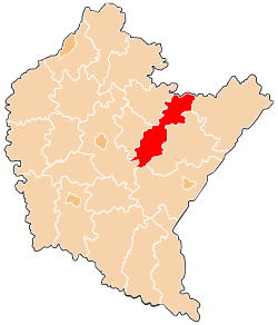 Location within the voivodeship | |||
| Coordinates (Przeworsk): 50°4′N 22°30′E / 50.067°N 22.500°ECoordinates: 50°4′N 22°30′E / 50.067°N 22.500°E | |||
| Country |
| ||
| Voivodeship |
| ||
| Seat | Przeworsk | ||
| Gminas | |||
| Area | |||
| • Total | 698.35 km2 (269.63 sq mi) | ||
| Population (2006) | |||
| • Total | 78,691 | ||
| • Density | 110/km2 (290/sq mi) | ||
| • Urban | 21,023 | ||
| • Rural | 57,668 | ||
| Car plates | RPZ | ||
| Website | http://www.powiat.przeworsk.pl | ||

Przeworsk County (Polish: powiat przeworski) is a unit of territorial administration and local government (powiat) in Subcarpathian Voivodeship, south-eastern Poland. It came into being on January 1, 1999, as a result of the Polish local government reforms passed in 1998. Its administrative seat and largest town is Przeworsk, which lies 36 kilometres (22 mi) east of the regional capital Rzeszów. The county also contains the towns of Kańczuga, lying 11 km (7 mi) south-west of Przeworsk, and Sieniawa, 15 km (9 mi) north-east of Przeworsk.
The county covers an area of 698.35 square kilometres (269.6 sq mi). As of 2006 its total population is 78,691, out of which the population of Przeworsk is 15,747, that of Kańczuga is 3,211, that of Sieniawa is 2,065, and the rural population is 57,668.
Neighbouring counties
Przeworsk County is bordered by Biłgoraj County to the north, Lubaczów County and Jarosław County to the east, Przemyśl County to the south, Rzeszów County to the south-west, and Łańcut County and Leżajsk County to the west.
Administrative division
The county is subdivided into nine gminas (one urban, two urban-rural and six rural). These are listed in the following table, in descending order of population.
| Gmina | Type | Area (km²) |
Population (2006) |
Seat |
| Przeworsk | urban | 22.0 | 15,747 | |
| Gmina Przeworsk | rural | 91.0 | 14,479 | Przeworsk * |
| Gmina Kańczuga | urban-rural | 105.2 | 12,726 | Kańczuga |
| Gmina Tryńcza | rural | 70.6 | 8,186 | Tryńcza |
| Gmina Zarzecze | rural | 49.2 | 7,174 | Zarzecze |
| Gmina Sieniawa | urban-rural | 127.3 | 6,806 | Sieniawa |
| Gmina Jawornik Polski | rural | 62.9 | 4,803 | Jawornik Polski |
| Gmina Gać | rural | 36.0 | 4,562 | Gać |
| Gmina Adamówka | rural | 134.3 | 4,208 | Adamówka |
| * seat not part of the gmina | ||||
References
Seat: Przeworsk (urban gmina) | ||
| Urban-rural gminas |  | |
| Rural gminas | ||
| City counties |
|  |
|---|---|---|
| Land counties | ||