Prudence Island
Coordinates: 41°37′01″N 71°18′59″W / 41.6170°N 71.3164°W


Prudence Island is the third largest island in Narragansett Bay in the U.S. state of Rhode Island and part of the town of Portsmouth. It is located near the geographical center of the bay. It is defined by the United States Census Bureau as Block Group 3, Census Tract 401.03 of Newport County, Rhode Island. As of the 2000 census the population was 88 people living on a land area of 14.43 km² (5.57 sq mi).[1]
History
The Native American name for the island was "Chibachuweset" (or "Chibachuwese"), and the Narragansetts originally offered it for sale to John Oldham if he would settle there and set up a trading post. Oldham failed to meet the condition, so in 1637 the Narragansetts sold the island to Roger Williams and John Winthrop with each man retaining a one-half interest: Roger Williams took the northern side of the island while John Winthrop took the southern side. Division wall divides the two sides. Pulpit Rock can still be found today on the northern side of the island. Williams and Winthrop hoped to farm pigs on the island. Williams named the island "Prudence" and shortly afterwards purchased and named nearby Patience Island and Hope Island. Williams sold his half interest in Prudence Island while in England on behalf of the colony, and Winthrop willed his land to his son Stephen.[2][3]
In colonial times, the island was used mainly for farming. During the American Revolution, the British forces under Captain James Wallace raided Prudence Island for livestock and engaged in a skirmish with American forces, losing approximately a dozen soldiers. In the 20th century, farming began to decline and the island began to attract summer residences. In World War II, the U.S. Navy established an ammunition depot on the 400 acres (1.6 km2) southernmost of the island. In 1972, the Navy turned the base over to the state of Rhode Island, leaving bunkers, roads, and a large deep-water pier.
Along with nearby Hope Island and Patience Island, the former Naval Base is now home to the Narragansett Bay National Estuarine Research Reserve, as well as the former Garland Estate on the northernmost part of the island. The Farnham Farm is a national historic site. The island is served by ferry service to Bristol, Rhode Island. Parts of the 2012 film, Moonrise Kingdom, were filmed on the island and nearby Jamestown, Rhode Island.[4]
Summer colonies on Prudence Island
There are several different summer colonies on the island, named after either their plat names or by the original owner of the land / subdivision. These are in order from the south:
- Prudence Park- Located on the west side of the island at the western end of Broadway. Development began in 1872 with the building of the Stone Wharf on the west side of the island which became a stop on the Fall River Line steamers running from Providence and Fall River to New York. Most of the summer homes in this area of the island are fine examples of Victorian and Beaux Arts summer homes, in a similar style to those at Oak Bluffs, Martha's Vineyard. The Stone Wharf was severely damaged and many houses were lost in the Hurricane of 1938.[5]
- Bristol Colony- Located on the east side of the island at the eastern end of Broadway. A more modern summer colony, near the site of Bullock's Warf from the 1840s.[5]
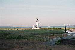
- Sandy Point- Located on the eastern side of the island, along Narragansett Avenue. Site of Prudence Island Light (commonly known as "Sandy Point Light"), the Town Dock and a former landing point for the ferry.
- Homestead- Plat of summer homes along the east coast of the island, north of Pier Road, to the north of the former Homestead Casino which was lost in the Hurricane of 1938, now the site of the island's post office, general store, and ferry landing.
- Warnerville- Located directly north of the Homestead Plat, on Warner Avenue off Narragansett Avenue.
- Boystown Fly-In Ranch Airport is located on the northern part of the island.[6]
References
- ↑ Block Group 3, Census Tract 401.03, Newport people have to take a ferry every day to get off and that is not easy County United States Census Bureau
- ↑ Letters of Roger Williams. 1632-1682. Now first collected, Oct. 28 1637, (Providence: Printed for the Narragansett Club, 1874) pg. 70 (accessed through The Library 0f Congress on July 19, 2009)
- ↑ Samuel Greene Arnold, History of the state of Rhode Island and Providence plantations Volume 1, (D. Appleton, 1859) pg. 105
- ↑ http://www.newportri.com/features/film/enchanted-kingdom/article_af6edf4e-af3f-11e1-98ac-001a4bcf887a.html
- 1 2 Chippaquasett: Indian Name of Prudence Island, Circa 1895 (Map). Cartography by Francis Curran. Unknown. 1970.
- ↑ https://plus.google.com/114384744629732154078/about?gl=us&hl=en
| Islands |  | |
|---|---|---|
| Major rivers | ||
| Cities & towns | ||
| Bridges | ||