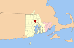
Providence metropolitan area
| Providence Metropolitan Area | |
|---|---|
| Providence–New Bedford–Fall River | |
 | |
| Country | United States |
| State(s) |
- Rhode Island - Massachusetts |
| Largest city | Providence |
| Other cities |
- New Bedford - Fall River - Warwick - North Kingstown |
| Area | |
| • Total | 1,635.76 sq mi (4,236.6 km2) |
| Highest elevation | 812 ft (247.5 m) |
| Lowest elevation | 0 ft (0 m) |
| Population (2005 est.) | |
| • Total | 1,612,989 |
| • Rank | 35th in the U.S. |
| • Density | 1,006.21/sq mi (2,606.07/km2) |
The Providence metropolitan area is a region extending into eight counties in two states, and is the 39th largest metropolitan area in the United States.[1][2] Anchored by the city of Providence, Rhode Island, it has an estimated population of 1,622,520, exceeding that of Rhode Island by slightly over 60%. The area covers almost all of Rhode Island. 38 of the 39 municipalities in the state are included. Only Westerly is not. The Providence Metropolitan Statistical Area also extends into southern Massachusetts with an average population density of 2300 per mi² (888 per km²).[3][4][5] Its Gross Metropolitan Product is the country's 42nd largest at $64.7 billion, just above the Gross State Product of the entire state of Hawaii.[6]
In 2006, this area was officially added to the Boston Combined Statistical Area (CSA), the fifth-largest CSA in the country.[1]
In 2004, Smart Growth America named the New York City metro area the "Least Sprawling" metropolitan area in the country, though Wendell Cox, correcting for the fact that this is only true when New Jersey's and Connecticut's contributions are ignored, asserts that this title should belong to the Providence metropolitan area. Cox makes clear, however, that he is criticizing the definitional criteria of "sprawl" developed by Smart Growth America, satirically pointing out the incongruity of Providence winning the crown when, for example, only 0.4% of transportation uses mass transit.[4]
Boundaries
The Providence metropolitan area contains towns from all five counties in Rhode Island and one county in Massachusetts, including:
- Bristol County, Rhode Island
- Kent County, Rhode Island
- Newport County, Rhode Island
- Providence County, Rhode Island
- Washington County, Rhode Island
- Bristol County, Massachusetts
The New Bedford metro area is not included in the Providence NECTA, but is included in the Combined NECTA[7] and MSA definitions.
Principal Cities
- Providence, Rhode Island
- Fall River, Massachusetts
- New Bedford, Massachusetts
- Warwick, Rhode Island
- Cranston, Rhode Island
Transportation
The Massachusetts Bay Transportation Authority (MBTA) operates a commuter rail connecting the metropolitan area to Boston. There are commuter rail stations in Providence, South Attleboro, and Attleboro. An extension of the commuter rail to T.F. Green airport in Warwick and Wickford Junction in North Kingstown, Rhode Island was completed in 2012. Extensions to Fall River and New Bedford have also been planned. Amtrak provides regional rail service to the Providence and Kingston train stations as well.
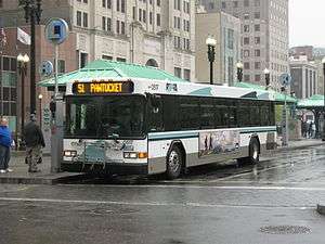
Rhode Island Public Transit Authority (RIPTA), which has its hub in downtown Providence manages local bus transit for the state, serving 35 out of 39 Rhode Island communities. RIPTA operates 55 bus lines as well as Flex service and paratransit service.[8] Ferry services link Block Island, Prudence Island, and Hog Island to the Rhode Island mainland. Southeastern Regional Transit Authority (SRTA) provides local bus service in the Massachusetts locales of Fall River and New Bedford. Greater Attleboro Transit Authority (GATRA) serves the Attleboros and surrounding towns. It also provides connections to RIPTA in Pawtucket, R.I.
The major airport is T. F. Green Airport in Warwick, though Logan International Airport in Boston is also used. The MBTA Providence/Stoughton Line passes through T.F. Green and connects the airport to Providence and Boston, offering additional airport flexibility in the Greater Boston Area.
Two interstates connect major population centers in the region: 95, which runs diagonally across Rhode Island, and 195, which runs east from Providence into Massachusetts. The auxiliary interstate 295 provides a bypass around Providence.
Demographics
| Historical population | |||
|---|---|---|---|
| Census | Pop. | %± | |
| 1990 | 1,134,350 | — | |
| 2000 | 1,188,613 | 4.8% | |
| Est. 2007 | 1,600,856 | [9] | |
| data source:[2][10] | |||
The Metro Area is marked by large populations of Irish-American, Italian-American, and French Canadians French-American throughout the region. The Irish form the largest group in Newport, and Washington Counties. The Italians in Kent, and southern Providence County. the French in northern and western Providence county. All groups however can be found throughout the region in large numbers.
Also included are very large concentrations of Lusophone populations across the region with the largest density being from East Providence to New Bedford. The two Bristol counties (RI, and MA) are the only two counties in America where Portuguese-Americans form a plurality of the Population.[11]
Pockets of English and Scots-Irish Americans are found in rural areas of the region such as South County where they are known locally as "Swamp Yankees", and also in towns such as Barrington, East Greenwich and the East Side of Providence.
Other Groups include Poles, Swedes, Germans, Greeks, Armenians, Jews, and Arabs (especially Lebanese and Syrians).
More recent immigrant groups include continued migrations from Portugal, Cape Verde, Brazil, and other Lusophone nations, South East Asia specifically Laos, Cambodia, Hmong (mostly from Vietnam), small but growing Chinese, Japanese and Korean populations, and the former Soviet Union.
However, the largest group of recent immigrants has been Latino. The Latino population is very diverse with older populations of Puerto Ricans (many 3rd and 4th generation) being joined more recently by significant and growing Dominican, Guatemalan, Salvadorian, Mexican, Colombian, Venezuelan and Bolivian communities. Providence, RI holds the distinction of being the first city where a native born Dominican was elected to the Senate in the state of Rhode Island.
References
- 1 2 "Update of Statistical area Definitions and Guidance on Their Uses" (PDF). whitehouse.gov. pp. 52,108,150. Archived from the original (PDF) on June 4, 2007. Retrieved June 11, 2007.
- 1 2 "Providence Metropolitan Area:2000–2005 Population & Migration". demographia.com. Retrieved June 11, 2007.
- ↑ "July 1, 2005 Population Estimates". US Census Bureau. Retrieved March 22, 2007.
- 1 2 Wendell Cox. "Providence: Least Sprawling Metropolitan Area: Colorado Springs Sprawls less than Portland" (PDF). publicpurpose.com. Retrieved June 11, 2007.
- ↑ "May 2006 OEC Metropolitan Statistical Area definitions". stats.bls.gov. Retrieved June 9, 2007.
- ↑ http://www.usmayors.org/metroeconomies/0608/GMP_Report__June_2008.pdf pages 15 and 40
- ↑ Current Lists of Metropolitan and Micropolitan Statistical Areas and Definitions
- ↑ "About". RIPTA. Rhode Island Public Transit Authority. Retrieved 4 September 2015.
- ↑ Estimates of Population Change for Metropolitan Statistical Areas and Rankings: July 1, 2005 to July 1, 2006
- ↑ http://www.census.gov/population/www/cen2000/briefs/phc-t3/index.html
- ↑ Bristol County, Massachusetts – Select a Race, Ethnic, or Ancestry Group – American FactFinder
Federation of American Immigrant Reform demographic figures
Providence (capital) | |
| Topics |
|
| Society |
|
| Regions | |
| Cities | |
| Towns |
|
Boston (capital) | |
| Topics |
|
| Society | |
| Regions | |
| Counties | |
| Cities |
|