Providence River
| Providence River | |
|---|---|
| Basin | |
| Main source |
confluence of Woonasquatucket and Moshassuck Rivers 41°49′36″N 71°24′36″W / 41.8267°N 71.4100°W |
| River mouth |
Narragansett Bay 41°43′16″N 71°20′53″W / 41.721°N 71.348°WCoordinates: 41°43′16″N 71°20′53″W / 41.721°N 71.348°W |
| Physical characteristics | |
| Length | 8 mi (13 km) |


The Providence River is a tidal river in the U.S. state of Rhode Island. It flows approximately 8 miles (13 km). There are no dams along the river's length, although the Fox Point Hurricane Barrier is located south of downtown, to protect the city of Providence from damaging tidal floods.
The southern part of the river has been dredged at a cost of $65 million in federal and state funds to benefit nearby marinas and commercial shipping interests.[1]
Owing to Adriaen Block's exploration of Narragansett Bay, the Providence River (which the Dutch called the Nassau River) was the northeastern limit of Dutch claims in the colonial era from 1614 until the Hartford Treaty of 1650 and can therefore be regarded as the original boundary between the English New England colonies and the Dutch colony of New Netherland.
Course
The river is formed by the confluence of the Woonasquatucket and Moshassuck rivers in downtown Providence. One half mile downstream, it is joined from the east by the Seekonk River and continues south. The cities of Providence, Cranston, and Warwick lie to the west of the river, while the city of East Providence and the town of Barrington lie to the east. At the narrows between Conimicut Point, in Warwick to the west and Nayatt Point in Barrington to the east, the Conimicut Shoal Lighthouse marks the entrance to the river from Narragansett Bay.
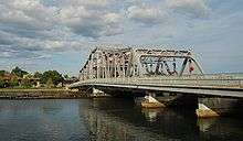
Crossings
Below is a list of all crossings over the Providence River. The list starts at the headwaters and goes downstream.
- Providence
- Washington Place
- College Street
- Crawford Street
- Old Interstate 195
- Point Street Bridge
- Fox Point Hurricane Barrier
- Providence River Bridge (I-195)
Tributaries
See also
References
- Maps from the United States Geological Survey
- Providence.edu Providence River Dredging Project Answer Sheet
- crmc.state.ri.us Providence River Dredging Project: Breaking the Impasse through Partnering
- ↑ crmc.state.ri.us Providence River Dredging Project: Breaking the Impasse through Partnering
| Islands |  | |
|---|---|---|
| Major rivers | ||
| Cities & towns | ||
| Bridges | ||