Princeville, Hawaii
| Princeville, Hawaii | |
|---|---|
| Census-designated place | |
| Coordinates: 22°13′25″N 159°29′7″W / 22.22361°N 159.48528°WCoordinates: 22°13′25″N 159°29′7″W / 22.22361°N 159.48528°W | |
| Country | United States |
| State | Hawaii |
| County | Kauai |
| Area | |
| • Total | 2.4 sq mi (6.2 km2) |
| • Land | 2.1 sq mi (5.5 km2) |
| • Water | 0.3 sq mi (0.7 km2) |
| Elevation | 194 ft (59 m) |
| Population (2010) | |
| • Total | 2,158 |
| • Density | 806.7/sq mi (311.5/km2) |
| Time zone | Hawaii-Aleutian (UTC-10) |
| ZIP codes | 96714, 96722 |
| Area code(s) | 808 |
| FIPS code | 15-65075 |
| GNIS feature ID | 1867259 |
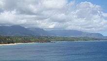
Princeville is a 9,000-acre (3,600 ha), upscale, unincorporated, master-planned community of vacation homes and condos on the north shore of the island of Kauai in Kauai County, Hawaii. The population was 2,158 in the 2010 census. For statistical purposes, the United States Census Bureau has defined Princeville as a census-designated place (CDP). The census definition of the area may not precisely correspond to local understanding of the area with the same name.
Geography
Princeville is at 22°13′25″N 159°29′7″W / 22.22361°N 159.48528°W (22.223513, -159.485392).[1] It is the northernmost settlement in the state of Hawaii.[2]
According to the United States Census Bureau, the CDP has a total area of 2.4 square miles (6.2 km2), of which, 2.1 square miles (5.4 km2) of it is land and 0.3 square miles (0.78 km2) of it (11.76%) is water.
History
The area was named in honor of an 1860 visit by Prince Albert Kamehameha, son of King Kamehameha IV and Queen Emma. It was then a plantation owned by Robert Crichton Wyllie.[3] He named another part of the plantation Emmaville, but that name never stuck.[4] Originally the land was planted with coffee which was not suited to the wet lowlands. It was then planted with sugarcane. Wyllie's nephew Robert Crichton Cochran inherited the land under the condition he would adopt the Wyllie surname, but he committed suicide on February 7, 1866. In 1867 it was purchased by Elisha Hunt Allen and later became a cattle ranch.[5][6] It was sold for development in 1968 and became a golf course and resort called Princeville at Hanalei.[7]
Demographics
As of the census[8] of 2000, there were 1,698 people, 752 households, and 491 families residing in the CDP. The population density was 806.7 people per square mile (312.2/km²). There were 1,640 housing units at an average density of 779.1 per square mile (301.5/km²). The racial makeup of the CDP was 81.3% White, 0.3% African American, 0.5% Native American, 4.6% Asian, 3.4% Pacific Islander, 1.0% from other races, and 9.0% from two or more races. Hispanic or Latino of any race were 4.0% of the population.
There were 752 households out of which 23.4% had children under the age of 18 living with them, 53.5% were married couples living together, 9.2% had a female householder with no husband present, and 34.7% were non-families. 26.1% of all households were made up of individuals and 6.6% had someone living alone who was 65 years of age or older. The average household size was 2.26 and the average family size was 2.70.
In the CDP the population was spread out with 19.3% under the age of 18, 3.4% from 18 to 24, 25.3% from 25 to 44, 35.6% from 45 to 64, and 16.4% who were 65 years of age or older. The median age was 46 years. For every 100 females there were 100.7 males. For every 100 females age 18 and over, there were 100.3 males.
The median income for a household in the CDP was $63,833, and the median income for a family was $67,266. Males had a median income of $48,229 versus $29,542 for females. The per capita income for the CDP was $37,971. About 7.4% of families and 8.1% of the population were below the poverty line, including 11.5% of those under age 18 and 4.3% of those age 65 or over.
See also
References
- ↑ "US Gazetteer files: 2010, 2000, and 1990". United States Census Bureau. 2011-02-12. Retrieved 2011-04-23.
- ↑ "EXTREME SETTLEMENTS: A COMPREHENSIVE LIST". Weekend Roady. 2013-05-02. Retrieved 2014-08-20.
- ↑ Mary Kawena Pukui and Elbert (2004). "lookup of Wyllie". on Place Names of Hawai'i. Ulukau, the Hawaiian Electronic Library, University of Hawaii. Retrieved 2010-03-15.
- ↑ Edward Joesting (1988). Kauai: The Separate Kingdom. University of Hawaii Press. pp. 180–187. ISBN 978-0-8248-1162-4.
- ↑ Rhoda E. A. Hackler (1982). "Princeville Plantation Papers". Hawaiian Journal of History. 16. Hawaii Historical Society. pp. 65–85. hdl:10524/630.
- ↑ "Suicide". The Pacific Commercial Advertiser. X (33). Honolulu. February 17, 1866. p. 2. Retrieved August 5, 2015.
- ↑ Mary Kawena Pukui and Elbert (2004). "lookup of Princeville". on Place Names of Hawai'i. Ulukau, the Hawaiian Electronic Library, University of Hawaii. Retrieved 2010-03-15.
- ↑ "American FactFinder". United States Census Bureau. Archived from the original on 2013-09-11. Retrieved 2008-01-31.
External links
- "A Rich History". Princeville at Hanalei web site. 2010. Retrieved 2010-03-15.
Islands, municipalities, and communities of Kauai County, Hawaii, United States | ||
|---|---|---|
| CDPs | 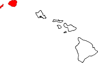 | |
| Unincorporated communities | ||