Princeton Township, New Jersey
| Princeton Township, New Jersey | |
|---|---|
| Township | |
| Township of Princeton | |
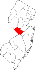
 Census Bureau map of Princeton Township, New Jersey | |
| Coordinates: 40°21′26″N 74°40′13″W / 40.357115°N 74.670165°WCoordinates: 40°21′26″N 74°40′13″W / 40.357115°N 74.670165°W | |
| Country |
|
| State |
|
| County | Mercer |
| Settled | 1683 |
| Incorporated | April 9, 1838 |
| Government[1] | |
| • Type | Township |
| • Body | Township Committee |
| • Mayor | Chad Goerner (D, term ended December 31, 2012)[2][3] |
| • Administrator | Kathryn Monzo (acting)[4] |
| • Clerk | Linda McDermott[5] |
| Area[6] | |
| • Total | 16.520 sq mi (42.786 km2) |
| • Land | 16.090 sq mi (41.672 km2) |
| • Water | 0.430 sq mi (1.114 km2) 2.60% |
| Area rank |
167th of 566 in state 6th of 13 in county[6] |
| Elevation[7] | 200 ft (61 m) |
| Population (2010 Census)[8][9][10] | |
| • Total | 16,265 |
| • Rank |
154th of 566 in state 8th of 13 in county |
| • Density | 1,010.9/sq mi (390.3/km2) |
| • Density rank |
379th of 566 in state 11th of 13 in county |
| Time zone | Eastern (EST) (UTC-5) |
| • Summer (DST) | Eastern (EDT) (UTC-4) |
| ZIP codes | 08540-08544[11] |
| Area code(s) | 609 |
| FIPS code | 3402160915[6][12][13] |
| GNIS feature ID | 0882125[6][14] |
| Website |
www |
Princeton Township was a township in Mercer County, New Jersey, United States, that existed from 1838 until it was dissolved after it was merged with Princeton Borough in 2013 to form Princeton, New Jersey. As of the 2010 United States Census, the township's population was 16,265,[8][9][10] reflecting an increase of 238 (+1.5%) from the 16,027 counted in the 2000 Census, which had in turn increased by 2,829 (+21.4%) from the 13,198 counted in the 1990 Census.[15]
Princeton was incorporated as a township by an act of the New Jersey Legislature on April 9, 1838, from portions of West Windsor Township in Mercer County and Montgomery Township in Somerset County. The Borough of Princeton — created on February 11, 1813 within the area that later became Princeton Township — became a fully independent municipality circa 1894. Portions of territory were ceded to the Borough of Princeton on January 4, 1928 and August 21, 1951.[16] On November 8, 2011, voters in Princeton Township voted to consolidate with Princeton Borough, a change that took effect on January 1, 2013.[17]
The Institute for Advanced Study, a private research institution that has been an academic home to Albert Einstein, Kurt Gödel, and many other famous and prize-winning scientists, is located in the former township. Princeton University is located mostly within the former borough, but parts of the campus extended into what was Princeton Township.
Drumthwacket, the official residence of the Governor of New Jersey, is located at 344 Stockton Street in the area of the former township.[18]
The last day Princeton Township existed as an independent municipality was December 31, 2012.
Geography
According to the United States Census Bureau, the township had a total area of 16.520 square miles (42.786 km2), including 16.090 square miles (41.672 km2) of it is land and 0.430 square miles (1.114 km2) of water (2.60%) is water.[6][19]
Princeton Borough was an independent municipality completely surrounded by the township.
Princeton North was an unincorporated community located within Princeton Township that had been a census-designated place until the 2010 Census.[20]
The Princeton Airport is within Princeton's postal district but is situated less than a mile across the Somerset County border, in Montgomery Township.
Demographics
| Historical population | |||
|---|---|---|---|
| Census | Pop. | %± | |
| 1870 | 1,188 | — | |
| 1880 | 1,139 | −4.1% | |
| 1890 | 809 | −29.0% | |
| 1900 | 955 | 18.0% | |
| 1910 | 1,178 | 23.4% | |
| 1920 | 1,424 | 20.9% | |
| 1930 | 2,738 | 92.3% | |
| 1940 | 3,251 | 18.7% | |
| 1950 | 5,407 | 66.3% | |
| 1960 | 10,411 | 92.5% | |
| 1970 | 13,651 | 31.1% | |
| 1980 | 13,683 | 0.2% | |
| 1990 | 13,198 | −3.5% | |
| 2000 | 16,027 | 21.4% | |
| 2010 | 16,265 | 1.5% | |
| Est. 2011 | 16,304 | [21] | 0.2% |
| Population sources: 1870[22] 1880-1890[23] 1890-1910[24] 1910-1930[25] 1930-1990[26] 2000[27][28] 2010[8][9][10] | |||
Census 2010
The 2010 United States Census counted 16,265 people, 6,360 households, and 4,325 families residing in the township. The population density was 1,010.9 per square mile (390.3/km2). The township contained 6,814 housing units at an average density of 423.5 per square mile (163.5/km2). The racial makeup of the township was 75.52% (12,283) White, 4.98% (810) Black or African American, 0.14% (22) Native American, 14.17% (2,305) Asian, 0.02% (4) Pacific Islander, 2.26% (368) from other races, and 2.91% (473) from two or more races. Hispanics or Latinos of any race were 6.91% (1,124) of the population.[8]
Out of a total of 6,360 households, 31.4% had children under the age of 18 living with them, 59.1% were married couples living together, 7.0% had a female householder with no husband present, and 32.0% were non-families. 23.6% of all households were made up of individuals, and 8.8% had someone living alone who was 65 years of age or older. The average household size was 2.52 and the average family size was 3.02.[8]
In the township, 23.1% of the population were under the age of 18, 6.5% from 18 to 24, 23.7% from 25 to 44, 29.7% from 45 to 64, and 17.0% who were 65 years of age or older. The median age was 42.6 years. For every 100 females the census counted 94.0 males, but for 100 females at least 18 years old, it was 90.8 males.[8]
The Census Bureau's 2006-2010 American Community Survey showed that (in 2010 inflation-adjusted dollars) median household income was $107,071 (with a margin of error of +/- $12,828) and the median family income was $149,948 (+/- $16,625). Males had a median income of $112,282 (+/- $7,079) versus $66,150 (+/- $11,617) for females. The per capita income for the borough was $71,050 (+/- $6,509). About 6.2% of families and 7.7% of the population were below the poverty line, including 6.1% of those under age 18 and 6.2% of those age 65 or over.[29]
Census 2000
As of the 2000 United States Census[12] there were 16,027 people, 6,044 households, and 4,357 families residing in the township. The population density was 978.2 people per square mile (377.8/km²). There were 6,224 housing units at an average density of 379.9 per square mile (146.7/km²). The racial makeup of the township was 79.91% White, 5.32% African American, 0.12% Native American, 9.98% Asian, 0.05% Pacific Islander, 2.11% from other races, and 2.51% from two or more races. Hispanic or Latino of any race were 5.28% of the population.[27][28]
There were 6,044 households out of which 34.1% had children under the age of 18 living with them, 63.3% were married couples living together, 7.2% had a female householder with no husband present, and 27.9% were non-families. 20.6% of all households were made up of individuals and 8.2% had someone living alone who was 65 years of age or older. The average household size was 2.57 and the average family size was 2.98.[27][28]
In the township the population was spread out with 24.4% under the age of 18, 5.1% from 18 to 24, 27.4% from 25 to 44, 27.7% from 45 to 64, and 15.4% who were 65 years of age or older. The median age was 41 years. For every 100 females there were 93.6 males. For every 100 females age 18 and over, there were 90.6 males.[27][28]
The median income for a household in the township was $94,580, and the median income for a family was $123,098. Males had a median income of $77,845 versus $41,563 for females. The per capita income for the township was $56,360. About 4.2% of families and 5.7% of the population were below the poverty line, including 5.7% of those under age 18 and 3.0% of those age 65 or over.[27][28]
As of the 2000 Census, Princeton Township was the 25th-wealthiest community in the state of New Jersey with a per capita money income of $56,360 as of 1999, an increase of 41.7% from the $39,767 recorded in 1989 when it was ranked 21st in the state.[30]
Government
Local government
Princeton Township was governed under the Township form of government with a five-member Township Committee led by. The Township Committee was elected directly by the voters in partisan elections to serve three-year terms of office on a staggered basis, with one seat coming up for election each year.[1] A Mayor and Deputy Member were elected by the Committee from among its members and serve a one-year term. The Mayor served as the Chairperson of the Committee and exercised executive powers vested in the Mayor's Office by law. All legislative powers were assigned to the Committee. 104 of the 565 municipalities in New Jersey operate with a five-member Committee form of local government.[31]
An Administrator was also empowered by ordinance to serve in an executive capacity and direct the Township's day-to-day operations.[4]
Members of the final Princeton Township Committee were Mayor Chad Goerner (D, term ends December 31, 2012), Deputy Mayor Liz Lempert (D, 2013), Lance Liverman (D, 2013), Bernard P. Miller (D, 2014) and Sue Nemeth (D, 2014).[2][31]
Merger of Borough and Township
On November 8, 2011, the residents of both the Borough of Princeton and the Township of Princeton voted to merge the two municipalities into one. In Princeton Borough 1,385 voted for, 902 voted against while in Princeton Township 3,542 voted for and 604 voted against. Proponents of the consolidation measure asserted that when the merger is completed, the new municipality of Princeton will save $3.2 million as a result of some scaled-down services, including layoffs of 15 government workers, including 9 police officers (however, the measure itself does not create any line item cost reduction or layoffs). Opponents to the consolidation measure asserted that cost savings alleged by a widely circulated report were incorrect and/or unsubstantiated and that individual voter representation would be diluted by the merged municipal structure.[17] The consolidation is to take effect in 2013.[32] The last day Princeton Township existed as a municipality was December 31, 2012.
Federal, state and county representation
Princeton Township was located in the 12th Congressional district[33] and was part of New Jersey's 16th state legislative district.[9][34] Prior to the 2011 reapportionment following the 2010 Census, Princeton Township had been in the 15th state legislative district.[33]
New Jersey's Twelfth Congressional District is represented by Bonnie Watson Coleman (D, Ewing Township).[35] New Jersey is represented in the United States Senate by Cory Booker (D, Newark, term ends 2021)[36] and Bob Menendez (D, Paramus, 2019).[37][38]
For the 2016–2017 session (Senate, General Assembly), the 16th Legislative District of the New Jersey Legislature is represented in the State Senate by Christopher Bateman (R, Branchburg) and in the General Assembly by Jack Ciattarelli (R, Hillsborough Township) and Andrew Zwicker (D, South Brunswick). [39] The Governor of New Jersey is Chris Christie (R, Mendham Township).[40] The Lieutenant Governor of New Jersey is Kim Guadagno (R, Monmouth Beach).[41]
Mercer County is governed by a County Executive who oversees the day-to-day operations of the county and by a seven-member Board of Chosen Freeholders that acts in a legislative capacity, setting policy. All officials are chosen at-large in partisan elections, with the executive serving a four-year term of office while the freeholders serve three-year terms of office on a staggered basis, with either two or three seats up for election each year.[42] As of 2014, the County Executive is Brian M. Hughes (D, term ends December 31, 2015; Princeton).[43] Mercer County's Freeholders are Freeholder Chair Andrew Koontz (D, 2016; Princeton),[44] Freeholder Vice Chair Samuel T. Frisby, Sr. (2015; Trenton),[45] Ann M. Cannon (2015; East Windsor Township),[46] Anthony P. Carabelli (2016; Trenton),[47] John A. Cimino (2014, Hamilton Township),[48] Pasquale "Pat" Colavita, Jr. (2015; Lawrence Township)[49] and Lucylle R. S. Walter (2014; Ewing Township)[50][51][52] Mercer County's constitutional officers are County Clerk Paula Sollami-Covello (D, 2015),[53] Sheriff John A. Kemler (D, 2014)[54] and Surrogate Diane Gerofsky (D, 2016).[55][56]
Politics
As of March 23, 2011, there were a total of 11,488 registered voters in Princeton Township, of which 5,691 (49.5%) were registered as Democrats, 1,520 (13.2%) were registered as Republicans and 4,263 (37.1%) were registered as Unaffiliated. There were 14 voters registered to other parties.[57]
In the 2008 presidential election, Democrat Barack Obama received 75.3% of the vote here (6,963 cast), ahead of Republican John McCain with 20.7% (1,914 votes) and other candidates with 1.1% (103 votes), among the 9,247 ballots cast by the township's 12,423 registered voters, for a turnout of 74.4%.[58] In the 2004 presidential election, Democrat John Kerry received 70.6% of the vote here (6,276 ballots cast), outpolling Republican George W. Bush with 25.8% (2,295 votes) and other candidates with 1.0% (111 votes), among the 8,894 ballots cast by the township's 11,190 registered voters, for a turnout percentage of 79.5.[59]
In the 2009 gubernatorial election, Democrat Jon Corzine received 66.1% of the vote here (3,867 ballots cast), ahead of Republican Chris Christie with 26.9% (1,576 votes), Independent Chris Daggett with 5.8% (342 votes) and other candidates with 0.5% (29 votes), among the 5,854 ballots cast by the township's 11,777 registered voters, yielding a 49.7% turnout.[60]
Education
Colleges and universities
Part of Princeton University, including most of the athletic facilities, was in the township. Most university buildings were in the borough. The rest of the university's land is across Carnegie Lake in West Windsor Township.
The Princeton Theological Seminary and the Institute for Advanced Study were in the township.
Westminster Choir College was located mainly in the borough; a small part was in the township.
Mercer County Community College served residents of the township.
Primary and secondary schools
Public schools

For grades K through 12, public school students attend the Princeton Regional Schools, a regional school district shared with Princeton Borough that also serves students from Cranbury Township, as part of a sending/receiving relationship.[61] Schools in the district (with 2010-11 enrollment data from the National Center for Education Statistics[62]) are Community Park Elementary School (grades K-5, 321 students; located in Princeton Township), Johnson Park Elementary School (K-5, 372; Princeton Township), Littlebrook Elementary School (K-5, 335; Princeton Township), Riverside Elementary School (K-5, 276; Princeton Township), John Witherspoon Middle School (6-8, 664; Princeton Township) and Princeton High School (9-12, 1,420; Borough of Princeton).[63]
The Princeton Charter School, located in the township, opened in September 1997 and serves students from the borough and township who are selected by lottery from among applicants.[64][65]
Private schools
Several private schools are located in the Township, including the American Boychoir School, Hun School of Princeton, Princeton Academy of the Sacred Heart, Princeton Day School, Princeton Friends School, and Stuart Country Day School.
Public libraries
The Princeton Public Library, located in the borough, serves the borough and the township. The library was entirely rebuilt in 2004 at its downtown location at the corner of Witherspoon Street and Wiggins Street and opened its doors in April of that year.
Points of interest
- The site of the Mercer Oak, against which the dying General Hugh Mercer rested while his men around him continued to fight the Battle of Princeton in 1777. The oak is the emblem of Princeton Township[66] and appears on the seal of Mercer County. The tree died in 2000, and one of its saplings now grows in its place.
- The Washington Oak - 275+ year-old white oak overlooking Princeton Battlefield State Park on the spot where British and American forces first saw each other.
- Delaware and Raritan Canal - runs along the Stony Brook and the eastern bank of Carnegie Lake.
- Stony Brook Meeting House and Cemetery - historic sites of 18th century meeting house and burial site of Richard Stockton (signer of the Declaration of Independence) and Governor of New Jersey Charles Smith Olden.
- Drumthwacket - official residence of the Governor of New Jersey
Sister cities
See also
References
- 1 2 2012 New Jersey Legislative District Data Book, Rutgers University Edward J. Bloustein School of Planning and Public Policy, March 2013, p. 103.
- 1 2 Elected Officials, p. 14. Mercer County, New Jersey, Revised January 26, 2012. Accessed November 20, 2012.
- ↑ 2012 New Jersey Mayors Directory, New Jersey Department of Community Affairs, August 9, 2012. Accessed November 20, 2012. As of the date accessed, a term-end year of 2011 is listed for Chad Goerner.
- 1 2 Administration, Princeton Township. Accessed August 20, 2012.
- ↑ Office of the Township Clerk, Princeton Township. Accessed August 20, 2012.
- 1 2 3 4 5 Gazetteer of New Jersey Places, United States Census Bureau. Accessed October 23, 2012.
- ↑ U.S. Geological Survey Geographic Names Information System: Township of Princeton, Geographic Names Information System. Accessed August 20, 2012.
- 1 2 3 4 5 6 DP-1 - Profile of General Population and Housing Characteristics: 2010 for Princeton township, Mercer County, New Jersey, United States Census Bureau. Accessed August 20, 2012.
- 1 2 3 4 Municipalities Grouped by 2011-2020 Legislative Districts, New Jersey Department of State, p. 8. Accessed August 20, 2012.
- 1 2 3 Profile of General Demographic Characteristics: 2010 for Princeton township, New Jersey Department of Labor and Workforce Development. Accessed August 20, 2012.
- ↑ Look Up a ZIP Code for Princeton, NJ, United States Postal Service. Accessed August 20, 2012.
- 1 2 American FactFinder, United States Census Bureau. Accessed September 4, 2014.
- ↑ A Cure for the Common Codes: New Jersey, Missouri Census Data Center. Accessed August 20, 2012.
- ↑ US Board on Geographic Names, United States Geological Survey. Accessed September 4, 2014.
- ↑ Table 7. Population for the Counties and Municipalities in New Jersey: 1990, 2000 and 2010, New Jersey Department of Labor and Workforce Development, February 2011. Accessed August 20, 2012.
- ↑ Snyder, John P. The Story of New Jersey's Civil Boundaries: 1606-1968, Bureau of Geology and Topography; Trenton, New Jersey; 1969. p. 164. Accessed August 24, 2012.
- 1 2 Clerkin, Bridget (November 8, 2011). "Princeton voters approve consolidation of borough, township into one municipality". The Times. Trenton, NJ. Retrieved November 9, 2011.
- ↑ Halbfinger, David M. "Governors Don’t Call This Home", The New York Times, November 19, 2009. Accessed August 20, 2012. "It is a 20-room Greek Revival mansion, with Italian gardens, a music room and a wood-paneled library. But no one seems to want to live in Drumthwacket, the governor’s residence in Princeton Township, N.J."
- ↑ US Gazetteer files: 2010, 2000, and 1990, United States Census Bureau. Accessed September 4, 2014.
- ↑ New Jersey: 2010 - Population and Housing Unit Counts - 2010 Census of Population and Housing (CPH-2-32), P. III-4. United States Census Bureau, August 2012. Accessed December 21, 2014. "Deleted CDPs: Ewing (was coextensive with Ewing township); Mercerville-Hamilton Square (split to form all of Mercerville and part of Hamilton Square CDPs); Princeton North; and Yardville-Groveville (split to form parts of Groveville and Yardville CDPs)."
- ↑ Census Estimates for New Jersey April 1, 2010 to July 1, 2011, United States Census Bureau. Accessed November 20, 2012.
- ↑ Staff. A compendium of the ninth census, 1870, p. 260. United States Census Bureau, 1872. Accessed November 20, 2012. Population of 3,986 was shown for township, including 2,798 in the borough, with the total shown calculated via subtraction.
- ↑ Porter, Robert Percival. Preliminary Results as Contained in the Eleventh Census Bulletins: Volume III - 51 to 75, p. 98. United States Census Bureau, 1890. Accessed November 20, 2012. Population of 4,348 in 1880 and 4,231 in 1890 shown for township, including 3,209 in 1880 and 3,422 in 1890 for the borough, with the totals shown calculated via subtraction.
- ↑ Thirteenth Census of the United States, 1910: Population by Counties and Minor Civil Divisions, 1910, 1900, 1890, United States Census Bureau, p. 337. Accessed November 20, 2012.
- ↑ Fifteenth Census of the United States : 1930 - Population Volume I, United States Census Bureau, p. 716. Accessed November 20, 2012.
- ↑ Table 6. New Jersey Resident Population by Municipality: 1930 - 1990, New Jersey Department of Labor and Workforce Development. Accessed June 28, 2015.
- 1 2 3 4 5 Census 2000 Profiles of Demographic / Social / Economic / Housing Characteristics for Princeton township, New Jersey, United States Census Bureau. Accessed October 31, 2016.
- 1 2 3 4 5 DP-1: Profile of General Demographic Characteristics: 2000 - Census 2000 Summary File 1 (SF 1) 100-Percent Data for Princeton township, Mercer County, New Jersey, United States Census Bureau. Accessed August 20, 2012.
- ↑ DP03: Selected Economic Characteristics from the 2006-2010 American Community Survey 5-Year Estimates for Princeton township, Mercer County, New Jersey, United States Census Bureau. Accessed August 20, 2012.
- ↑ Money Income (1989 and 1999) and Poverty (1999) New Jersey, Counties and Municipalities, New Jersey State Data Center, April 2003. Accessed August 20, 2012.
- 1 2 Princeton Governing Body, Princeton Township. Accessed August 20, 2012.
- ↑ "2 Princetons vote to merge into 1 town". Asbury Park Press. Asbury Park, NJ. Associated Press. November 8, 2011. Retrieved November 10, 2011.
- 1 2 2011 New Jersey Citizen’s Guide to Government, p. 63, New Jersey League of Women Voters. Accessed August 20, 2012.
- ↑ Districts by Number for 2011-2020, New Jersey Legislature. Accessed August 20, 2012.
- ↑ Bonnie Watson Coleman Biography, United States House of Representatives. Accessed January 7, 2015.
- ↑ About Cory Booker, United States Senate. Accessed January 26, 2015. "He now owns a home and lives in Newark's Central Ward community."
- ↑ Biography of Bob Menendez, United States Senate, January 26, 2015. "He currently lives in Paramus and has two children, Alicia and Robert."
- ↑ Senators of the 114th Congress from New Jersey. United States Senate. Accessed January 26, 2015. "Booker, Cory A. - (D - NJ) Class II; Menendez, Robert - (D - NJ) Class I"
- ↑ Legislative Roster 2016-2017 Session, New Jersey Legislature. Accessed January 17, 2016.
- ↑ "About the Governor". State of New Jersey. Retrieved 2010-01-21.
- ↑ "About the Lieutenant Governor". State of New Jersey. Retrieved 2010-01-21.
- ↑ Elected Officials, Mercer County, New Jersey. Accessed September 6, 2014.
- ↑ Brian M. Hughes, County Executive, Mercer County, New Jersey. Accessed September 6, 2014.
- ↑ Andrew Koontz, Mercer County. Accessed September 6, 2014.
- ↑ Samuel T. Frisby, Sr., Mercer County. Accessed September 6, 2014.
- ↑ Ann M. Cannon, Mercer County. Accessed September 6, 2014.
- ↑ Anthony P. Carabelli, Mercer County. Accessed September 6, 2014.
- ↑ John A. Cimono, Mercer County. Accessed September 6, 2014.
- ↑ Pasquale "Pat" Colavita, Jr., Mercer County. Accessed September 6, 2014.
- ↑ Lucylle R. S. Walter, Mercer County. Accessed September 6, 2014.
- ↑ Meet the Freeholders, Mercer County. Accessed September 6, 2014.
- ↑ 2014 County Data Sheet, Mercer County. Accessed September 6, 2014.
- ↑ County Clerk, Mercer County. Accessed September 6, 2014.
- ↑ Sheriff, Mercer County. Accessed September 6, 2014.
- ↑ County Surrogate, Mercer County. Accessed September 6, 2014.
- ↑ Elected Officials for Mercer County, State of New Jersey. Accessed September 6, 2014.
- ↑ Voter Registration Summary - Mercer, New Jersey Department of State Division of Elections, March 23, 2011. Accessed November 21, 2012.
- ↑ 2008 Presidential General Election Results: Mercer County, New Jersey Department of State Division of Elections, December 23, 2008. Accessed November 21, 2012.
- ↑ 2004 Presidential Election: Mercer County, New Jersey Department of State Division of Elections, December 13, 2004. Accessed November 21, 2012.
- ↑ 2009 Governor: Mercer County, New Jersey Department of State Division of Elections, December 31, 2009. Accessed November 21, 2012.
- ↑ Princeton Regional Schools 2011 Report Card Narrative, New Jersey Department of Education. Accessed November 20, 2012. "As we strive each hour to serve approximately 3500 pupils from Princeton Township, Princeton Borough and Cranbury Township well, we do so knowing that the work in our classrooms, on our courts, fields and stages and in our offices matters deeply in the individual lives of each child."
- ↑ Data for the Princeton Regional Schools, National Center for Education Statistics. Accessed November 20, 2012.
- ↑ New Jersey School Directory Listings for the Princeton Regional Schools, New Jersey Department of Education. Accessed November 20, 2012.
- ↑ History and Mission, Princeton Charter School. Accessed November 20, 2012.
- ↑ Admissions, Princeton Charter School. Accessed November 20, 2012.
- ↑ Princeton Township - Mercer Oak
- ↑ Princeton-Pettoranello Sister City Foundation. Accessed November 24, 2011.
External links
- Official township web site
- Princeton Regional Schools
- Princeton Regional Schools's 2014–15 School Report Card from the New Jersey Department of Education
- Data for the Princeton Regional Schools, National Center for Education Statistics
 |
Montgomery Township | Franklin Township | | |
| Hopewell Township | |
Plainsboro Township South Brunswick Township | ||
| ||||
| | ||||
| Lawrence Township | West Windsor Township |
Areas |  | |
| Historic Districts | ||
| Former municipalities | ||
Education | ||
| Public schools | ||
| Independent schools | ||
| Colleges and universities | ||
| Other education | ||
Other | ||
| Places of Worship | ||
| Parks and Recreation | ||
| Shopping, and Dining | ||
| Performing Arts | ||
| Media | ||
| Other landmarks | ||
| Princeton addressed landmarks outside the municipality | ||
See also: Princeton University and National Register of Historic Places listings in Mercer County, New Jersey | ||