Prievidza
| Prievidza | ||
| City | ||
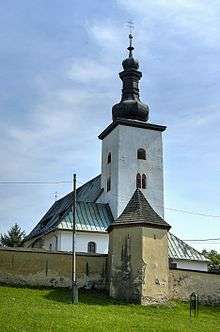
 Catholic St. Bartholomew's Church in Prievidza | ||
|
||
| Country | Slovakia | |
|---|---|---|
| Region | Trenčín | |
| District | Prievidza | |
| Tourism region | Horná Nitra | |
| River | Nitra, Handlovka | |
| Elevation | 280 m (919 ft) | |
| Coordinates | SK 48°46′16″N 18°37′18″E / 48.77111°N 18.62167°ECoordinates: SK 48°46′16″N 18°37′18″E / 48.77111°N 18.62167°E | |
| Area | 43.063 km2 (16.627 sq mi) | |
| Population | 49,387 (2012-01-01) | |
| Density | 1,147/km2 (2,971/sq mi) | |
| First mentioned | 1113 | |
| Mayor | Katarína Macháčková | |
| Timezone | CET (UTC+1) | |
| - summer (DST) | CEST (UTC+2) | |
| Postal code | 971 01 | |
| Area code | +421-46 | |
| Car plate | PD | |
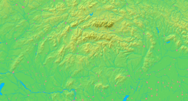  Location in Slovakia | ||
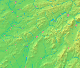  Location in the Trenčín Region | ||
| Wikimedia Commons: Prievidza | ||
| Statistics: MOŠ/MIS | ||
| Website: www.prievidza.sk | ||

Prievidza (![]() pronunciation ; Hungarian: Privigye, German: Priwitz) is a city in the central-western Slovakia. With 49,400 inhabitants it is the second biggest municipality in the Trenčín Region.
pronunciation ; Hungarian: Privigye, German: Priwitz) is a city in the central-western Slovakia. With 49,400 inhabitants it is the second biggest municipality in the Trenčín Region.
Name
The name is probably deduced from a personal name Previd with possessive sufix -ja (Previd's village). An alternative and less probable is a derivation from vid- (Slovak: vidieť - to see, "previdieť" - to see through), thus "the village which can be seen from all directions", "the village in the thin stand".[1]
Features
Prievidza is a centre for many institutions of regional importance - governmental as well as commercial. It is commonly called the "green city". The most prominent sporting clubs include the BC Prievidza (basketball; last champion of Czechoslovakia before separation and later champion of Slovakia); of certain notoriety are also Prievidza Football Club and the ice hockey Club, both of which compete in the appropriate second national leagues.
Prievidza has 6 boroughs: Staré mesto (Old Town in English), Píly, Necpaly, Kopanice, Zápotôčky and Žabník and there are three adjoining villages that are an administrative part of Prievidza: Hradec, Malá Lehôtka and Veľká Lehôtka.
History
The city was first mentioned in 1113 as Preuigan. It was promoted to a royal free town in 1383. Since the 16th century, craftsmanship was developing in Prievidza. From the 16th to the first third of the 17th century, the Thurzó family controlled the town. Ottomans approached Prievidza from the south and burned it in 1599, along with other towns in the upper Nitra river valley. During the Kuruc uprising in 1673, Prievidza was burned down again, with fire burning a part of town's archives. In 1870, it had 2,719 inhabitants. Since the end of the 19th century and the beginning of the 20th century, industry started to grow, as the railways to Prievidza were constructed. During World War II, the city was one of the centres of partisans. On 4 April 1945, Prievidza was captured by troops of the Soviet 40th Army. Since the end of the war, the population has grown enormously from 5,000 inhabitants to around 53,000 inhabitants, as industry grew. Prievidza became the home of many miners and workers that found employment in the coal mines, the power station and the chemical factory in the nearby town of Nováky.
Geography
Prievidza lies at an altitude of 280 metres (919 ft) above sea level and covers an area of 43.06 square kilometres (16.6 sq mi).[2] The city is situated very near the smaller but more famous town of Bojnice, actually sharing the public transport system. The valley of the Nitra River, in which the city lies, is surrounded by mountain ranges on all sides, in the west Strážov Mountains, in the north Malá Fatra, in the east Žiar and in the south Vtáčnik. Prievidza is the eleventh largest city in Slovakia. It is located around 60 kilometres (37 mi) south of Žilina, 69 kilometres (43 mi) km east of the regional capital Trenčín and 158 kilometres (98 mi) km from Bratislava (by road).
Demographics
According to the 2001 census, the town had 53,097 inhabitants. 96.65% of inhabitants were Slovaks, 0.95% Czechs, 0.48% Hungarian and 0.29% Roma and Germans.[2] The religious make-up was 61.91% Roman Catholics, 29.01% people with no religious affiliation and 2.29% Lutherans.[2]
Climate
Prievidza lies in the north temperate zone and has a continental climate with four distinct seasons. It is characterized by a significant variation between hot summers and cold, snowy winters.
| Climate data for Prievidza | |||||||||||||
|---|---|---|---|---|---|---|---|---|---|---|---|---|---|
| Month | Jan | Feb | Mar | Apr | May | Jun | Jul | Aug | Sep | Oct | Nov | Dec | Year |
| Average high °C (°F) | 2 (35) |
5 (41) |
9 (49) |
16 (60) |
22 (71) |
24 (76) |
26 (78) |
26 (80) |
20 (69) |
15 (59) |
8 (47) |
2 (36) |
14.6 (58.4) |
| Average low °C (°F) | −4 (24) |
−4 (25) |
0 (31) |
4 (40) |
9 (48) |
12 (53) |
13 (56) |
13 (56) |
9 (49) |
6 (41) |
2 (35) |
−3 (26) |
4.8 (40.3) |
| Average precipitation cm (inches) | 4.05 (1.59) |
4.28 (1.69) |
3.72 (1.46) |
4.62 (1.82) |
5.50 (2.17) |
8.46 (3.33) |
7.98 (3.14) |
7.63 (3.00) |
6.34 (2.50) |
4.98 (1.96) |
5.02 (1.98) |
3.62 (1.43) |
66.2 (26.07) |
| Source: MSN Weather[3] | |||||||||||||
Partner towns
-
 Ibbenbüren, Germany
 -
 Šumperk, Czech Republic
 -
 Luserna San Giovanni, Italy
 -
 Valjevo, Serbia
 -
 Velenje, Slovenia
 -
 Jastrzębie-Zdrój, Poland
References
- ↑ Martin Štefánik - Ján Lukačka et al. 2010, Lexikón stredovekých miest na Slovensku, Historický ústav SAV, Bratislava, 2010, pp. 354, 360, ISBN 978-80-89396-11-5. http://forumhistoriae.sk/-/lexikon-stredovekych-miest-na-slovensku
- 1 2 3 "Municipal Statistics". Statistical Office of the Slovak republic. Archived from the original on 11 January 2008. Retrieved 2008-01-22.
- ↑ "Monthly Averages for Prievidza, Slovakia". MSN. Retrieved 22 January 2008.
External links
- Official website of Prievidza with information in English
- Official website of Prievidza with information in Slovak
| Wikimedia Commons has media related to Prievidza. |